` `
Arbeiten mit Projektionen
QGIS ermöglicht es, globale und projektbezogene KBS (Koordinatenbezugssysteme) für Layer ohne vordefinierte KBS zu definieren. Es können benutzerdefinierte Koordinatenbezugssysteme erstellt werden und für Raster- und Vektorlayer wird On-The-Fly (OTF) Projektion unterstützt, um Layer gemeinsam und lagegenau darzustellen, auch wenn sie unterschiedliche KBSs besitzen.
Überblick zur Projektionsunterstützung
QGIS unterstützt etwa 2700 bekannte Koordinatenbezugssysteme (KBS). Diese sind in einer SQlite-Datenbank abgelegt, die mit QGIS installiert wird Normalerweise muss diese Datenbank nicht editiert werden, und es kann Probleme verursachen, wenn Sie es dennoch versuchen. Selbst definierte KBS sind in einer Benutzerdatenbank abgelegt. Informationen zum Anlegen einer Benutzerdatenbank finden Sie im Abschnitt Eigenes Koordinatenbezugssystem definieren.
Die Koordinatenbezugssysteme in QGIS basieren auf EPSG Codes der European Petroloium Survey Group und dem Institut Geographic National de France (IGNF) und entsprechen weitestgehend den spatial reference Tabellen der Software GDAL. Die EPSG IDs sind in einer SQlite-Datenbank abgelegt und werden benutzt, um KBS in QGIS zu spezifizieren.
In order to use OTF projection, either your data must contain information about its coordinate reference system or you will need to define a global, layer or project-wide CRS. For PostGIS layers, QGIS uses the spatial reference identifier that was specified when the layer was created. For data supported by OGR, QGIS relies on the presence of a recognized means of specifying the CRS. In the case of shapefiles, this means a file containing the well-known text (WKT) specification of the CRS. This projection file has the same base name as the shapefile and a .prj extension. For example, a shapefile named alaska.shp would have a corresponding projection file named alaska.prj.
Whenever you select a new CRS, the layer units will automatically be
changed in the General tab of the  Project Properties dialog under the Project
(or
  Settings) menu.
Bestimmung einer globalen Projektion
QGIS starts each new project using the global default projection. The global
default CRS is EPSG:4326 - WGS 84 (proj=longlat +ellps=WGS84 +datum=WGS84 +no_defs),
and it comes predefined in QGIS. This default can be changed via the  Select CRS button in the first section, which is used to define the default
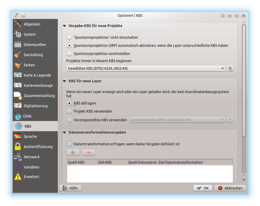
coordinate reference system for new projects, as shown in
figure_projection_options. This choice will be saved for use in subsequent QGIS
sessions.

Menü KBS im QGIS Optionen Dialog
Wenn Sie Layer, die kein KBS besitzen, verwenden, müssen Sie festlegen wie QGIS auf diese Layer reagiert. Dies kann global oder projektbezogen im KBS Menü unter Einstellungen ‣  Optionen erfolgen.
The options shown in figure_projection_options are:
 KBS abfragen
 KBS des Projektes nutzen
 Folgendes KBS benutzen
If you want to define the coordinate reference system for a certain layer without CRS information, you can also do that in the General tab of the raster and vector properties dialog (see General Properties for rasters and General Properties for vectors). If your layer already has a CRS defined, it will be displayed as shown in General tab in vector layers properties dialog.
Tipp
CRS in the Layers Panel
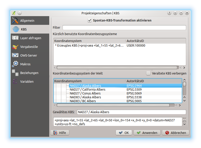
Right-clicking on a layer in the Layers Panel (section Layers Panel) provides two CRS shortcuts. Set layer CRS takes you directly to the Coordinate Reference System Selector dialog (see figure_projection_project). Set project CRS from Layer redefines the project CRS using the layer’s CRS.
Define On The Fly (OTF) CRS Transformation
QGIS supports on the fly CRS transformation for both raster and vector data. However, OTF is not activated by default. When OTF is off, each layer is drawn using the coordinates as read from the data source. When OTF is on, each layer’s coordinates are transformed to the CRS of the project.
There are three ways to enable On The Fly CRS Transformation:
- Select
 Project Properties ‣ CRS from
the Project ( or
  Settings) menu. You
can then activate the
  Enable on the fly CRS
transformation (OTF) checkbox in the
  CRS tab and select
the CRS to use (see Coordinate Reference System Selector)
 - Click on the
 CRS status icon in the lower right-hand
corner of the status bar, leading you to the previous dialog.
 - Turn OTF on by default in the
 CRS tab of the
Settings ‣ Options dialog by selecting
  Enable ‘on the fly’ reprojection by default or
Automatically enable ‘on the fly’ reprojection if layers have
different CRS.
If you have already loaded a layer and you want to enable OTF reprojection, the
best practice is to open the  CRS tab of the Project
Properties dialog, activate the
  Enable ‘on the fly’
CRS transformation checkbox, and select a CRS.
The
  CRS status icon will no longer be greyed out, and all
layers will be OTF projected to the CRS shown next to the icon.

Dialog Projekteigenschaften
Coordinate Reference System Selector
This dialog helps you assign a Coordinate Reference System to a project or a layer, provided a set of projection databases. Items in the dialog are:
- Filter: If you know the EPSG code, the identifier, or the name for a coordinate reference system, you can use the search feature to find it. Enter the EPSG code, the identifier or the name.
- Recently used coordinate reference systems: If you have certain CRSs that you frequently use in your everyday GIS work, these will be displayed in this list. Click on one of these items to select the associated CRS.
- Coordinate reference systems of the world: This is a list of all CRSs supported by QGIS, including Geographic, Projected and Custom coordinate reference systems. To define a CRS, select it from the list by expanding the appropriate node and selecting the CRS. The active CRS is preselected.
- PROJ.4 text: This is the CRS string used by the PROJ.4 projection engine. This text is read-only and provided for informational purposes.
Tipp
Looking for a layer CRS? Use the CRS selector.
Sometimes, you receive a layer and you don’t know its projection. Assuming that you have another layer with a valid crs that should overlaps with it, enable the OTF reprojection and, in the General tab of the Layer properties dialog, use the Coordinate Reference System selector to assign a projection. Your layer position is then moved accordingly. You may have to do some trial and error in order to find the right position, hence its original CRS.
Bemerkung
When operating across layers, for example, computing intersections between two layers, it is important that both layers have the same CRS. To change the projection of an existing layer, it is insufficient to simply change the CRS in that layer’s properties. Instead you must save the layer as a new layer, and choose the desired CRS for the new layer.
Eigenes Koordinatenbezugssystem definieren
Wenn QGIS nicht das Koordinatenbezugssystem das Sie brauchen zur Verfügung stellt können Sie ein Benutzerdefiniertes Koordinatensystem definieren. Um ein KBS zu definieren wählen Sie  Benutzerkoordinatenbezugssystem ... aus dem Menü Einstellungen. Benutzerkoordinatenbezugssysteme werden in Ihrer QGIS Benutzerdatenbank gespeichert. Zusätzlich zu Ihrem Benutzerkoordinatensystem enthält diese Datenbank auch Ihre Räumlichen Lesezeichen und andere Benutzerdaten.

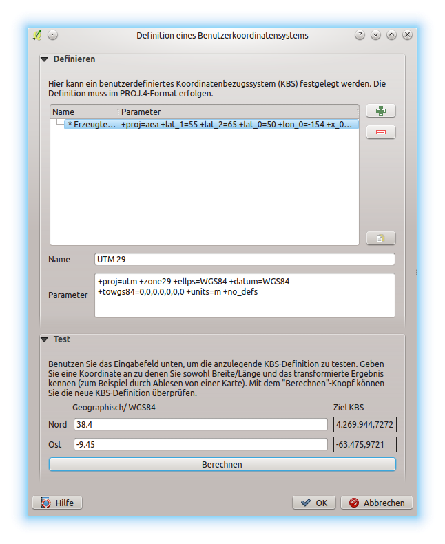
Der Benutzerkoordinatensystem Dialog
Wenn man in QGIS eine eigene Projektion erstellen möchte bedarf es einem grundlegenden Verständnis im Umgang mit der PROJ.4-Bibliothek. Zu Beginn sollten Sie einen Blick in das Benutzerhandbuch von PROJ werfen. “Cartographic Projection Procedures for the UNIX Environment - A User’s Manual” by Gerald I. Evenden, U.S. Geological Survey Open-File Report 90-284, 1990 (zu finden unter ftp://ftp.remotesensing.org/proj/OF90-284.pdf).
Dieses Handbuch beschreibt die Anwendung von proj.4 und die damit verbundenen Kommandozeilenprogramme. Die dort beschriebenen kartographischen Parameter sind identisch mit denen, die in QGIS verwendet werden.
Der Dialog Definition eines Benutzerkoordinatensystems braucht nur zwei Einträge, um eine eigene Projektion zu definieren:
Ein beschreibender Name
Die kartografischen Parameter im PROJ.4-Format
Um ein neues KBS zu erstellen klicken Sie  Neu Knopf und geben Sie einen aussagekräftigen Namen sowie die KBS-Parameter ein.
Denken Sie daran, dass die kartographischen Parameter mit einem +proj=-Block beginnen müssen, um den Beginn eines neuen KBS anzuzeigen.
You can test your CRS parameters to see if they give sane results. To do this, enter known WGS 84 latitude and longitude values in North and East fields, respectively. Click on [Calculate], and compare the results with the known values in your coordinate reference system.
Standard Datumtransformationen
OTF depends on being able to transform data into a ‘default CRS’, and QGIS uses WGS84. For some CRS there are a number of transforms available. QGIS allows you to define the transformation used otherwise QGIS uses a default transformation.
In the CRS tab under Settings ‣  Options you can:
- set QGIS to ask you when it needs define a transformation using
 Ask for datum transformation when no default is defined
 - edit a list of user defaults for transformations.
QGIS asks which transformation to use by opening a dialogue box
displaying PROJ.4 text describing the source and destination
transforms. Further information may be found by hovering over a
transform. User defaults can be saved by selecting
 Remember selection.