Importante
A tradução é um esforço comunitário você pode contribuir. Esta página está atualmente traduzida em 60.47%.
8.2. Lesson: Combining the Analyses
Utilizar los resultados vectorizados del análisis ráster te permitirá seleccionar solo construcciones con terreno adecuado.
El objetivo de esta lección: Utilizar los resultados de terreno vectorizado para seleccionar las parcelas adecuadas.
8.2.1. ★★☆ Try Yourself:
Salve seu mapa atual (:arquivo:`raster_analise.qgs`).
Abra o mapa que você criou durante a análise vetorial anterior (você deveria ter salvo o arquivo como :arquivo:`analises.qgs`).
No painel Camadas, ative estas camadas:
hillshade,solution(orbuildings_over_100)
Além dessas camadas, que já devem estar carregadas no mapa de quando você trabalhou nele antes, adicione também o conjunto de dados :arquivo:`terreno_adequado.shp`.
Se estiver faltando algumas camadas, você deve encontrá-las em :arquivo:`dados_exercício/desenvolvimento_residencial/`
Use the Intersection tool () to create a new vector layer called
new_solution.shpwhich contains only those buildings which intersect thesuitable_terrainlayer.
Ahora deberías tener una capa mostrando ciertas construcciones como tu solución, por ejemplo:
8.2.2. ★★☆ Try Yourself: Inspecting the Results
Look at each of the buildings in your new_solution layer. Compare them
with the suitable_terrain layer by changing the symbology for the
new_solution layer so that it has outlines only. What do you notice
about some of the buildings? Are they all suitable just because they intersect with
the suitable_terrain layer? Why or why not? Which ones would you
deem to be unsuitable?
Responda
You may notice that some of the buildings in your new_solution layer
have been “sliced” by the Intersection tool. This shows that only
part of the building - and therefore only part of the property - lies on
suitable terrain. We can therefore sensibly eliminate those buildings from
our dataset.
8.2.3. ★★☆ Try Yourself: Refining the Analysis
Puedes ver en los resultados que algunas construcciones que estaban incluidas no eran realmente adecuadas, así que ahora podemos refinar el análisis.
We want to ensure that our analysis returns only those buildings which fall
entirely within the suitable_terrain layer. How would you achieve this?
Use one or more Vector Analysis tools and remember that our buildings are all
over 100m squared in size.
Responda
No momento, sua análise deve ser algo assim:
Considere uma área circular, contínua por 100 metros em todas as direções.
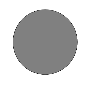
Se for maior que 100 metros de raio, subtrair 100 metros de seu tamanho (de todas as direções) resultará em uma parte dele sendo deixada no meio.
Therefore, you can run an interior buffer of 100 meters on your existing
suitable_terrain vector layer. In the output of the buffer
function, whatever remains of the original layer will represent areas where
there is suitable terrain for 100 meters beyond.
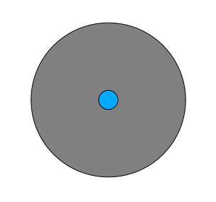
Para demonstrar:
Vá para :seleção de menu:Vetor –> Ferramentas de Geoprocessamento –> Buffer(s) para abrir a caixa de diálogo Buffer(s).
Ajustalo así:
Use the
suitable_terrainlayer with10segments and a buffer distance of-100. (The distance is automatically in meters because your map is using a projected CRS.)Salve a saída em :arquivo:`dados_exercício/desenvolvimento_residencial/` como :arquivo:`adequado_terreno_contínuo100m.shp`.
If necessary, move the new layer above your original
suitable_terrainlayer.Seus resultados ficarão mais ou menos assim:

Agora use a ferramenta Selecionar por localização Ferramenta (: seleção de menu :Vetor –> Ferramentas de pesquisa –> Selecionar por localização).
Configure assim:
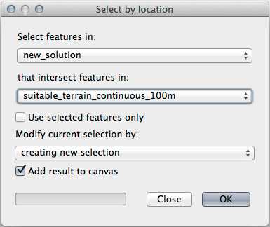
Select features in
new_solutionthat intersect features insuitable_terrain_continuous100m.shp.Este é o resultado:
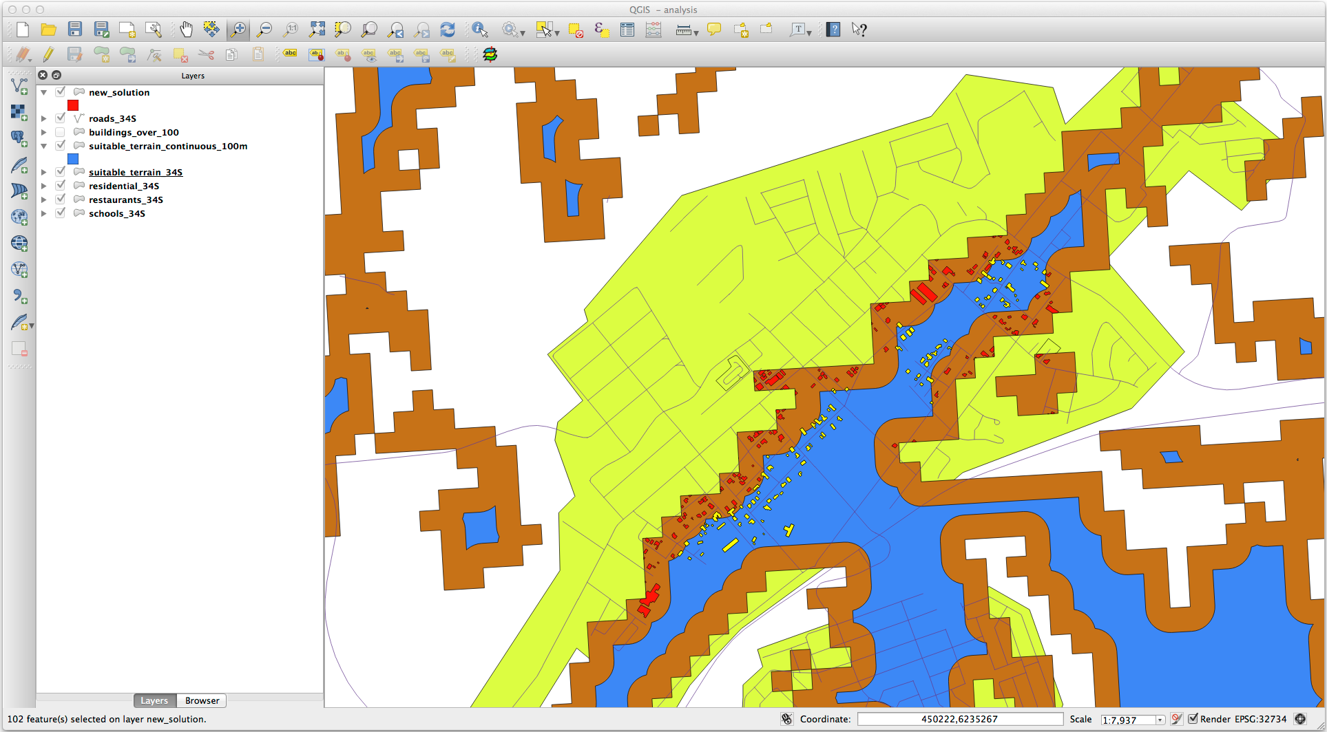
The yellow buildings are selected. Although some of the buildings fall partly outside the new
suitable_terrain_continuous100mlayer, they lie well within the originalsuitable_terrainlayer and therefore meet all of our requirements.Salve a seleção em :arquivo:`exercício_dados/residencial_desenvolvimento/` como :arquivo:`final _resposta.shp`.
8.2.4. In Conclusion
Ahora has respondido a la pregunta original del estudio, y puedes ofrecer una opinión (con razonamientos respaldados en el análisis) para una recomendación respecto a que propiedad desarrollar.
8.2.5. What’s Next?
Lo siguiente será presentar esos resultados como parte de tu segundo ejercicio.