3.2. Web地図サービス (WMS)
The 1.1.1 and 1.3.0 WMS standards implemented in QGIS Server provide a HTTP interface to request map or legend images generated from a QGIS project. A typical WMS request defines the QGIS project to use, the layers to render as well as the image format to generate. Basic support is also available for Styled Layer Descriptor (SLD).
Specifications:
Standard requests provided by QGIS Server:
Request |
説明 |
|---|---|
Returns XML metadata with information about the server |
|
Returns a map |
|
Retrieves data (geometry and values) for a pixel location |
|
Returns legend symbols |
|
Returns XML document with style description in SLD |
|
Returns information about WFS and WCS availability respectively for vector and raster layers |
Vendor requests provided by QGIS Server:
Request |
説明 |
|---|---|
Returns a QGIS layout |
|
Returns specific information about QGIS Server |
|
Returns XML metadata about optional extended capabilities |
3.2.1. GetCapabilities
Standard parameters for the GetCapabilities request according to the OGC WMS 1.1.1 and 1.3.0 specifications:
パラメーター |
必須 |
説明 |
|---|---|---|
はい |
Name of the service (WMS) |
|
はい |
Name of the request (GetCapabilities) |
|
いいえ |
Version of the service |
The GetCapabilities request supports as well the following vendor parameters:
パラメーター |
必須 |
説明 |
|---|---|---|
はい |
QGIS project file |
URL example:
http://localhost/qgis_server?
SERVICE=WMS
&VERSION=1.3.0
&REQUEST=GetCapabilities
3.2.2. GetMap
Standard parameters for the GetMap request according to the OGC WMS 1.1.1 and 1.3.0 specifications:
パラメーター |
必須 |
説明 |
|---|---|---|
はい |
Name of the service (WMS) |
|
はい |
Name of the request (GetMap) |
|
はい |
Version of the service |
|
いいえ |
Layers to display |
|
いいえ |
Layers' style |
|
はい |
座標参照系 |
|
はい |
Map extent |
|
はい |
Width of the image in pixels |
|
はい |
Height of the image in pixels |
|
いいえ |
Image format |
|
いいえ |
透明な背景 |
|
SLD |
いいえ |
URL of an SLD to be used for styling |
SLD_BODY |
いいえ |
In-line SLD (XML) to be used for styling |
In addition to the standard ones, QGIS Server supports redlining, external WMS layers as well as the following extra parameters:
パラメーター |
必須 |
説明 |
|---|---|---|
はい |
QGIS project file |
|
いいえ |
Specify the background color |
|
いいえ |
Specify the output resolution |
|
いいえ |
JPEG compression |
|
いいえ |
Opacity for layer or group |
|
いいえ |
Subset of features |
|
いいえ |
Highlight features |
|
FILE_NAME |
いいえ |
File name of the downloaded file Only for |
いいえ |
Options of the specified file format Only for |
|
いいえ |
Working in tiled mode |
URL example:
http://localhost/qgis_server?
SERVICE=WMS
&VERSION=1.3.0
&REQUEST=GetMap
&MAP=/home/qgis/projects/world.qgs
&LAYERS=mylayer1,mylayer2,mylayer3
&STYLES=style1,default,style3
&OPACITIES=125,200,125
&CRS=EPSG:4326
&WIDTH=400
&HEIGHT=400
&FORMAT=image/png
&TRANSPARENT=TRUE
&DPI=300
&TILED=TRUE
VERSION
This parameter allows to specify the version of the service to use.
Available values for the VERSION parameter are:
1.1.11.3.0
According to the version number, slight differences have to be expected as explained later for the next parameters:
CRS/SRSBBOX
LAYERS
This parameter allows to specify the layers to display on the map. Names have to be separated by a comma.
In addition, QGIS Server introduced some options to select layers by:
the layer id
The project option allowing to select layers by their id is in menu of the dialog. Check the Use layer ids as names checkbox to activate this option.
http://localhost/qgisserver?
SERVICE=WMS
&REQUEST=GetMap
&LAYERS=mylayerid1,mylayerid2
&...
STYLES
This parameter can be used to specify a layer's style for the
rendering step.
Styles have to be separated by a comma. The name of the default style
is default.
SRS / CRS
This parameter allows to indicate the map output Spatial Reference
System in WMS 1.1.1 and has to be formed like EPSG:XXXX.
Note that CRS is also supported if current version is 1.1.1.
For WMS 1.3.0, CRS parameter is preferable but SRS is also
supported.
Note that if both CRS and SRS parameters are indicated in the
request, then it's the current version indicated in VERSION
parameter which is decisive.
In the next case, the SRS parameter is kept whatever the
VERSION parameter because CRS is not indicated:
http://localhost/qgisserver?
SERVICE=WMS
&REQUEST=GetMap
&VERSION=1.3.0
&SRS=EPSG:2854
&...
In the next case, the SRS parameter is kept instead of CRS
because of the VERSION parameter:
http://localhost/qgisserver?
SERVICE=WMS
&REQUEST=GetMap
&VERSION=1.1.1
&CRS=EPSG:4326
&SRS=EPSG:2854
&...
In the next case, the CRS parameter is kept instead of SRS
because of the VERSION parameter:
http://localhost/qgisserver?
SERVICE=WMS
&REQUEST=GetMap
&VERSION=1.3.0
&CRS=EPSG:4326
&SRS=EPSG:2854
&...
BBOX
This parameter allows to specify the map extent with units according to the current CRS. Coordinates have to be separated by a comma.
The BBOX parameter is formed like min_a,min_b,max_a,max_b but a and
b axis definition is different according to the current VERSION
parameter:
in WMS 1.1.1, the axis ordering is always east/north
in WMS 1.3.0, the axis ordering depends on the CRS authority
For example in case of EPSG:4326 and WMS 1.1.1, a is the longitude
(east) and b the latitude (north), leading to a request like:
http://localhost/qgisserver?
SERVICE=WMS
&REQUEST=GetMap
&VERSION=1.1.1
&SRS=epsg:4326
&BBOX=-180,-90,180,90
&...
But in case of WMS 1.3.0, the axis ordering defined in the EPSG database is
north/east so a is the latitude and b the longitude:
http://localhost/qgisserver?
SERVICE=WMS
&REQUEST=GetMap
&VERSION=1.3.0
&CRS=epsg:4326
&BBOX=-90,-180,90,180
&...
WIDTH
This parameter allows to specify the width in pixels of the output image.
HEIGHT
This parameter allows to specify the height in pixels of the output image.
FORMAT
This parameter may be used to specify the format of map image. Available values are:
jpgjpegimage/jpegimage/pngimage/png; mode=1bitimage/png; mode=8bitimage/png; mode=16bitapplication/dxf: only layers that have read access in the WFS service are exported in the DXF formatURL example:
http://localhost/qgisserver?
SERVICE=WMS&VERSION=1.3.0
&REQUEST=GetMap
&FORMAT=application/dxf
&LAYERS=Haltungen,Normschacht,Spezialbauwerke
&CRS=EPSG%3A21781
&BBOX=696136.28844801,245797.12108743,696318.91114315,245939.25832905
&WIDTH=1042
&HEIGHT=811
&FORMAT_OPTIONS=MODE:SYMBOLLAYERSYMBOLOGY;SCALE:250
&FILE_NAME=plan.dxf
TRANSPARENT
This boolean parameter can be used to specify the background transparency. Available values are (not case sensitive):
TRUEFALSE
However, this parameter is ignored if the format of the image indicated with
FORMAT is different from PNG.
BGCOLOR
This parameter allows to indicate a background color for the map image.
However it cannot be combined with TRANSPARENT parameter in case of
PNG images (transparency takes priority). The colour may be literal or
in hexadecimal notation.
URL example with the literal notation:
http://localhost/qgisserver?
SERVICE=WMS
&REQUEST=GetMap
&VERSION=1.3.0
&BGCOLOR=green
&...
URL example with the hexadecimal notation:
http://localhost/qgisserver?
SERVICE=WMS
&REQUEST=GetMap
&VERSION=1.3.0
&BGCOLOR=0x00FF00
&...
DPI
This parameter can be used to specify the requested output resolution.
IMAGE_QUALITY
This parameter is only used for JPEG images. By default, the JPEG
compression is -1.
You can change the default per QGIS project in the
menu of the
dialog.
If you want to override it in a GetMap request you can do it using
the IMAGE_QUALITY parameter.
OPACITIES
Comma separated list of opacity values.
Opacity can be set on layer or group level. Allowed values range from
0 (fully transparent) to 255 (fully opaque).
URL example:
http://localhost/qgisserver?
SERVICE=WMS
&REQUEST=GetMap
&VERSION=1.3.0
&WIDTH=400
&HEIGHT=200
&CRS=EPSG:4326
&LAYERS=countries,places
&BBOX=42,-6,52,15
&OPACITIES=255,0
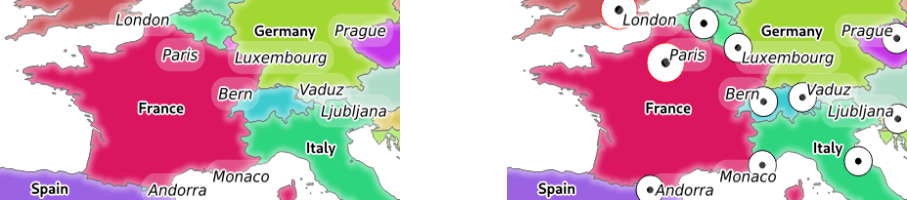
図 3.2 To the left OPACITIES=255,0 and to the right OPACITIES=255,255
FILTER
A subset of layers can be selected with the FILTER parameter.
The syntax is basically the same as for the QGIS subset string.
However, there are some restrictions to avoid SQL injections into
databases via QGIS Server.
If a dangerous string is found in the parameter, QGIS Server will
return the next error:
<ServiceExceptionReport>
  <ServiceException code="Security">The filter string XXXXXXXXX has been rejected because of security reasons.
  Note: Text strings have to be enclosed in single or double quotes. A space between each word / special character is mandatory.
  Allowed Keywords and special characters are IS,NOT,NULL,AND,OR,IN,=,<,=<,>,>=,!=,',',(,),DMETAPHONE,SOUNDEX.
  Not allowed are semicolons in the filter expression.</ServiceException>
</ServiceExceptionReport>
URL example:
http://localhost/qgisserver?
SERVICE=WMS
&REQUEST=GetMap
&VERSION=1.3.0
&WIDTH=400
&HEIGHT=300
&CRS=EPSG:4326
&BBOX=41,-6,52,10
&LAYERS=countries_shapeburst,countries,places
&FILTER=countries_shapeburst,countries:"name" = 'France';places: "name" = 'Paris'
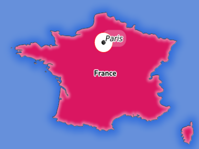
図 3.3 Server response to a GetMap request with FILTER parameter
In this example, the same filter "name" = 'France' is applied to layers
countries and countries_shapeburst, while the filter "name" =
'Paris' is only applied to places.
注釈
It is possible to make attribute searches via GetFeatureInfo and omit the X/Y parameter if a FILTER is there. QGIS Server then returns info about the matching features and generates a combined bounding box in the XML output.
SELECTION
The SELECTION parameter can highlight features from one or more
layers.
Vector features can be selected by passing comma separated lists with
feature ids.
http://localhost/qgisserver?
SERVICE=WMS
&REQUEST=GetMap
&LAYERS=mylayer1,mylayer2
&SELECTION=mylayer1:3,6,9;mylayer2:1,5,6
&...
The following image presents the response from a GetMap request using
the SELECTION option e.g.
http://myserver.com/...&SELECTION=countries:171,65.
As those features id's correspond in the source dataset to France and Romania they're highlighted in yellow.
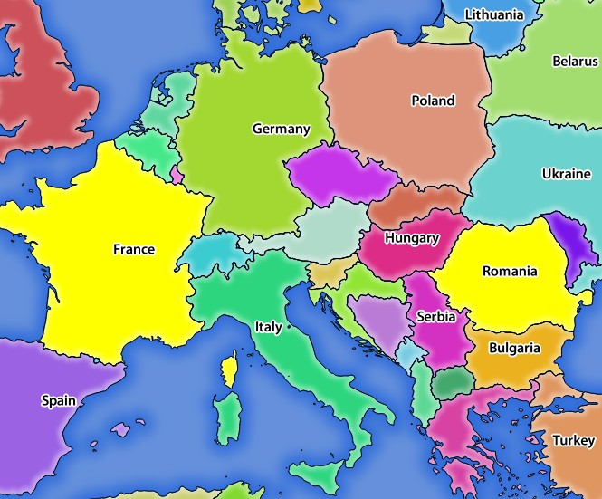
図 3.4 SELECTIONパラメーターを指定したGetMapリクエストに対するサーバーの応答
FORMAT-OPTIONS
This parameter can be used to specify options for the selected format.
Only for FORMAT=application/dxf.
A list of key:value pairs separated by semicolon:
SCALE: to be used for symbology rules, filters and styles (not actual scaling of the data - data remains in the original scale).
MODE: corresponds to the export options offered in the QGIS Desktop DXF export dialog. Possible values are
NOSYMBOLOGY,FEATURESYMBOLOGYandSYMBOLLAYERSYMBOLOGY.LAYERSATTRIBUTES: specify a field that contains values for DXF layer names - if not specified, the original QGIS layer names are used.
USE_TITLE_AS_LAYERNAME: if enabled, the title of the layer will be used as layer name.
CODEC: specify a codec to be used for encoding. Default is
ISO-8859-1check the QGIS desktop DXF export dialog for valid values.NO_MTEXT: Use TEXT instead of MTEXT for labels.
FORCE_2D: Force 2D output. This is required for polyline width.
TILED
For performance reasons, QGIS Server can be used in tiled mode. In this mode, the client requests several small fixed size tiles, and assembles them to form the whole map. Doing this, symbols at or near the boundary between two tiles may appeared cut, because they are only present in one of the tile.
Set the TILED parameter to TRUE to tell QGIS Server to work in
tiled mode, and to apply the Tile buffer configured in the QGIS
project (see Configure your project).
When TILED is TRUE and when a non-zero Tile buffer is
configured in the QGIS project, features outside the tile extent are
drawn to avoid cut symbols at tile boundaries.
TILED defaults to FALSE.
3.2.3. GetFeatureInfo
Standard parameters for the GetFeatureInfo request according to the OGC WMS 1.1.1 and 1.3.0 specifications:
パラメーター |
必須 |
説明 |
|---|---|---|
はい |
Name of the service (WMS) |
|
はい |
Name of the request (GetFeatureInfo) |
|
いいえ |
Version of the service |
|
はい |
Layers to query |
|
はい |
Layers to display (identical to QUERY_LAYERS) |
|
いいえ |
Layers' style |
|
はい |
座標参照系 |
|
いいえ |
Map extent |
|
はい |
Width of the image in pixels |
|
はい |
Height of the image in pixels |
|
いいえ |
透明な背景 |
|
いいえ |
出力形式 |
|
いいえ |
Maximum number of features to return |
|
いいえ |
Pixel column of the point to query |
|
いいえ |
Same as I parameter, but in WMS 1.1.1 |
|
いいえ |
Pixel row of the point to query |
|
いいえ |
Same as J parameter, but in WMS 1.1.1 |
|
WMS_PRECISION |
いいえ |
The precision (number of digits) to be used
when returning geometry (see how to add geometry to feature response).
The default value is |
標準のものに加えて、QGISサーバーでは以下の追加パラメータをサポートしています:
パラメーター |
必須 |
説明 |
|---|---|---|
はい |
QGIS project file |
|
いいえ |
Subset of features |
|
いいえ |
Tolerance in pixels for point layers |
|
いいえ |
ラインレイヤでの許容誤差(ピクセル) |
|
いいえ |
Tolerance in pixels for polygon layers |
|
いいえ |
Geometry filtering |
|
いいえ |
Add map tips to the output |
|
いいえ |
Add geometry to the output |
URL example:
http://localhost/qgisserver?
SERVICE=WMS
&VERSION=1.3.0
&REQUEST=GetMap
&MAP=/home/qgis/projects/world.qgs
&LAYERS=mylayer1,mylayer2,mylayer3
&CRS=EPSG:4326
&WIDTH=400
&HEIGHT=400
&INFO_FORMAT=text/xml
&TRANSPARENT=TRUE
&QUERY_LAYERS=mylayer1
&FEATURE_COUNT=3
&I=250
&J=250
INFO_FORMAT
このパラメータは結果のフォーマットを指定するために使用されます。利用可能な値は以下のとおりです:
text/xmltext/htmltext/plainapplication/vnd.ogc.gmlapplication/json
QUERY_LAYERS
This parameter specifies the layers to display on the map. Names are separated by a comma.
In addition, QGIS Server introduces options to select layers by:
short name
layer id
See the LAYERS parameter defined in
GetMap for more information.
FEATURE_COUNT
このパラメータでは、レイヤごとに返す地物の最大数を指定します。例えば、 QUERY_LAYERS が layer1,layer2 に設定され、 FEATURE_COUNT が 3 に設定されている場合、layer1から最大3つの地物が返されます。同様に、layer2から最大3つの地物が返されます。
By default, only 1 feature per layer is returned.
I
This parameter, defined in WMS 1.3.0, allows you to specify the pixel column of the query point.
X
Same parameter as I, but defined in WMS 1.1.1.
J
This parameter, defined in WMS 1.3.0, allows you to specify the pixel row of the query point.
Y
Same parameter as J, but defined in WMS 1.1.1.
FI_POINT_TOLERANCE
このパラメータではラインレイヤでの許容誤差(ピクセル)を指定します。
FI_LINE_TOLERANCE
This parameter specifies the tolerance in pixels for line layers.
FI_POLYGON_TOLERANCE:
This parameter specifies the tolerance in pixels for polygon layers.
FILTER_GEOM
This parameter specifies a WKT geometry with which features have to intersect.
WITH_MAPTIP
This parameter specifies whether to add map tips to the output.
Available values are (not case sensitive):
TRUEFALSE
WITH_GEOMETRY
This parameter specifies whether to add geometries to the output. To use this feature you must first enable the Add geometry to feature response option in the QGIS project. See Configure your project.
Available values are (not case sensitive):
TRUEFALSE
3.2.4. GetLegendGraphics
Standard parameters for the GetLegendGraphics request according to the OGC WMS 1.1.1 and 1.3.0 specifications:
パラメーター |
必須 |
説明 |
|---|---|---|
はい |
Name of the service (WMS) |
|
はい |
Name of the request (GetLegendGraphics) |
|
いいえ |
Version of the service |
|
はい |
Layers to display |
|
いいえ |
Layers' style |
|
いいえ |
座標参照系 |
|
いいえ |
Map extent |
|
いいえ |
Width of the image in pixels |
|
いいえ |
Height of the image in pixels |
|
いいえ |
Legend format |
|
いいえ |
透明な背景 |
In addition to the standard ones, QGIS Server supports extra parameters to change the size of the legend elements or the font properties for layer titles and item labels:
パラメーター |
必須 |
説明 |
|---|---|---|
はい |
QGIS project file |
|
いいえ |
Map width |
|
いいえ |
Map height |
|
いいえ |
Add feature count of features |
|
いいえ |
Rule symbol to render |
|
いいえ |
Item labels rendering |
|
いいえ |
Space between legend frame and content (mm) |
|
いいえ |
Vertical space between layers (mm) |
|
いいえ |
Vertical space between layer title and items (mm) |
|
いいえ |
Vertical space between symbol and items (mm) |
|
いいえ |
Horizontal space between symbol and label (mm) |
|
いいえ |
Width of the symbol preview (mm) |
|
いいえ |
Height of the symbol preview (mm) |
|
いいえ |
Layer title rendering |
|
いいえ |
Layer font family |
|
いいえ |
Layer title bold rendering |
|
いいえ |
Layer title font size (pt) |
|
いいえ |
Layer title italic rendering |
|
いいえ |
Layer title color |
|
いいえ |
Item font family |
|
いいえ |
Item label bold rendering |
|
いいえ |
Item label font size (pt) |
|
いいえ |
Item label italic rendering |
|
いいえ |
Item label color |
BBOX
This parameter can be used to specify the geographical area for which the
legend should be built (its format is described here) but
cannot be combined with the RULE parameter. The SRS/CRS parameter
becomes mandatory when using the BBOX parameter.
URL example:
http://localhost/qgisserver?
SERVICE=WMS
&REQUEST=GetLegendGraphics
&LAYERS=countries,airports
&BBOX=43.20,-2.93,49.35,8.32
&CRS=EPSG:4326
注釈
When the BBOX parameter is defined, the legend is referred to as a
content based legend.
WIDTH
This parameter is not used by default but becomes mandatory when the RULE
parameter is set. In this case it allows to specify the width in pixels of the
output image.
http://localhost/qgisserver?
SERVICE=WMS
&REQUEST=GetLegendGraphics
&LAYER=testlayer%20%C3%A8%C3%A9
&RULE=rule1
&WIDTH=30
&HEIGHT=30
HEIGHT
This parameter is not used by default but becomes mandatory when the RULE
parameter is set. In this case it allows to specify the height in pixels of the
output image.
http://localhost/qgisserver?
SERVICE=WMS
&REQUEST=GetLegendGraphics
&LAYER=testlayer%20%C3%A8%C3%A9
&RULE=rule1
&WIDTH=30
&HEIGHT=30
FORMAT
This parameter may be used to specify the format of legend image. Available values are:
image/jpegimage/pngapplication/json
For JSON, symbols are encoded with Base64 and most other options related to
layout or fonts are not taken into account because the legend must be built on
the client side. The RULE parameter cannot be combined with this format.
URL example with the corresponding JSON output:
http://localhost/qgisserver?
SERVICE=WMS&
REQUEST=GetLegendGraphics&
LAYERS=airports&
FORMAT=application/json
And the corresponding JSON output:
{
  "nodes":[
    {
      "icon":"<base64 icon>",
      "title":"airports",
      "type":"layer"
    }
  ],
  "title":""
}
SRCWIDTH
This parameter may de defined when the RULE parameter is set. In this case,
the SRCWIDTH value is forwarded to the underlying GetMap request as the
WIDTH parameter while the WIDTH parameter of GetLegendGraphics is
used for the image legend size.
SRCHEIGHT
This parameter may de defined when the RULE parameter is set. In this case,
the SRCHEIGHT value is forwarded to the underlying GetMap request as
the HEIGHT parameter while the HEIGHT parameter of GetLegendGraphics
is used for the image legend size.
SHOWFEATURECOUNT
This parameter can be used to activate feature count in the legend. Available values are (not case sensitive):
TRUEFALSE
For example:
RULE
This parameter is available on layers with Rule-based rendering and
allows to build a legend with only the named rule symbol. It cannot be combined
with BBOX parameter nor the JSON format.
URL example:
http://localhost/qgisserver?
SERVICE=WMS
&REQUEST=GetLegendGraphics
&LAYERS=mylayer,
&RULE=myrulename
RULELABEL
This parameter allows to control the item label rendering. Available values are (not case sensitive):
TRUE: display item labelFALSE: hide item labelAUTO: hide item label for layers with Single symbol rendering
URL example:
http://localhost/qgisserver?
SERVICE=WMS
&REQUEST=GetLegendGraphics
&LAYERS=countries,airports
&BBOX=43.20,-2.93,49.35,8.32
&CRS=EPSG:4326
&TRANSPARENT=TRUE
&RULELABEL=AUTO

図 3.5 Legend rendering without label for single symbol layers
BOXSPACE
This parameter allows to specify the space between legend frame and content in
millimeters. By default, the space value is 2 mm.
URL example:
http://localhost/qgisserver?
SERVICE=WMS
&REQUEST=GetLegendGraphics
&LAYERS=airports
&BBOX=43.20,-2.93,49.35,8.32
&CRS=EPSG:4326
&TRANSPARENT=TRUE
&BOXSPACE=0

図 3.6 To the left BOXSPACE=0 and to the right BOXSPACE=15
LAYERSPACE
This parameter allows to specify the vertical space between layers in
millimeters. By default, the space value is 3 mm.
URL example:
http://localhost/qgisserver?
SERVICE=WMS
&REQUEST=GetLegendGraphics
&LAYERS=airports,places
&BBOX=43.20,-2.93,49.35,8.32
&CRS=EPSG:4326
&TRANSPARENT=TRUE
&LAYERSPACE=0
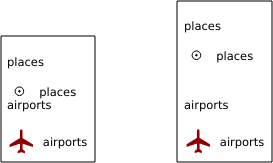
図 3.7 To the left LAYERSPACE=0 and to the right LAYERSPACE=10
LAYERTITLESPACE
This parameter allows to specify the vertical space between layer title and
items following in millimeters. By default the space value is 3 mm.
URL example:
http://localhost/qgisserver?
SERVICE=WMS
&REQUEST=GetLegendGraphics
&LAYERS=airports,places
&BBOX=43.20,-2.93,49.35,8.32
&CRS=EPSG:4326
&TRANSPARENT=TRUE
&LAYERTITLESPACE=0
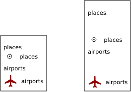
図 3.8 To the left LAYERTITLESPACE=0 and to the right LAYERTITLESPACE=10
SYMBOLSPACE
This parameter allows to specify the vertical space between symbol and item
following in millimeters. By default the space value is 2 mm.
URL example:
http://localhost/qgisserver?
SERVICE=WMS
&REQUEST=GetLegendGraphics
&LAYERS=countries
&BBOX=43.20,-2.93,49.35,8.32
&CRS=EPSG:4326
&TRANSPARENT=TRUE
&SYMBOLSPACE=0
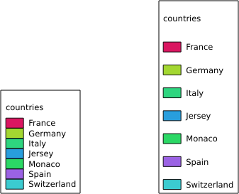
図 3.9 To the left SYMBOLSPACE=0 and to the right SYMBOLSPACE=5
ICONLABELSPACE
This parameter allows to specify the horizontal space between symbol and label
text in millimeters. By default the space value is 2 mm.
URL example:
http://localhost/qgisserver?
SERVICE=WMS
&REQUEST=GetLegendGraphics
&LAYERS=countries,
&BBOX=43.20,-2.93,49.35,8.32
&CRS=EPSG:4326
&TRANSPARENT=TRUE
&ICONLABELSPACE=0
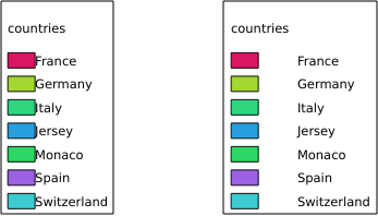
図 3.10 To the left ICONLABELSPACE=0 and to the right ICONLABELSPACE=10
SYMBOLWIDTH
This parameter allows to specify the width of the symbol preview in
millimeters. By default the width value is 7 mm.
URL example:
http://localhost/qgisserver?
SERVICE=WMS
&REQUEST=GetLegendGraphics
&LAYERS=countries,
&BBOX=43.20,-2.93,49.35,8.32
&CRS=EPSG:4326
&TRANSPARENT=TRUE
&SYMBOLWIDTH=2
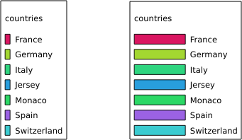
図 3.11 To the left SYMBOLWIDTH=2 and to the right SYMBOLWIDTH=20
SYMBOLHEIGHT
This parameter allows to specify the height of the symbol preview in
millimeters. By default the height value is 4 mm.
URL example:
http://localhost/qgisserver?
SERVICE=WMS
&REQUEST=GetLegendGraphics
&LAYERS=countries,
&BBOX=43.20,-2.93,49.35,8.32
&CRS=EPSG:4326
&TRANSPARENT=TRUE
&SYMBOLHEIGHT=2
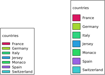
図 3.12 To the left SYMBOLHEIGHT=2 and to the right SYMBOLHEIGHT=6
LAYERTITLE
This parameter specifies whether to render layer title.
Available values are (not case sensitive):
TRUE(default value)FALSE
LAYERFONTFAMILY
This parameter specifies the font family to use for rendering layer title.
http://localhost/qgisserver?
SERVICE=WMS
&REQUEST=GetLegendGraphics
&LAYERS=countries
&LAYERFONTFAMILY=monospace
LAYERFONTBOLD
This parameter specifies whether the layer title is rendered in bold. Available values are (not case sensitive):
TRUEFALSE
URL example:
http://localhost/qgisserver?
SERVICE=WMS
&REQUEST=GetLegendGraphics
&LAYERS=airports,places
&BBOX=43.20,-2.93,49.35,8.32
&CRS=EPSG:4326
&TRANSPARENT=TRUE
&LAYERFONTBOLD=TRUE

図 3.13 Legend with LAYERFONTBOLD=TRUE
LAYERFONTSIZE
This parameter specifies the font size for rendering layer title in point.
URL example:
http://localhost/qgisserver?
SERVICE=WMS
&REQUEST=GetLegendGraphics
&LAYERS=airports,places
&BBOX=43.20,-2.93,49.35,8.32
&CRS=EPSG:4326
&TRANSPARENT=TRUE
&LAYERFONTSIZE=20

図 3.14 Legend with LAYERFONTSIZE=20
LAYERFONTITALIC
This parameter specifies whether the layer title is rendered in italic. Available values are (not case sensitive):
TRUEFALSE
URL example:
http://localhost/qgisserver?
SERVICE=WMS
&REQUEST=GetLegendGraphics
&LAYERS=airports,places
&BBOX=43.20,-2.93,49.35,8.32
&CRS=EPSG:4326
&TRANSPARENT=TRUE
&LAYERFONTITALIC=TRUE

図 3.15 Legend with LAYERFONTITALIC=TRUE
LAYERFONTCOLOR
This parameter specifies the layer title color. The color may be literal
(red, green, ..) or in hexadecimal notation (0xFF0000,
0x00FF00, ...).
URL example:
http://localhost/qgisserver?
SERVICE=WMS
&REQUEST=GetLegendGraphics
&LAYERS=airports,places
&BBOX=43.20,-2.93,49.35,8.32
&CRS=EPSG:4326
&TRANSPARENT=TRUE
&LAYERFONTCOLOR=0x5f9930
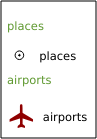
図 3.16 Legend with LAYERFONTCOLOR=0x5f9930
ITEMFONTFAMILY
This parameter specifies the font family to use for rendering item label.
http://localhost/qgisserver?
SERVICE=WMS
&REQUEST=GetLegendGraphics
&LAYERS=countries
&ITEMFONTFAMILY=monospace
ITEMFONTBOLD
This parameter specifies whether the item label is rendered in bold. Available values are (not case sensitive):
TRUEFALSE
URL example:
http://localhost/qgisserver?
SERVICE=WMS
&REQUEST=GetLegendGraphics
&LAYERS=airports,places
&BBOX=43.20,-2.93,49.35,8.32
&CRS=EPSG:4326
&TRANSPARENT=TRUE
&ITEMFONTBOLD=TRUE

図 3.17 Legend with ITEMFONTBOLD=TRUE
ITEMFONTSIZE
This parameter specifies the font size for rendering layer title in point.
URL example:
http://localhost/qgisserver?
SERVICE=WMS
&REQUEST=GetLegendGraphics
&LAYERS=airports,places
&BBOX=43.20,-2.93,49.35,8.32
&CRS=EPSG:4326
&TRANSPARENT=TRUE
&ITEMFONTSIZE=20

図 3.18 Legend with ITEMFONTSIZE=30
ITEMFONTITALIC
This parameter specifies whether the item label is rendered in italic. Available values are (not case sensitive):
TRUEFALSE
URL example:
http://localhost/qgisserver?
SERVICE=WMS
&REQUEST=GetLegendGraphics
&LAYERS=airports,places
&BBOX=43.20,-2.93,49.35,8.32
&CRS=EPSG:4326
&TRANSPARENT=TRUE
&ITEMFONTITALIC=TRUE

図 3.19 Legend with ITEMFONTITALIC=TRUE
ITEMFONTCOLOR
This parameter specifies the item label color. The color may be literal
(red, green, ..) or in hexadecimal notation (0xFF0000,
0x00FF00, ...).
URL example:
http://localhost/qgisserver?
SERVICE=WMS
&REQUEST=GetLegendGraphics
&LAYERS=airports,places
&BBOX=43.20,-2.93,49.35,8.32
&CRS=EPSG:4326
&TRANSPARENT=TRUE
&ITEMFONTCOLOR=0x5f9930
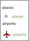
図 3.20 Legend with ITEMFONTCOLOR=0x5f9930
3.2.5. GetStyle(s)
Standard parameters for the GetStyle (or GetStyles) request according to the OGC WMS 1.1.1 specifications:
パラメーター |
必須 |
説明 |
|---|---|---|
はい |
Name of the service (WMS) |
|
はい |
Name of the request (GetStyle or GetStyles) |
|
はい |
Layers to query |
The GetStyle request supports as well the following vendor parameters:
パラメーター |
必須 |
説明 |
|---|---|---|
はい |
QGIS project file |
URL example:
http://localhost/qgisserver?
SERVICE=WMS
&REQUEST=GetStyles
&LAYERS=mylayer1,mylayer2
3.2.6. DescribeLayer
Standard parameters for the DescribeLayer request according to the OGC WMS 1.1.1 and 1.3.0 specifications:
パラメーター |
必須 |
説明 |
|---|---|---|
はい |
Name of the service (WMS) |
|
はい |
Name of the request (DescribeLayer) |
|
はい |
Layers to describe |
|
はい |
SLD version |
The DescribeLayer request supports as well the following vendor parameters:
パラメーター |
必須 |
説明 |
|---|---|---|
はい |
QGIS project file |
URL example:
http://localhost/qgisserver?
SERVICE=WMS
&REQUEST=DescribeLayer
&SLD_VERSION=1.1.0
&LAYERS=mylayer1
The XML document looks like:
<DescribeLayerResponse xmlns="http://www.opengis.net/sld" xmlns:xsi="http://www.w3.org/2001/XMLSchema-instance" xmlns:ows="http://www.opengis.net/ows" xmlns:xlink="http://www.w3.org/1999/xlink" xmlns:se="http://www.opengis.net/se" xsi:schemaLocation="http://www.opengis.net/sld http://schemas.opengis.net/sld/1.1.0/DescribeLayer.xsd">
    <Version>1.1.0</Version>
    <LayerDescription>
        <owsType>wfs</owsType>
        <se:OnlineResource xlink:href="http://localhost/qgis_server" xlink:type="simple"/>
        <TypeName>
            <se:FeatureTypeName>my_vector_layer</se:FeatureTypeName>
        </TypeName>
    </LayerDescription>
    <LayerDescription>
        <owsType>wcs</owsType>
        <se:OnlineResource xlink:href="http://localhost/qgis_server" xlink:type="simple"/>
        <TypeName>
            <se:FeatureTypeName>my_raster_layer</se:FeatureTypeName>
        </TypeName>
    </LayerDescription>
</DescribeLayerResponse>
SLD_VERSION
This parameter allows to specify the version of SLD. Only the value 1.1.0
is available.
3.2.7. GetPrint
QGISサーバには、PDFまたはピクセル形式のプリントレイアウト出力を作成する機能があります。公表されたプロジェクトでのプリントレイアウトがテンプレートとして使用されます。GETPRINT要求では、クライアントは含まれているレイアウト地図とラベルのパラメータを指定する可能性があります。
The GetPrint request supports redlining, external WMS layers as well as the following parameters:
パラメーター |
必須 |
説明 |
|---|---|---|
はい |
QGIS project file |
|
はい |
Name of the service (WMS) |
|
はい |
Name of the request (GetPrint) |
|
いいえ |
Version of the service |
|
いいえ |
Layers to display |
|
はい |
Layout template to use |
|
はい |
座標参照系 |
|
いいえ |
出力形式 |
|
いいえ |
Atlas features |
|
いいえ |
Layers' style |
|
いいえ |
透明な背景 |
|
いいえ |
Opacity for layer or group |
|
いいえ |
Highlight features |
|
いいえ |
Extent of the map 'X' |
|
いいえ |
Layers of the map 'X' |
|
いいえ |
Layers' style of the map 'X' |
|
いいえ |
Layers' scale of the map 'X' |
|
いいえ |
Rotation of the map 'X' |
|
いいえ |
Grid interval on x axis of the map 'X' |
|
いいえ |
Grid interval on y axis of the map 'X' |
URL example:
http://localhost/qgisserver?
SERVICE=WMS
&VERSION=1.3.0
&REQUEST=GetPrint
&MAP=/home/qgis/projects/world.qgs
&CRS=EPSG:4326
&FORMAT=png
&TEMPLATE=Layout%201
&map0:EXTENT=-180,-90,180,90
&map0:LAYERS=mylayer1,mylayer2,mylayer3
&map0:OPACITIES=125,200,125
&map0:ROTATION=45
レイアウトテンプレートには複数のマップが含まれている可能性があることに注意してください。このように、特定のマップを設定したい場合は、 mapX: パラメータを使う必要があります。ここで、 X は GetProjectSettings リクエストのおかげで取得できる正数です。
For example:
<WMS_Capabilities>
...
<ComposerTemplates xsi:type="wms:_ExtendedCapabilities">
<ComposerTemplate width="297" height="210" name="Druckzusammenstellung 1">
<ComposerMap width="171" height="133" name="map0"/>
<ComposerMap width="49" height="46" name="map1"/></ComposerTemplate>
</ComposerTemplates>
...
</WMS_Capabilities>
TEMPLATE
This parameter can be used to specify the name of a layout template to use for printing.
FORMAT
This parameter specifies the format of map image. Available values are:
png(default value)image/pngjpgjpegimage/jpegsvgimage/svgimage/svg+xmlpdfapplication/pdf
If the FORMAT parameter is different from one of these values,
then an exception is returned.
ATLAS_PK
This parameter allows activation of Atlas rendering by indicating
which features we want to print.
In order to retrieve an atlas with all features, the * symbol may
be used (according to the maximum number of features allowed in the
project configuration).
When FORMAT is pdf, a single PDF document combining the feature
pages is returned.
For all other formats, a single page is returned.
mapX:EXTENT
This parameter specifies the extent for a layout map item as xmin,ymin,xmax,ymax.
mapX:ROTATION
This parameter specifies the map rotation in degrees.
mapX:GRID_INTERVAL_X
This parameter specifies the grid line density in the X direction.
mapX:GRID_INTERVAL_Y
This parameter specifies the grid line density in the Y direction.
mapX:SCALE
このパラメータは、レイアウト地図アイテムの地図縮尺を指定します。これは、クライアントとサーバーで縮尺分母を計算するアルゴリズムが異なる場合でもレイヤとラベルの縮尺に基づく可視性を確保するのに役立ちます。
mapX:LAYERS
This parameter specifies the layers for a layout map item. See GetMap Layers for more information on this parameter.
mapX:STYLES
This parameter specifies the layers' styles defined in a specific layout map item. See GetMap Styles for more information on this parameter.
3.2.8. GetProjectSettings
This request type works similar to GetCapabilities, but it is more specific to QGIS Server and allows a client to read additional information which are not available in the GetCapabilities output:
レイヤーの初期可視性
ベクターの属性とその編集タイプに関する情報
レイヤーの順序と描画順序に関する情報
WFSに掲載されたレイヤのリスト
show if a group in the layer tree is mutually exclusive
The GetProjectSettings request supports the following parameters:
パラメーター |
必須 |
説明 |
|---|---|---|
はい |
QGIS project file |
|
はい |
Name of the service (WMS) |
|
はい |
Name of the request (GetProjectSettings) |
3.2.9. GetSchemaExtension
The GetSchemaExtension request allows to retrieve optional extended capabilities and operations of the WMS service such as implemented by QGIS Server.
パラメーター |
必須 |
説明 |
|---|---|---|
はい |
QGIS project file |
|
はい |
Name of the service (WMS) |
|
はい |
Name of the request (GetSchemaExtension) |
URL example:
http://localhost/qgisserver?
SERVICE=WMS
&REQUEST=GetSchemaExtension
The XML document looks like:
<schema xmlns="http://www.w3.org/2001/XMLSchema" xmlns:wms="http://www.opengis.net/wms" xmlns:qgs="http://www.qgis.org/wms" targetNamespace="http://www.qgis.org/wms" elementFormDefault="qualified" version="1.0.0">
    <import namespace="http://www.opengis.net/wms" schemaLocation="http://schemas.opengis.net/wms/1.3.0/capabilities_1_3_0.xsd"/>
    <element name="GetPrint" type="wms:OperationType" substitutionGroup="wms:_ExtendedOperation"/>
    <element name="GetStyles" type="wms:OperationType" substitutionGroup="wms:_ExtendedOperation"/>
</schema>
3.2.10. External WMS layers
QGIS Server allows including layers from external WMS servers in WMS GetMap and WMS GetPrint requests. This is especially useful if a web client uses an external background layer in the web map. For performance reasons, such layers should be directly requested by the web client (not cascaded via QGIS server). For printing however, these layers should be cascaded via QGIS server in order to appear in the printed map.
External layers can be added to the LAYERS parameter as EXTERNAL_WMS:<layername>. The parameters for the external WMS layers (e.g. url, format, dpiMode, crs, layers, styles) can later be given as service parameters <layername>:<parameter>. In a GetMap request, this might look like this:
http://localhost/qgisserver?
SERVICE=WMS
&REQUEST=GetMap
&LAYERS=EXTERNAL_WMS:basemap,layer1,layer2
&OPACITIES=100,200,255
&STYLES=,,
&basemap:url=http://externalserver.com/wms.fcgi
&basemap:format=image/jpeg
&basemap:dpiMode=7
&basemap:crs=EPSG:2056
&basemap:layers=orthofoto
&basemap:styles=default
Similarly, external layers can be used in GetPrint requests:
http://localhost/qgisserver?
SERVICE=WMS
&REQUEST=GetPrint
&TEMPLATE=A4
&map0:layers=EXTERNAL_WMS:basemap,layer1,layer2
&map0:EXTENT=<minx,miny,maxx,maxy>
&OPACITIES=100,200,255
&basemap:url=http://externalserver.com/wms.fcgi
&basemap:format=image/jpeg
&basemap:dpiMode=7
&basemap:crs=EPSG:2056
&basemap:layers=orthofoto
&basemap:styles=default
3.2.11. Redlining
This feature is available and can be used with GetMap and GetPrint requests.
赤線引き地物は、リクエスト中のジオメトリとラベルに渡すのに使用できます、標準返された画像(地図)上でサーバーによって重ねあわされます。これにより、ユーザーは、標準地図にないいくつかの領域、場所などに強調(emphasis)またはコメント(ラベル)を追加することが可能になります。
The GetMap request is in the format:
http://localhost/qgisserver?
SERVICE=WMS
&VERSION=1.3.0
&REQUEST=GetMap
&HIGHLIGHT_GEOM=POLYGON((590000 5647000, 590000 6110620, 2500000 6110620, 2500000 5647000, 590000 5647000))
&HIGHLIGHT_SYMBOL=<StyledLayerDescriptor><UserStyle><Name>Highlight</Name><FeatureTypeStyle><Rule><Name>Symbol</Name><LineSymbolizer><Stroke><SvgParameter name="stroke">%23ea1173</SvgParameter><SvgParameter name="stroke-opacity">1</SvgParameter><SvgParameter name="stroke-width">1.6</SvgParameter></Stroke></LineSymbolizer></Rule></FeatureTypeStyle></UserStyle></StyledLayerDescriptor>
&HIGHLIGHT_LABELSTRING=Write label here
&HIGHLIGHT_LABELSIZE=16
&HIGHLIGHT_LABELCOLOR=%23000000
&HIGHLIGHT_LABELBUFFERCOLOR=%23FFFFFF
&HIGHLIGHT_LABELBUFFERSIZE=1.5
The GetPrint equivalent is in the format (note that
mapX: parameter is added to tell which map has redlining):
http://localhost/qgisserver?
SERVICE=WMS
&VERSION=1.3.0
&REQUEST=GetPrint
&map0:HIGHLIGHT_GEOM=POLYGON((590000 5647000, 590000 6110620, 2500000 6110620, 2500000 5647000, 590000 5647000))
&map0:HIGHLIGHT_SYMBOL=<StyledLayerDescriptor><UserStyle><Name>Highlight</Name><FeatureTypeStyle><Rule><Name>Symbol</Name><LineSymbolizer><Stroke><SvgParameter name="stroke">%23ea1173</SvgParameter><SvgParameter name="stroke-opacity">1</SvgParameter><SvgParameter name="stroke-width">1.6</SvgParameter></Stroke></LineSymbolizer></Rule></FeatureTypeStyle></UserStyle></StyledLayerDescriptor>
&map0:HIGHLIGHT_LABELSTRING=Write label here
&map0:HIGHLIGHT_LABELSIZE=16
&map0:HIGHLIGHT_LABELCOLOR=%23000000
&map0:HIGHLIGHT_LABELBUFFERCOLOR=%23FFFFFF
&map0:HIGHLIGHT_LABELBUFFERSIZE=1.5
ポリゴンとラベルが通常地図の上に描かれている、上記の要求によって出力された画像は次のとおりです:
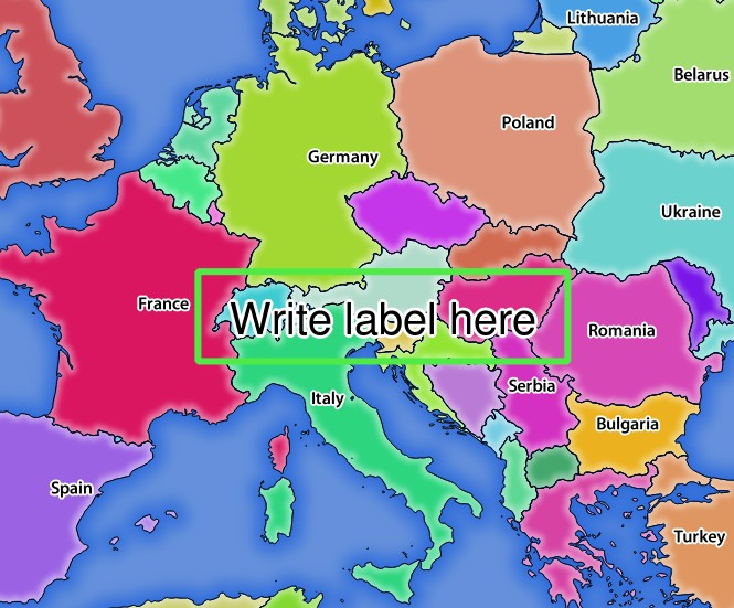
図 3.21 レッドラインパラメーターを持つGetMapリクエストに対するサーバーの応答
このリクエストにはいくつかのパラメーターがあります。
HIGHLIGHT_GEOM: You can add POINT, MULTILINESTRING, POLYGON etc. It supports multipart geometries. Here is an example:
HIGHLIGHT_GEOM=MULTILINESTRING((0 0, 0 1, 1 1)). The coordinates should be in the CRS of the GetMap/GetPrint request.HIGHLIGHT_SYMBOL :ジオメトリの輪郭をどのように表示するかを制御し、ストロークの幅、色、不透明度を変更できます。
HIGHLIGHT_LABELSTRING :ラベルのテキストをこのパラメーターに渡すことができます。
HIGHLIGHT_LABELSIZE: このパラメーターは、ラベルのサイズを制御します。
HIGHLIGHT_LABELFONT: This parameter controls the font of the label (e.g. Arial)
HIGHLIGHT_LABELCOLOR: このパラメーターは、ラベルの色を制御します。
HIGHLIGHT_LABELBUFFERCOLOR: このパラメーターは、ラベルバッファの色を制御します。
HIGHLIGHT_LABELBUFFERSIZE: このパラメーターは、ラベルバッファのサイズを制御します。