` `
메타검색 카탈로그 클라이언트
개요
메타검색(MetaSearch)은 메타데이터 카탈로그 서비스와 상호작용하는 QGIS 플러그인으로, 웹 용 OGC 카탈로그 서비스(CSW) 표준을 지원합니다.
메타검색은 QGIS 내부에서 메타데이터 카탈로그를 검색할 수 있는 쉽고 직관적인 접근법과 사용자 친화적인 인터페이스를 제공하고 있습니다.
Search and results of Services in Metasearch
설치
QGIS 2.0 이상 버전은 메타검색을 기본으로 포함하고 있습니다. 모든 의존성은 메타검색 내부에 포함돼 있습니다.
Install MetaSearch from the QGIS plugin manager, or manually from http://plugins.qgis.org/plugins/MetaSearch.
QGIS에서 메타데이터 카탈로그 작업
CSW (Catalog Service for the Web)
CSW (Catalog Service for the Web) is an OGC (Open Geospatial Consortium) specification, that defines common interfaces to discover, browse and query metadata about data, services, and other potential resources.
구동
To start MetaSearch, click  icon or select Web ‣
MetaSearch ‣ MetaSearch via the QGIS main menu. The MetaSearch dialog will
appear. The main GUI consists of three tabs: Services,
Search and Settings.
icon or select Web ‣
MetaSearch ‣ MetaSearch via the QGIS main menu. The MetaSearch dialog will
appear. The main GUI consists of three tabs: Services,
Search and Settings.
카탈로그 서비스 관리
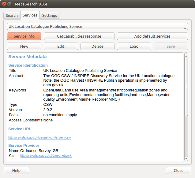
카탈로그 서비스 관리
The Services tab allows the user to manage all available catalog services. MetaSearch provides a default list of Catalog Services, which can be added by pressing [Add default services] button.
목록에 있는 모든 카탈로그 서비스 항목을 보려면, 드롭다운 메뉴를 클릭하십시오.
To add a Catalog Service entry, click the [New] button, and enter a Name for the service, as well as the URL (endpoint). Note that only the base URL is required (not a full GetCapabilities URL). Clicking [OK] will add the service to the list of entries.
To edit an existing Catalog Service entry, select the entry you would like to edit and click the [Edit] button, and modify the Name or URL values, then click [OK].
To delete a Catalog Service entry, select the entry you would like to delete and click the [Delete] button. You will be asked to confirm deleting the entry.
메타검색은 서비스 연결을 XML 파일로 저장하고 불러올 수 있습니다. 서로 다른 응용 프로그램 사이에서 설정을 공유해야 하는 경우 이 기능이 유용합니다. 다음은 이 XML 파일 포맷의 예시입니다.
<?xml version="1.0" encoding="UTF-8"?>
<qgsCSWConnections version="1.0">
    <csw name="Data.gov CSW" url="https://catalog.data.gov/csw-all"/>
    <csw name="Geonorge - National CSW service for Norway" url="http://www.geonorge.no/geonetwork/srv/eng/csw"/>
    <csw name="Geoportale Nazionale - Servizio di ricerca Italiano" url="http://www.pcn.minambiente.it/geoportal/csw"/>
    <csw name="LINZ Data Service" url="http://data.linz.govt.nz/feeds/csw"/>
    <csw name="Nationaal Georegister (Nederland)" url="http://www.nationaalgeoregister.nl/geonetwork/srv/eng/csw"/>
    <csw name="RNDT - Repertorio Nazionale dei Dati Territoriali - Servizio di ricerca" url="http://www.rndt.gov.it/RNDT/CSW"/>
    <csw name="UK Location Catalogue Publishing Service" url="http://csw.data.gov.uk/geonetwork/srv/en/csw"/>
    <csw name="UNEP/GRID-Geneva Metadata Catalog" url="http://metadata.grid.unep.ch:8080/geonetwork/srv/eng/csw"/>
</qgsCSWConnections>
To load a list of entries, click the [Load] button. A new window will appear; click the [Browse] button and navigate to the XML file of entries you wish to load and click [Open]. The list of entries will be displayed. Select the entries you wish to add from the list and click [Load].
Click the [Service info] button to displays information about the selected Catalog Service such as service identification, service provider and contact information. If you would like to view the raw XML response, click the [GetCapabilities response] button. A separate window will open displaying Capabilities XML.
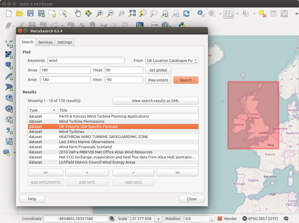
카탈로그 서비스 검색
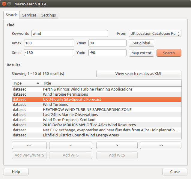
카탈로그 서비스 검색하기
Search 탭에서 데이터 및 서비스에 대해 카탈로그 서비스를 쿼리할 수 있으며, 검색 파라미터 및 검색 결과를 표시하기 위한 다양한 옵션을 설정할 수 있습니다.
다음과 같은 검색 파라미터를 사용할 수 있습니다:
Keywords: 텍스트 검색 키워드를 마음대로 지정할 수 있습니다.
From: 쿼리를 수행할 카탈로그 서비스를 선택합니다.
- Bounding box: the spatial area of interest to filter on defined by Xmax, Xmin, Ymax, and Ymin. Click [Set global] to do a global search, click [Map extent] to do a search on the visible area only or manually enter custom values as desired.
Clicking the [Search] button will search the selected Metadata Catalog. Search results are displayed in a list and are sortable by clicking on the column title. You can navigate through search results with the directional buttons below the search results. Clicking the [View search results as XML] button opens a window with the service response in raw XML format.
Clicking a result will provides the following options:
메타데이터 레코드가 관련 경계 상자를 보유하고 있는 경우, 경계 상자의 범위가 맵 상에 표시될 것입니다.
레코드를 더블클릭하면 관련 접근 링크를 담은 레코드 메타데이터를 표시합니다. 이 링크를 클릭하면 사용자 웹브라우저로 링크를 엽니다.
- if the record is an OGC web service (WMS/WMTS, WFS, WCS), the appropriate [Add to WMS/WMTS|WFS|WCS] buttons will be enabled for the user to add to QGIS. When clicking this button, MetaSearch will verify if this is a valid OWS. The OWS will then be added to the appropriate QGIS connection list, and the appropriate WMS/WMTS|WFS|WCS connection dialog will then appear.
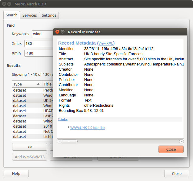
메타데이터 레코드 표시
설정
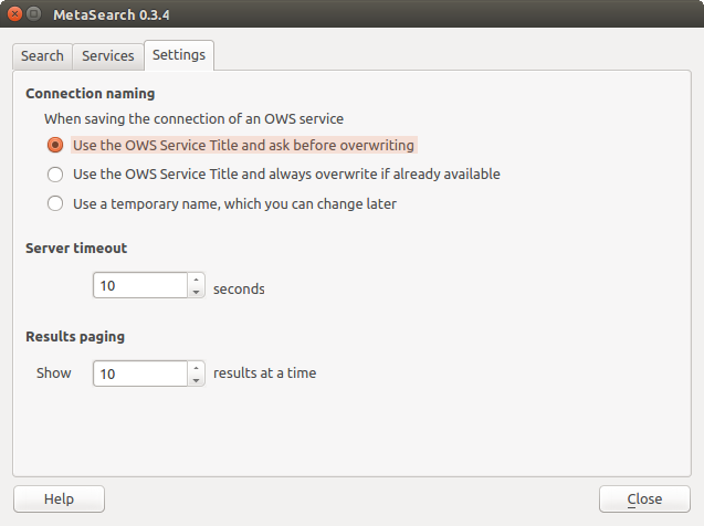
Metasearch setting
Settings 탭에서 메타검색을 다음과 같이 미세 조정할 수 있습니다:
- Connection naming: when adding an OWS connection (WMS/WMTS|WFS|WCS), the connection is stored with the various QGIS layer provider. Use this setting to set whether to use the name provided from MetaSearch, whether to overwrite or to use a temporary name;
Results paging: 메타데이터 카탈로그를 검색할 때, 페이지 당 결과를 몇 개나 표시할지 설정합니다. 기본값은 10입니다.
Timeout: 메타데이터 카탈로그를 검색할 때, 몇 초 후에야 연결 시도 차단으로 판단할지 설정합니다. 기본값은 10입니다.