` `
QGIS 환경 설정
QGIS is highly configurable through the Settings menu. Choose between Options, Project Properties and Customization.
주석
QGIS follows desktop guidelines for the location of options and project properties item. Consequently related to the OS you are using, location of some of items described below could be in the Project or the Settings menu.
옵션
 Options 대화창을 통해 QGIS에 대한 몇몇 기본 옵션을 선택할 수 있습니다. Settings ‣ Options 메뉴 옵션을 선택하십시오. 사용자의 필요에 따라 옵션을 수정할 수 있습니다. 일부 변경 사항은 적용되기 전에 QGIS 재시작이 필요할 수도 있습니다.
사용자 고유 옵션을 사용자 지정할 수 있는 탭들에 대해 다음 항에서 설명하고 있습니다.
일반 설정
응용 프로그램
- Select the Style (QGIS restart required)
 and choose
between ‘Oxygen’, ‘Windows’, ‘Motif’, ‘CDE’, ‘Plastique’ and ‘Cleanlooks’.
and choose
between ‘Oxygen’, ‘Windows’, ‘Motif’, ‘CDE’, ‘Plastique’ and ‘Cleanlooks’. - Define the Icon theme . It can be ‘default’ or ‘Night Mapping’.
- Define the Icon size .
- Define the Font and its Size. The font can be
 Qt default or a user-defined one.
 - Change the Timeout for timed messages or dialogs .
 Hide splash screen at startup
- Show tips at startup
- Check QGIS version at startup to keep you informed
if a newer version is released
- QGIS-styled group boxes
- Use native color chooser dialogs (see 색상 선택기)
- Use live-updating color chooser dialogs (see 색상 선택기)
- Canvas rotation support (restart required)
프로젝트 파일
- Open project on launch (choose between ‘New’,
‘Most recent’, ‘Welcome Page’, and ‘Specific’). When choosing ‘Specific’ use
the
 to define the project to use by default. The ‘Welcome Page’
displays a list of recent projects with screenshot.
to define the project to use by default. The ‘Welcome Page’
displays a list of recent projects with screenshot. - Create new project from default project 를 선택하면 Set current project as default 또는 Reset default 가운데 하나를 클릭할 수 있습니다. 사용자 파일을 탐색하고 사용자가 직접 정의한 프로젝트 템플릿이 있는 디렉터리를 정의할 수 있습니다. 해당 템플릿은 Project ‣ New From Template 메뉴에 추가됩니다. 먼저 Create new project from default project 를 활성화한 경우, 프로젝트 템플릿 폴더에 프로젝트를 저장하십시오.
- Prompt to save project and data source changes when
required
- Prompt for confirmation when a layer is to be removed
- Warn when opening a project file saved with an older
version of QGIS
Enable macros
옵션은 프로젝트 이벤트에 대한 액션을 수행하기 위해 작성된 매크로를 처리하기 위해 만들어졌습니다. ‘Never’, ‘Ask’, ‘For this session only’ 그리고 ‘Always (not recommended)’ 가운데 선택할 수 있습니다.
시스템 설정
SVG 경로
Path(s) to search for Scalable Vector Graphic (SVG) symbols 를 추가하거나 삭제합니다. 피처 심볼 또는 사용자 맵 조판 장식에 이 SVG 파일을 쓸 수 있습니다.
플러그인 경로
Add or Remove Path(s) to search for additional C++ plugin libraries
QSettings
사용자가 어떤 사용자 지정 사항이라도 만들었을 경우 Reset user interface to default settings (restart required) 옵션을 통해 초기화할 수 있습니다.
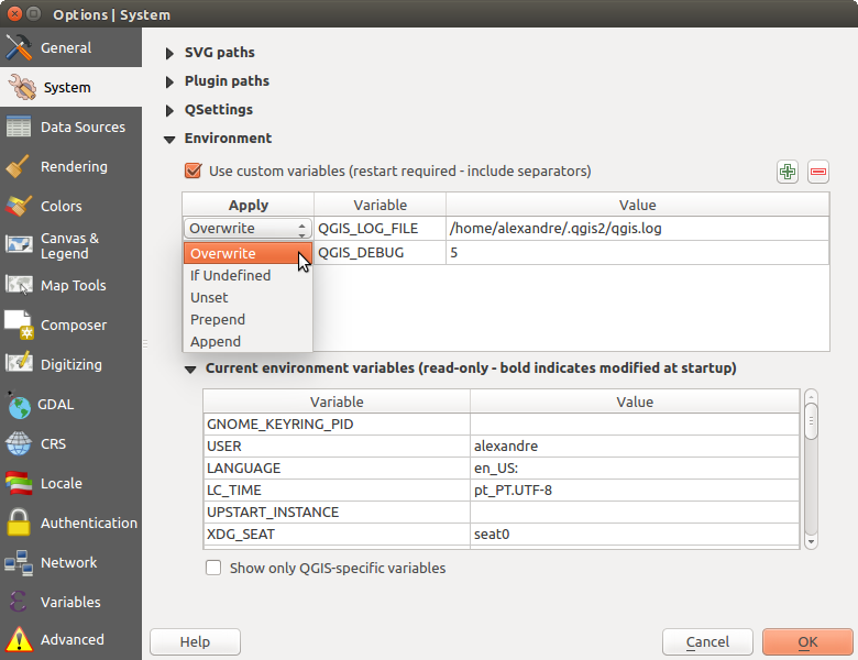
환경
이제 Environment 그룹에서 (QGIS의 시스템 환경 변수 그림 참조) 시스템 환경 변수를 살펴볼 수 있고, 많은 변수를 설정할 수 있습니다. 이 옵션은 맥OS처럼 GUI 응용 프로그램이 사용자의 셸 환경을 반드시 상속하지는 않는 플랫폼에서 유용합니다. SAGA, GRASS 같은 공간 처리 툴박스가 제어하는 외부 도구 모음을 위한 환경 변수들을 설정하고 살펴보는 데에도, 그리고 소스 코드의 특정 부분에 대해 산출물을 디버그하는 작업을 활성화시키는 데에도 유용합니다.
- Use custom variables (restart required - include separators).
You can [Add] and [Remove] variables. Already-defined environment
variables are displayed in Current environment variables, and it’s
possible to filter them by activating
Show only QGIS-specific variables.
QGIS의 시스템 환경 변수
데이터소스 설정
피처 속성 및 테이블
- Open attribute table in a dock window
다른 응용 프로그램의 피처를 붙여넣을 경우 Copy features as 옵션으로 ‘Plain text, no geometry’, ‘Plain text, WKT geometry’, 또는 ‘GeoJSON’ 가운데 하나를 선택합니다.
Attribute table behavior
: 속성 테이블을 열 때의 필터를 설정합니다. ‘Show all features’, ‘Show selected features’ 그리고 ‘Show features visible on map’ 가운데 하나를 선택할 수 있습니다.Default view: 속성 테이블을 열 때의 뷰 모드를 정의합니다. ‘Remember last view’, ‘Table view’ 또는 ‘Form view’ 가운데 하나를 선택할 수 있습니다.
Attribute table row cache
 에서 속성 테이블 관련 작업을 빠르게 처리할 수 있도록 최근 속성 행을 몇 개나 행 캐시에 저장할지 설정할 수 있습니다. 속성 테이블을 닫으면 캐시를 삭제합니다.
Representation for NULL values 을 통해 NULL 값을 포함하는 데이터 항목을 위한 값을 정의할 수 있습니다.
참고
대용량 속성 테이블 열기를 향상시키기
대용량 레코드를 보유한 레이어를 작업하는 경우, 대화창이 레이어에 있는 모든 행을 요구하기 때문에 속성 테이블을 여는 데 시간이 많이 걸릴 수도 있습니다. Attribute table behavior 를 Show Features Visible On Map 으로 설정하면, QGIS가 테이블을 열 때 현재 맵 캔버스에 있는 피처만 요구하므로 데이터를 빨리 불러올 수 있습니다.
이 속성 테이블 인스턴스에 있는 데이터가 언제나 테이블을 열 당시의 캔버스 범위에 구속된다는 사실을 기억하십시오. 즉 해당 테이블에서 Show All Features 를 선택해도 새 피처들을 표시하지 않을 것이라는 뜻입니다. 하지만 속성 테이블에서 Show Features Visible On Map 옵션을 선택하고 캔버스 범위를 변경하면 화면에 표시된 피처 집합을 업데이트할 수 있습니다.
데이터소스 처리
Scan for valid items in the browser dock
을 통해 ‘Check extension’ 과 ‘Check file contents’ 가운데 하나를 선택할 수 있습니다.- Scan for contents of compressed files (.zip) in browser dock
. ‘No’, ‘Basic scan’ and ‘Full scan’ are possible.
Prompt for raster sublayers when opening: 일부 래스터는 GDAL에서 하위 데이터셋이라고 부르는 하위 레이어를 지원합니다. netCDF 파일이 한 예입니다. netCDF 변수가 여러 개 있을 경우, GDAL은 모든 변수를 하위 데이터셋으로 간주합니다. 이 옵션은 하위 레이어를 보유한 파일을 열었을 때 하위 레이어를 어떻게 처리할지를 제어할 수 있게 해줍니다. 다음 가운데 하나를 선택할 수 있습니다:
‘Always’: (하위 레이어가 존재할 경우) 항상 물어봅니다.
‘If needed’: 레이어에 밴드는 없지만 하위 레이어는 있을 경우 물어봅니다.
‘Never’: 물어보지 않고, 아무것도 불러오지 않습니다.
‘Load all’: 물어보지 않지만, 모든 하위 레이어를 불러옵니다.
- Ignore shapefile encoding declaration 을 체크하면 shapefile에 인코딩 정보가 있더라도 QGIS가 무시할 것입니다.
- Add PostGIS layers with double click and select in
extended mode
- Add Oracle layers with double click and select in
extended mode
- Execute expressions on server-side if possible
숨겨진 탐색기 경로
This widget lists all the folder you chose to hide from the Browser panel. Removing a folder from the list will make it available in the Browser panel.
렌더링 설정

프로젝트 속성 대화창의 렌더링 탭
렌더링 습성
- By default new layers added to the map should be displayed
- Use render caching where possible to speed up redraws
- Render layers in parallel using many CPU cores
- Max cores to use
- Map update interval (default to 250 ms)
- Enable feature simplification by default for newly added layers
- Simplification threshold
Simplification algorithm: 이 옵션은 로컬에서 피처를 “실시간(on-the-fly)” 단순화시켜 도형 렌더링 속도를 향상시킵니다. 데이터 제공자에서 불러온 도형을 변경하지는 않습니다. 사용자가 피처 도형을 사용하는 표현식을 사용할 경우 (예를 들어 면적을 계산할 경우) 이 옵션은 중요합니다. 단순화된 도형이 아니라 원본 도형에 대해 계산이 이루어진다는 것을 보장하기 때문입니다. 이를 위해 QGIS는 ‘Distance’(기본값), ‘SnapToGrid’ 그리고 ‘Visvalingam’ 세 가지 알고리즘을 제공합니다.
- Simplify on provider side if possible: PostGIS, Oracle 등의 제공자가 도형을 단순화하며, 로컬 단순화와는 달리 도형 기반 계산에 영향을 줄 수도 있습니다.
- Maximum scale at which the layer should be simplified
 Magnification level (see the magnifier)
주석
일반 수준 설정 이외에도, 특정 레이어의 Layer properties ‣ Rendering 메뉴를 통해서도 피처 단순화를 설정할 수 있습니다.
렌더링 품질
- Make lines appear less jagged at the expense of some
drawing performance
곡선 선분
Segmentation tolerance: 이 설정은 원호(circular arc)를 렌더링하는 방식을 제어합니다. (연속된 꼭짓점 2개와 곡선 중점 사이의, 도 단위의) 최대 각도 또는 (두 꼭짓점의 선분과 곡선 사이의, 맵 단위의) 최대 거리 가운데 더 작은 쪽, 그리고 더 직선에 가까운 선분을 이용해서 렌더링할 것입니다.
Tolerance type: it can be ‘Maximum angle’ or ‘Maximum distance’
래스터
RGB band selection 을 이용해서 적색, 녹색, 청색 밴드의 번호를 정의할 수 있습니다.
Contrast enhancement
- Single band gray . A single band gray can have
‘No stretch’, ‘Stretch to MinMax’, ‘Stretch and Clip to MinMax’ and also
‘Clip to MinMax’.
- Multi band color (byte/band) . Options are ‘No stretch’,
‘Stretch to MinMax’, ‘Stretch and Clip to MinMax’ and ‘Clip to MinMax’.
- Multi band color (>byte/band) . Options are ‘No stretch’,
‘Stretch to MinMax’, ‘Stretch and Clip to MinMax’ and ‘Clip to MinMax’.
- Limits (minimum/maximum) . Options are
‘Cumulative pixel count cut’, ‘Minimum/Maximum’, ‘Mean +/- standard deviation’.
- Cumulative pixel count cut limits
- Standard deviation multiplier
디버그
- Map canvas refresh
색상 설정
This menu allows you to add some custom color that you can find in each color dialog window of the renderers. You will see a set of predefined colors in the tab: you can delete or edit all of them. Moreover you can add the color you want and perform some copy and paste operations. Finally you can export the color set as a gpl file or import them.
캔버스 및 범례 설정
Default map appearance (overridden by project properties)
- Define a Selection color and a Background color.
Layer legend
Double click action in legend
: 더블 클릭을 하면 ‘Open layer properties’를 할지 ‘Open attribute table’을 할지 또는’Open layer styling dock’을 할지 선택할 수 있습니다.- The following Legend item styles are possible:
- Capitalise layer names
- Bold layer names
- Bold group names
- Display classification attribute names
- Create raster icons (may be slow)
- you can also set the WMS getLegendGraphic Resolution
맵 도구 설정
이 탭은 식별 도구 의 습성과 관련된 여러 옵션을 제공합니다.
- Search radius for identifying and displaying map tips is a tolerance distance within which the identify tool will depict results as long as you click within this tolerance.
Highlight color 에서 식별된 피처를 어떤 색상으로 강조할지 선택할 수 있습니다.
Buffer 에서 식별 강조 윤곽선을 어느 정도의 버퍼 거리로 렌더링할지 설정합니다.
Minimum width 에서 강조된 객체의 윤곽선을 얼마나 굵게 할지 설정합니다.
측정 도구
측정 도구 용 Rubberband color 를 정의합니다.
Decimal places 를 정의합니다.
- Keep base unit 을 체크하면 자동적으로 큰 숫자로 (예를 들어 미터를 킬로미터로) 변환하는 걸 막아줍니다.
Preferred distance units
에서 ‘미터’, ‘킬로미터’, ‘피트’, ‘야드’, ‘마일’, ‘해리(Nautical Miles)’, ‘도(Degrees)’ 또는 ‘맵 단위’ 가운데 하나를 선택합니다.- Preferred area units (‘Square meters’, ‘Square
kilometers’, ‘Square feet’, ‘Square yards’, ‘Square miles’, ‘Hectares’,
‘Acres’, ‘Square nautical miles’, ‘Square degrees” or ‘Map Units’)
Preferred angle units
에서 ‘도’, ‘라디안’, 그레이드(Gon/gradians)‘, ‘Minutes of arc‘, ‘Seconds of arc‘ 또는 ‘Turns/revolutions‘ 가운데 하나를 선택합니다.
이동 및 확대/축소
확대/축소 도구 또는 마우스 휠 용 Zoom factor 를 정의합니다.
사전 정의 축척
여기에서 사전 정의된 축척 목록을 볼 수 있습니다.  및
및  버튼으로 사용자 지정 축척을 추가하거나 제거할 수 있습니다. 또 축척을 .XML 파일 포맷으로 내보내거나 불러올 수 있습니다. 사용자 변경 사항을 제거하고 사전 정의 목록으로 초기화할 수 있다는 사실을 기억하십시오.
Composer Settings
조판 기본값
You can define the Default font used within the print composer.
그리드 모양
Grid style
에서 ‘Solid’, ‘Dots’, ‘Crosses’ 가운데 하나를 선택합니다.Grid color 를 정의합니다.
그리드 및 가이드 기본값
Grid spacing
을 정의합니다.- Define the Grid offset for x and y
Snap tolerance
를 정의합니다.
Composer Paths
- Define Path(s) to search for extra print templates: a list of folders with custom composer templates to use while creating new one.
디지타이즈 작업 설정
이 탭에서 벡터 레이어 편집 시 (속성 및 도형) 이용할 수 있는 일반 설정의 환경을 설정할 수 있습니다.
피처 생성
- Suppress attribute form pop-up after feature creation
- Reuse last entered attribute values
Validate geometries. 많은 노드를 보유한 복잡한 라인 및 폴리곤을 편집하는 작업 시 렌더링이 아주 느려질 수 있습니다. QGIS의 기본 유효성 확인 과정에 시간이 오래 걸릴 수 있기 때문입니다. GEOS 도형 유효성 확인을 (GEOS 3.3 버전부터 사용 가능) 활성화하거나, 도형 유효성 확인 과정을 비활성화해서 렌더링 속도를 높일 수 있습니다. GEOS 도형 유효성 확인은 훨씬 빠르지만, 첫 도형 문제점만 표시한다는 단점이 있습니다.
고무줄
- Define Rubberband Line width, Line color and Fill color
- Don’t update rubberband during node editing
스냅
- Open snapping options in a dock window (QGIS restart required)
- Define Default snap mode (‘To vertex’, ‘To segment’,
‘To vertex and segment’, ‘Off’)
Default snapping tolerance 를 정의합니다. 맵 단위 또는 픽셀 개수로 설정할 수 있습니다.
Search radius for vertex edits 을 정의합니다. 맵 단위 또는 픽셀 개수로 설정할 수 있습니다.
꼭짓점 마커
- Show markers only for selected features
꼭짓점 Marker style
을 정의합니다. ‘Cross’ (default), ‘Semi transparent circle’ 또는 ‘None’ 가운데 하나를 선택할 수 있습니다.꼭짓점 Marker size 를 정의합니다.
곡선 오프셋 도구
다음 세 가지 옵션은 고급 디지타이즈 작업 의  Offset Curve 에서 쓰입니다. 다양한 설정을 통해, 라인 오프셋의 형태를 변경할 수 있습니다. GEOS 3.3 버전부터 이 옵션들을 사용할 수 있습니다.
Join style 로 ‘Round’, ‘Mitre’ 또는 ‘Bevel’ 가운데 하나를 선택할 수 있습니다.
- Quadrant segments
- Miter limit
GDAL 설정
GDAL은 래스터 파일 용 데이터 교환 라이브러리입니다. 이 탭에서 래스터 유형의 Edit create options 과 Edit Pyramids Options 을 정의할 수 있습니다. 몇몇 경우 GDAL 드라이버를 하나 이상 사용할 수 있기 때문에, 사용자가 래스터 유형에 대해 어떤 GDAL 드라이버를 사용할지 정의할 수 있습니다.
좌표계 설정
Default CRS for new projects
 Don’t enable ‘on the fly’ reprojection
- Automatically enable ‘on the fly’ reprojection if
layers have different CRS
- Enable ‘on the fly’ reprojection by default
- Select a CRS and Always start new projects with this CRS
새 레이어를 위한 좌표계
여기에서 새 레이어를 생성하거나 좌표계가 정의되지 않은 레이어를 불러올 때 수행할 액션을 정의할 수 있습니다.
- Prompt for CRS
- Use project CRS
- Use default CRS
기본 데이터 변환
- Ask for datum transformation when no default is defined
With the ‘on-the-fly’ CRS transformation enabled and the above option checked, adding layers of different CRS opens the Select datum transformations dialog. This offers you to select the most appropriate transformation settings. Validating this dialog with the ‘Remember selection’ option checked populates the table under CRS ‣ Default datum transformations with information about ‘Source CRS’ and ‘Destination CRS’ as well as ‘Source datum transform’ and ‘Destination datum transform’. From now, QGIS automatically uses the selected datum transformation for further transformation between these two CRSs until you
remove it from the list.You can use the
button to add a datum transformation if you know
its parameters (source and destination ellipsoids and the numbers from the
transformation table). You then need to manually enter each setting.
주석
For more information on how QGIS handles layers projection, please read the dedicated section at 투영 작업.
Locale Settings
- Override system locale and Locale to use instead
- Information about active system locale
Network Tab
일반
WMS search address 를 정의합니다. 기본값은 http://geopole.org/wms/search?search=\%1\&type=rss 입니다.
Timeout for network requests (ms) 를 정의합니다. 기본값은 60,000입니다.
Default expiration period for WMS Capabilities (hours) 를 정의합니다. 기본값은 24입니다.
Default expiration period for WMSC/WMTS tiles (hours) 를 정의합니다. 기본값은 24입니다.
Max retry in case of tile or feature request errors 를 정의합니다.
User-Agent 를 정의합니다.
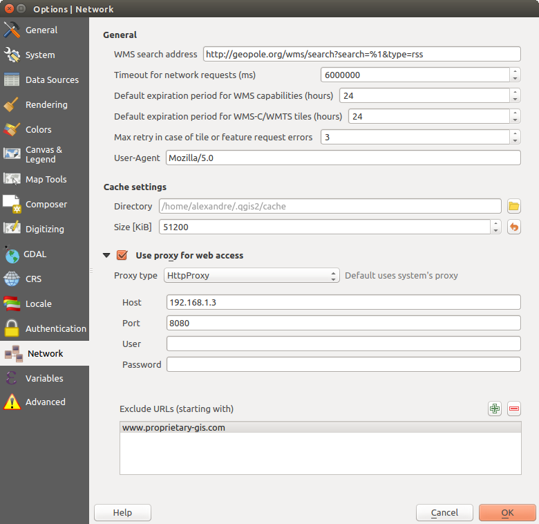
QGIS의 프록시 설정
캐시 설정
Define the Directory and a Size for the cache.
- Use proxy for web access and define ‘Host’, ‘Port’, ‘User’,
and ‘Password’.
- Set the Proxy type according to your needs.
- Default Proxy: Proxy is determined based on the application proxy set using
Socks5Proxy: 모든 종류의 연결에 쓸 수 있는 일반 프록시입니다. TCP, UDP, 지정 포트(들어오는 연결) 그리고 인증을 지원합니다.
HttpProxy: “CONNECT” 명령어로 시행되며, 나가는 TCP 연결만 지원하고, 인증을 지원합니다.
HttpCachingProxy: 통상적인 HTTP 명령어로 시행되며, HTTP 요청이라는 맥락 안에서만 유용합니다.
FtpCachingProxy: FTP 프록시를 이용해서 시행되며, FTP 요청이라는 맥락 안에서만 유용합니다.
프록시 설정 아래에 있는 텍스트 상자에 제외시킬 URL을 추가할 수 있습니다. (QGIS의 프록시 설정 그림 참조)
If you need more detailed information about the different proxy settings, please refer to the manual of the underlying QT library documentation at http://doc.qt.io/qt-4.8/qnetworkproxy.html#ProxyType-enum
참고
프록시 사용
프록시 사용은 때로 까다로울 수 있습니다. 앞에서 설명한 프록시 유형들을 ‘시행착오’를 거쳐 가며 사용자의 환경에서 어떤 유형이 작동하는지 확인하는 편이 좋습니다.
변수 설정
Variables 탭은 전체 수준에서 쓸 수 있는 모든 변수들의 목록을 표시합니다.
또한 사용자가 전체 수준 변수를 관리할 수도 있습니다. 버튼을 클릭해서 새 사용자 지정 전체 수준 변수를 추가합니다. 마찬가지로, 목록에서 사용자 지정 전체 수준 변수를 선택한 다음 버튼을 클릭해서 제거합니다.
Variables 에서 변수에 대한 더 자세한 정보를 살펴볼 수 있습니다.
고급 설정
사용자 OS 별로, QGIS 관련 모든 설정(UI, 도구, 데이터 제공자, 기본값, 플러그인 옵션 등등)을 다음 위치에 저장합니다:
 $HOME/.config/QGIS/QGIS2.conf 텍스트 파일에 설정을 저장합니다.
 $HOME/Library/Preferences/org.qgis.qgis.plist 속성 목록 파일에 설정을 저장합니다.
 HKEY\CURRENT_USER\Software\QGIS\qgis 레지스트리에 설정을 저장합니다.
OS에 상관없이, Advanced 탭의 Advanced Settings Editor 한 곳에서 이 설정들을 관리할 수 있습니다. 사용자 주의 사항을 확인하면 위젯에 모든 QGIS 설정들의 트리가 표시되는데, 사용자가 직접 편집할 수 있습니다.
경고
고급 탭 설정을 무턱대고 이용하지 말 것
이 대화창에서 항목을 수정할 때 조심해야 합니다. 변경 사항이 자동적으로 적용되기 때문입니다. 자세한 내용을 모른 채 설정을 수정하면 사용자의 QGIS 설치본이 여러 방식으로 고장날 수 있습니다.
프로젝트 속성
In the properties window for the project under Project ‣
Project Properties (or  Settings ‣ Project Properties),
you can set project-specific options.
Settings ‣ Project Properties),
you can set project-specific options.
The project-specific options overwrite their equivalent in the options described above.
In the General tab, the general settings let you:
프로젝트 파일 경로 옆에 프로젝트 제목을 부여할 수 있고
피처 선택 시 피처에 적용할 색상을 선택할 수 있고
맵 캔버스에 적용할 배경색을 선택할 수 있으며
프로젝트 내부의 레이어를 가리키는 경로를 절대 경로(전체 경로)로 저장할지 프로젝트 파일 위치에 상대적인 상대 경로로 저장할지 설정할 수 있습니다. 레이어 및 프로젝트 파일이 이동 또는 공유될 가능성이 있거나, 다른 플랫폼을 이용하는 컴퓨터에서 프로젝트에 접근하는 경우, 상대 경로가 더 적합할 수도 있습니다.
프로젝트를 맵 타일로 렌더링할 때 오류(artifact)를 회피하도록 선택할 수 있습니다. 이 옵션을 체크하면 성능이 저하될 수도 있다는 점을 주의하십시오.
Calculating areas and distances is a common need in GIS. However, these values are really tied to the underlying projection settings. The Measurements frame lets you control these parameters. You can indeed choose:
- the ellipsoid to use: it can be an existing one, a custom one (you’ll need to set values of the semi-major and semi-minor axis) or None/Planimetric.
길이 및 둘레에 대한 units for distance measurements 및 면적에 대한 units for area measurements 를 설정하면 현재 프로젝트에서 QGIS 옵션에 설정된 기본 단위를 무시하게 만들며, 다음에 쓰입니다:
속성 테이블 필드 업데이트 바
필드 계산기 계산
식별 도구에서 파생되는 길이, 둘레 및 면적 값
측정 대화창에 표시되는 기본 단위
The Coordinate display allows you to choose and customize the format of units to use to display the mouse coordinate in the status bar and the derived coordinates shown via the identify tool.
Finally, you can define a project scale list, which overrides the global predefined scales.
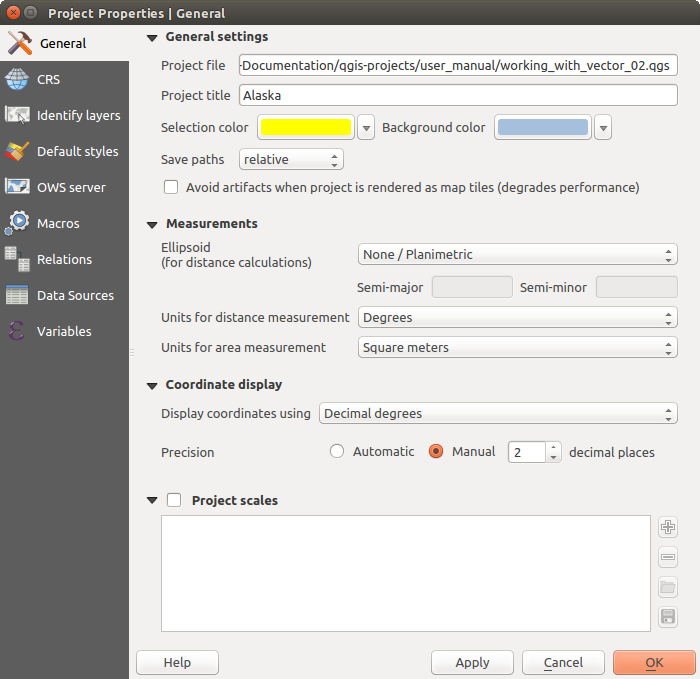
프로젝트 속성 대화창의 일반 탭
The CRS tab enables you to choose the Coordinate Reference System for this project, and to enable on-the-fly re-projection of raster and vector layers when displaying layers from a different CRS. For more information on projection’s handling in QGIS, please read 투영 작업 section.
With the Identify layers tab, you set (or disable) which layers will respond to the identify tool. By default, layers are set queryable.
You can also set whether a layer should appear as read-only, meaning that it can not be edited by the user, regardless of the data provider’s capabilities. Although this is a weak protection, it remains a quick and handy configuration to avoid end-users modifying data when working with file-based layers.
The Default Styles tab lets you control how new layers will be drawn when they do not have an existing .qml style defined. You can also set the default transparency level for new layers and whether symbols should have random colors assigned to them. There is also an additional section where you can define specific colors for the running project. You can find the added colors in the drop down menu of the color dialog window present in each renderer.
The tab OWS Server allows you to configure your project in order to publish it online. Here you can define information about the QGIS Server WMS and WFS capabilities, extent and CRS restrictions. More information available in section Prepare a project to serve and subsequent.
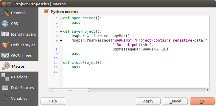
Macros 탭은 프로젝트를 위한 파이썬 매크로를 편집하는 데 쓰입니다. 현재, openProject(), saveProject() 그리고 closeProject() 세 가지 매크로만 사용할 수 있습니다.
QGIS의 매크로 설정
Relations 탭은 일대다(1:n) 관계를 정의하는 데 쓰입니다. 프로젝트 속성 대화창에서 이 관계를 정의합니다. 어떤 레이어에 관계가 존재하는 경우, 양식 뷰에 있는 새 사용자 인터페이스 요소가 (예를 들어 피처를 식별하고 그 양식을 열 때) 관련 요소들의 목록을 표시할 것입니다. 이렇게 되면, 예를 들어 어떤 파이프라인 또는 도로 구간의 점검 이력을 보여줄 수 있는 강력한 방법이 생기는 겁니다. 일대다 또는 다대다 관계 생성 에서 일대다 관계에 대한 더 자세한 내용을 찾아볼 수 있습니다.
Data Sources 탭에서 다음 설정을 할 수 있습니다:
- Evaluate default values on provider side: When adding
new features in a PostGreSQL table, fields with default value constraint are
evaluated and populated at the form opening, and not at the commit moment.
This means that instead of an expression like nextval('serial'), the field
in the Add Feature form will display expected value (e.g., 25).
- Automatically create transaction groups where possible:
When this mode is turned on, all
(postgres) layers from the same database are synchronised in their edit state,
i.e. when one layer is put into edit state, all are, when one layer is committed
or one layer is rolled back, so are the others. Also, instead of buffering edit
changes locally, they are directly sent to a transaction in the database which
gets committed when the user clicks save layer.
Note that you can (de)activate this option only if no layer is being edited
in the project.
Variables 탭은 (모든 전체 수준 변수를 포함하는) 프로젝트 수준에서 사용할 수 있는 모든 변수 목록을 표시합니다. 게다가, 사용자가 프로젝트 수준 변수를 관리할 수도 있습니다.
버튼을 클릭해서 새 사용자 지정 프로젝트 수준 변수를 추가합니다. 마찬가지로, 목록에서 사용자 지정 프로젝트 수준 변수를 선택한 다음 버튼을 클릭해서 제거합니다. 일반 도구 장의 ref:general_tools_variables 절에서 변수 사용법에 대한 자세한 정보를 살펴볼 수 있습니다.
사용자 지정
사용자 지정 작업 대화창을 통해 QGIS 사용자 인터페이스의 거의 모든 요소를 (비)활성화할 수 있습니다. 최종 사용자가 필요로 하는 아이콘, 메뉴 또는 패널만 있는 ‘가벼운’ QGIS 버전을 제공하고자 할 때 매우 유용합니다.
주석
사용자 변경 사항을 적용하려면 QGIS를 재시작해야 합니다.
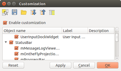
사용자 지정 작업 대화창
Enable customization 체크박스를 체크하는 일이 QGIS 사용자 지정 작업의 첫 번째 단계입니다. 툴바 및 위젯 패널을 활성화하는데, 이 패널에서 몇몇 GUI 항목을 체크 해제해서 쓸 수 없게 만들 수 있습니다.
환경을 설정할 수 있는 항목은 다음과 같습니다:
메뉴 또는 메뉴 바 에 있는 몇몇 하위 메뉴
패널 전체 (패널 및 툴바 참조)
상태 바 에서 설명한 상태 바 또는 상태 바의 몇몇 항목들
툴바 전체 또는 툴바의 일부 아이콘들
라벨, 버튼, 콤보박스 등 QGIS의 모든 대화창의 모든 위젯
 Switch to catching widgets in main application 을 통해, QGIS 인터페이스에서 사용자가 숨기고 싶은 항목을 클릭할 수 있습니다. 그러면 QGIS가 사용자 지정 작업 대화창에서 대응 항목을 자동적으로 체크 해제할 것입니다.
Once you setup your configuration, click [Apply] or [Ok] to validate your changes. This configuration becomes the one used by default by QGIS at the next startup.
 Save To File 버튼을 클릭하면 변경 사항들을 .ini 파일로도 저장할 수 있습니다. 사용자 여러 명이 QGIS 인터페이스를 공유할 수 있는 간편한 방법입니다. 다른 컴퓨터에서 이 .ini 파일을 불러오려면
  Load from File 만 클릭하면 됩니다. 또 명령어 도구 를 실행해서 서로 다른 사용 목적을 위한 다양한 설정을 저장할 수도 있습니다.
참고
사전 정의된 QGIS를 손쉽게 복구
다음 방법들 가운데 하나를 통해 초기 QGIS GUI 환경 설정을 복구할 수 있습니다:
사용자 지정 작업 대화창에서
Enable customization 을 체크 해제하거나  Check All 버튼을 클릭합니다.
- pressing the [Reset] button in the QSettings frame under Settings ‣ Options menu, System tab
명령 프롬프트에서 QGIS를 다음 명령어 qgis --nocustomization 로 실행합니다.
Settings ‣ Options 메뉴의 Advanced 탭에 있는 UI ‣ Customization ‣ Enabled 변수의 값을 false 로 설정합니다. (경고 참조)
대부분의 경우, 이 변경 사항을 적용하려면 QGIS를 재시작해야 합니다.
키보드 단축키
QGIS provides default keyboard shortcuts for many features. You can find them in section 메뉴 바. Additionally, the menu option Settings ‣ Configure Shortcuts... allows you to change the default keyboard shortcuts and add new keyboard shortcuts to QGIS features.
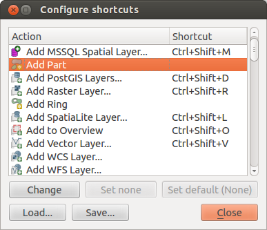
단축키 옵션 정의
Configuration is very simple. Just select a feature from the list and click on :
- [Change] and press the new combination you want to assign as new shortcut
- [Set none] to clear any assigned shortcut
- or [Set default] to backup the shortcut to its original and default value.
Proceed as above for any other tools you wish to customize. Once you have finished your configuration, simply [Close] the dialog to have your changes applied. You can also [Save] the changes as an .XML file and [Load] them into another QGIS installation.