Svarbu
Vertimas yra bendruomenės pastangos, prie kurių jūs galite prisijungti. Šis puslapis šiuo metu išverstas 79.52%.
24.1.29. Vektorinė lentelė
24.1.29.1. Pridėti automatiškai didinamą lauką
Prideda į vektorinį sluoksnį naują sveiko skaičiaus lauką, kuriame kiekvienam geoobjektui reikšmė imama iš sekos.
Šį lauką galima naudoti kaip sluoksnio geoobjektų unikalų ID. Naujas atributas nepridedamas į įvesties sluoksnį, o vietoje to kuriamas naujas sluoksnis.
Galima nurodyti pradinę reikšmę, nuo kurios prasideda seka. Pasirinktinai, didėjanti seka gali remtis laukų grupavimu, taipogi galima nurodyti geoobjektų rikiavimo tvarką.
Parametrai
Užrašas |
Pavadinimas |
Tipas |
Aprašymas |
|---|---|---|---|
Įvesties sluoksnis |
|
[vektorius: bet koks] |
Įvesties vektorinis sluoksnis. |
Lauko pavadinimas |
|
[tekstas] Numatytas: „AUTO“ |
Lauko su automatiškai didinama reikšme pavadinimas |
Reikšmes pradėti nuo Pasirinktinis |
|
[skaičius: sveikas skaičius] Numatytas: 0 |
Parinkite pradinį didėjančios sekos skaičių |
Modulio reikšmė Pasirinktinis |
|
[skaičius: sveikas skaičius] Numatytas: 0 |
Nurodžius neprivalomą modulį, reikšmės bus pradedamos iš naujo nuo START reikšmės, kai lauko reikšmė pasieks modulio reikšmę. |
Grupuoti reikšmes pagal Pasirinktinis |
|
[lentelės laukas: bet koks] [sąrašas] |
Parinkite grupuojamą lauką(us): vietoje vieno skaičiavimo visam sluoksniui, atskiras skaitliukas apdorojamas kiekvienai reikšmei, kurią grąžina šių laukų kombinacija. |
Rikiavimo išraiška Pasirinktinis |
|
[išraiška] |
Naudoti išraišką geoobjektų rikiavimui sluoksnyje globaliai arba, jei nurodyta, pagal grupavimo laukus. |
Rikiuoti didėjančiai |
|
[boolean] Numatytas: Taip |
Nurodžius |
Null reikšmės rikiuotės pradžioje |
|
[boolean] Numatytas: ne |
Nurodžius |
Padidintos |
|
[toks pat, kaip įvestis] Numatytas: |
Nurodykite išvesties vektorinį sluoksnį su automatiškai didinamos reikšmės lauku. Vienas iš:
Čia taipogi galima pakeisti failo koduotę. |
Išvestys
Užrašas |
Pavadinimas |
Tipas |
Aprašymas |
|---|---|---|---|
Padidintos |
|
[toks pat, kaip įvestis] |
Vektorinis sluoksnis su automatiškai didėjančiu lauku |
Pythono kodas
Algoritmo ID: native:addautoincrementalfield
import processing
processing.run("algorithm_id", {parameter_dictionary})
algoritmo id rodomas, kai užvedate pelę virš algoritmo apdorojimo įrankinėje. parametrų žodynas teikia parametrų pavadinimus ir reikšmes. Daugiau informacijos apie tai, kaip vykdyti apdorojimo algoritmus Pythono konsolėje rasite skyriuje Using processing algorithms from the console.
24.1.29.2. Pridėti lauką į atributų lentelę
Prideda į vektorinį sluoksnį naują lauką.
Atributo pavadinimas ir charakteristikos nurodomos kaip parametrai.
Naujas atributas nėra pridedamas į įvesties sluoksnį, vietoje to kuriamas naujas sluoksnis.
Parametrai
Užrašas |
Pavadinimas |
Tipas |
Aprašymas |
|---|---|---|---|
Įvesties sluoksnis |
|
[vektorius: bet koks] |
Įvesties sluoksnis |
Lauko pavadinimas |
|
[tekstas] |
Naujo lauko pavadinimas |
Lauko tipas |
|
[sąrašas] Numatytas: 0 |
Naujo lauko tipas. Galite pasirinkti vieną iš:
|
Lauko ilgis |
|
[skaičius: sveikas skaičius] Numatytas: 10 |
Lauko ilgis |
Lauko tikslumas |
|
[skaičius: sveikas skaičius] Numatytas: 0 |
Lauko tikslumas. Naudojama slankaus kablelio lauko tipui. |
Lauko pseudonimas Pasirinktinis
|
|
[tekstas] |
Nurodykite pavadinimą, kuris turėtų būti naudojamas kaip lauko pseudonimas. Palaikoma ne visiems formatams. |
Lauko komentaras Pasirinktinis
|
|
[tekstas] |
Įrašyti šį lauką aprašantį komentarą. Palaikoma ne visiems formatams. |
Papildytas |
|
[toks pat, kaip įvestis] Numatytas: |
Nurodykite išvesties vektorinį sluoksnį Vienas iš:
Čia taipogi galima pakeisti failo koduotę. |
Išvestys
Užrašas |
Pavadinimas |
Tipas |
Aprašymas |
|---|---|---|---|
Papildytas |
|
[toks pat, kaip įvestis] |
Vektorinis sluoksnis su pridėti nauju lauku |
Pythono kodas
Algoritmo ID: native:addfieldtoattributestable
import processing
processing.run("algorithm_id", {parameter_dictionary})
algoritmo id rodomas, kai užvedate pelę virš algoritmo apdorojimo įrankinėje. parametrų žodynas teikia parametrų pavadinimus ir reikšmes. Daugiau informacijos apie tai, kaip vykdyti apdorojimo algoritmus Pythono konsolėje rasite skyriuje Using processing algorithms from the console.
24.1.29.3. Pridėti unikalios reikšmės indekso lauką
Nurodytam vektoriniam sluoksniui ir atributui prideda naują skaičiaus lauką.
Šio lauko reikšmės atitinka nurodyto atributo reikšmes, taigi geoobjektai su tokia pačia atributo reikšme turės tą pačią reikšmę naujame skaičiaus lauke.
Tai sukuria skaitmeninį nurodyto atributo ekvivalentą, kuris apibrėžia tas pačias klases.
Naujas atributas nėra pridedamas į įvesties sluoksnį, vietoje to kuriamas naujas sluoksnis.
Parametrai
Užrašas |
Pavadinimas |
Tipas |
Aprašymas |
|---|---|---|---|
Įvesties sluoksnis |
|
[vektorius: bet koks] |
Įvesties sluoksnis. |
Klasės laukas |
|
[tablefield: any] |
Geoobjektasi, kurie turi tą pačią šio lauko reikšmę turės tą patį indeksą. |
Išvesties lauko pavadinimas |
|
[tekstas] Numatytas: ‚NUM_FIELD‘ |
Naujo lauko su indeksu pavadinimas. |
Sluoksnis su indekso lauku |
|
[toks pat, kaip įvestis] Numatytas: |
Vektorinis sluoksnis su skaitmeniniu lauku turinčiu indeksus. Vienas iš:
Čia taipogi galima pakeisti failo koduotę. |
Klasės suvestinė |
|
[vektorius: lentelė] Numatytas: |
Nurodykite lentelę, kuri turės klasės lauko suvestinę susietą su atitinkama unikalia reikšme. Vienas iš:
Čia taipogi galima pakeisti failo koduotę. |
Išvestys
Užrašas |
Pavadinimas |
Tipas |
Aprašymas |
|---|---|---|---|
Sluoksnis su indekso lauku |
|
[toks pat, kaip įvestis] |
Vektorinis sluoksnis su skaitiniu lauku turinčiu indeksus. |
Klasės suvestinė |
|
[vektorius: lentelė] |
Lentelė su klasės lauko suvestine susieta su atitinkama unikalia reikšme. |
Pythono kodas
Algoritmo ID: native:adduniquevalueindexfield
import processing
processing.run("algorithm_id", {parameter_dictionary})
algoritmo id rodomas, kai užvedate pelę virš algoritmo apdorojimo įrankinėje. parametrų žodynas teikia parametrų pavadinimus ir reikšmes. Daugiau informacijos apie tai, kaip vykdyti apdorojimo algoritmus Pythono konsolėje rasite skyriuje Using processing algorithms from the console.
24.1.29.4. Add X/Y fields to layer
Adds X and Y (or latitude/longitude) fields to a point layer. The X/Y fields can be calculated in a different CRS to the layer (e.g. creating latitude/longitude fields for a layer in a projected CRS).
 Leidžia taškų geoobjektus keisti vietoje
Parametrai
Užrašas |
Pavadinimas |
Tipas |
Aprašymas |
|---|---|---|---|
Įvesties sluoksnis |
|
[vector: point] |
Įvesties sluoksnis. |
Coordinate system |
|
[crs] Default: „EPSG:4326“ |
Coordinate reference system to use for the generated x and y fields. |
Field prefix Pasirinktinis |
|
[tekstas] |
Prefix to add to the new field names to avoid name collisions with fields in the input layer. |
Added fields |
|
[vector: point] Numatytas: |
Nurodykite išvesties sluoksnį. Vienas iš:
Čia taipogi galima pakeisti failo koduotę. |
Išvestys
Užrašas |
Pavadinimas |
Tipas |
Aprašymas |
|---|---|---|---|
Added fields |
|
[vector: point] |
The output layer - identical to the input layer but with two
new double fields, |
Pythono kodas
Algorithm ID: native:addxyfields
import processing
processing.run("algorithm_id", {parameter_dictionary})
algoritmo id rodomas, kai užvedate pelę virš algoritmo apdorojimo įrankinėje. parametrų žodynas teikia parametrų pavadinimus ir reikšmes. Daugiau informacijos apie tai, kaip vykdyti apdorojimo algoritmus Pythono konsolėje rasite skyriuje Using processing algorithms from the console.
24.1.29.5. Advanced Python field calculator
Adds a new attribute to a vector layer, with values resulting from applying an expression to each feature.
The expression is defined as a Python function.
Įspėjimas
This algorithm is a potential security risk if executed with unchecked inputs, and may result in system damage or data leaks.
Parametrai
Užrašas |
Pavadinimas |
Tipas |
Aprašymas |
|---|---|---|---|
Įvesties sluoksnis |
|
[vektorius: bet koks] |
Įvesties vektorinis sluoksnis |
Result field name |
|
[tekstas] Default: ‚NewField‘ |
Naujo lauko pavadinimas |
Lauko tipas |
|
[sąrašas] Numatytas: 0 |
Type of the new field. One of:
|
Lauko ilgis |
|
[skaičius: sveikas skaičius] Numatytas: 10 |
Lauko ilgis |
Lauko tikslumas |
|
[skaičius: sveikas skaičius] Numatytas: 3 |
Lauko tikslumas. Naudojama slankaus kablelio lauko tipui. |
Global expression Pasirinktinis |
|
[tekstas] |
The code in the global expression section will be executed only once before the calculator starts iterating through all the features of the input layer. Therefore, this is the correct place to import necessary modules or to calculate variables that will be used in subsequent calculations. |
Formula |
|
[tekstas] |
The Python formula to evaluate. Example: To calculate the area of an input polygon layer you can add: value = $geom.area()
To access an existing field use its name enclosed in the angle brackets. For example, to uppercase values of the „address“ field: value = <address>.upper()
|
Calculated |
|
[toks pat, kaip įvestis] Numatytas: |
Specify the vector layer with the new calculated field. One of:
Čia taipogi galima pakeisti failo koduotę. |
Išvestys
Užrašas |
Pavadinimas |
Tipas |
Aprašymas |
|---|---|---|---|
Calculated |
|
[toks pat, kaip įvestis] |
Vector layer with the new calculated field |
Pythono kodas
Algorithm ID: qgis:advancedpythonfieldcalculator
import processing
processing.run("algorithm_id", {parameter_dictionary})
algoritmo id rodomas, kai užvedate pelę virš algoritmo apdorojimo įrankinėje. parametrų žodynas teikia parametrų pavadinimus ir reikšmes. Daugiau informacijos apie tai, kaip vykdyti apdorojimo algoritmus Pythono konsolėje rasite skyriuje Using processing algorithms from the console.
24.1.29.6. Drop field(s)
Takes a vector layer and generates a new one that has the same features but without the selected columns.
Taip pat žiūrėkite
Parametrai
Užrašas |
Pavadinimas |
Tipas |
Aprašymas |
|---|---|---|---|
Įvesties sluoksnis |
|
[vektorius: bet koks] |
Input vector layer to drop field(s) from |
Fields to drop |
|
[lentelės laukas: bet koks] [sąrašas] |
The field(s) to drop |
Remaining fields |
|
[toks pat, kaip įvestis] Numatytas: |
Specify the output vector layer with the remaining fields. One of:
Čia taipogi galima pakeisti failo koduotę. |
Išvestys
Užrašas |
Pavadinimas |
Tipas |
Aprašymas |
|---|---|---|---|
Remaining fields |
|
[toks pat, kaip įvestis] |
Vector layer with the remaining fields |
Pythono kodas
Algorithm ID: native:deletecolumn
import processing
processing.run("algorithm_id", {parameter_dictionary})
algoritmo id rodomas, kai užvedate pelę virš algoritmo apdorojimo įrankinėje. parametrų žodynas teikia parametrų pavadinimus ir reikšmes. Daugiau informacijos apie tai, kaip vykdyti apdorojimo algoritmus Pythono konsolėje rasite skyriuje Using processing algorithms from the console.
24.1.29.7. Explode HStore Field
Creates a copy of the input layer and adds a new field for every unique key in the HStore field.
The expected field list is an optional comma separated list. If this list is specified, only these fields are added and the HStore field is updated. By default, all unique keys are added.
The PostgreSQL HStore
is a simple key-value store used in PostgreSQL and GDAL (when reading
an OSM file
with the other_tags field.
Parametrai
Užrašas |
Pavadinimas |
Tipas |
Aprašymas |
|---|---|---|---|
Įvesties sluoksnis |
|
[vektorius: geometrija] |
Įvesties vektorinis sluoksnis |
HStore field |
|
[tablefield: any] |
The field(s) to drop |
Expected list of fields separated by a comma Pasirinktinis |
|
[tekstas] Numatytas: ‚‘ |
Comma-separated list of fields to extract. The HStore field will be updated by removing these keys. |
Exploded |
|
[toks pat, kaip įvestis] Numatytas: |
Nurodykite išvesties vektorinį sluoksnį. Vienas iš:
Čia taipogi galima pakeisti failo koduotę. |
Išvestys
Užrašas |
Pavadinimas |
Tipas |
Aprašymas |
|---|---|---|---|
Exploded |
|
[toks pat, kaip įvestis] |
Output vector layer |
Pythono kodas
Algorithm ID: native:explodehstorefield
import processing
processing.run("algorithm_id", {parameter_dictionary})
algoritmo id rodomas, kai užvedate pelę virš algoritmo apdorojimo įrankinėje. parametrų žodynas teikia parametrų pavadinimus ir reikšmes. Daugiau informacijos apie tai, kaip vykdyti apdorojimo algoritmus Pythono konsolėje rasite skyriuje Using processing algorithms from the console.
24.1.29.8. Extract binary field
Extracts contents from a binary field, saving them to individual files. Filenames can be generated using values taken from an attribute in the source table or based on a more complex expression.
Parametrai
Užrašas |
Pavadinimas |
Tipas |
Aprašymas |
|---|---|---|---|
Įvesties sluoksnis |
|
[vektorius: bet koks] |
Input vector layer containing the binary data |
Binary field |
|
[tablefield: any] |
Field containing the binary data |
File name |
|
[išraiška] |
Field or expression-based text to name each output file |
Destination folder |
|
[aplankas] Numatytas: |
Folder in which to store the output files. One of:
|
Išvestys
Užrašas |
Pavadinimas |
Tipas |
Aprašymas |
|---|---|---|---|
Folder |
|
[aplankas] |
The folder that contains the output files. |
Pythono kodas
Algorithm ID: native:extractbinary
import processing
processing.run("algorithm_id", {parameter_dictionary})
algoritmo id rodomas, kai užvedate pelę virš algoritmo apdorojimo įrankinėje. parametrų žodynas teikia parametrų pavadinimus ir reikšmes. Daugiau informacijos apie tai, kaip vykdyti apdorojimo algoritmus Pythono konsolėje rasite skyriuje Using processing algorithms from the console.
24.1.29.9. Field calculator
Opens the field calculator (see Išraiškos). You can use all the supported expressions and functions.
A new layer is created with the result of the expression.
The field calculator is very useful when used in Modelių dizaineris.
Pastaba
Šis algoritmas naudoja elipse paremtus skaičiavimus ir atsižvelgia į dabartinius elipsoido nustatymus.
Parametrai
Užrašas |
Pavadinimas |
Tipas |
Aprašymas |
|---|---|---|---|
Įvesties sluoksnis |
|
[vektorius: bet koks] |
The layer to calculate on |
Išvesties lauko pavadinimas |
|
[tekstas] |
The name of the field for the results |
Output field type |
|
[sąrašas] Numatytas: 0 |
The type of the field. One of:
|
Output field width |
|
[skaičius: sveikas skaičius] Numatytas: 0 |
The length of the result field (minimum 0) |
Lauko tikslumas |
|
[skaičius: sveikas skaičius] Numatytas: 0 |
The precision of the result field (minimum 0, maximum 15) |
Create new field |
|
[boolean] Numatytas: Taip |
Should the result field be a new field |
Formula |
|
[išraiška] |
The formula to use to calculate the result |
Calculated |
|
[toks pat, kaip įvestis] Numatytas: |
Specification of the output layer.
Čia taipogi galima pakeisti failo koduotę. |
Išvestys
Užrašas |
Pavadinimas |
Tipas |
Aprašymas |
|---|---|---|---|
Calculated |
|
[toks pat, kaip įvestis] |
Output layer with the calculated field values |
Pythono kodas
Algorithm ID: native:fieldcalculator
import processing
processing.run("algorithm_id", {parameter_dictionary})
algoritmo id rodomas, kai užvedate pelę virš algoritmo apdorojimo įrankinėje. parametrų žodynas teikia parametrų pavadinimus ir reikšmes. Daugiau informacijos apie tai, kaip vykdyti apdorojimo algoritmus Pythono konsolėje rasite skyriuje Using processing algorithms from the console.
24.1.29.10. Refactor fields
Allows editing the structure of the attribute table of a vector layer.
Fields can be modified in their type and name, using a fields mapping.
The original layer is not modified. A new layer is generated, which contains a modified attribute table, according to the provided fields mapping.
Pastaba
When using a template layer with constraints on fields, the information is displayed in the widget with a coloured background and tooltip. Treat this information as a hint during configuration. No constraints will be added on an output layer nor will they be checked or enforced by the algorithm.
The Refactor fields algorithm allows to:
Change field names and types
Add and remove fields
Reorder fields
Calculate new fields based on expressions
Load field list from another layer
Pastaba
Šis algoritmas naudoja elipse paremtus skaičiavimus ir atsižvelgia į dabartinius elipsoido nustatymus.
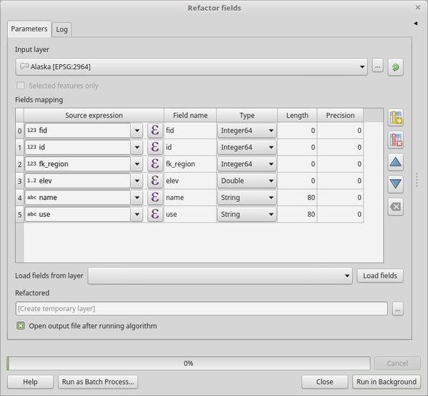
Fig. 24.178 Refactor fields dialog
Parametrai
Užrašas |
Pavadinimas |
Tipas |
Aprašymas |
|---|---|---|---|
Įvesties sluoksnis |
|
[vektorius: bet koks] |
The layer to modify |
Fields mapping |
|
[sąrašas] |
List of output fields with their definitions. The embedded table lists all the fields of the source layer and allows you to edit them:
For each of the fields you’d like to reuse, you need to fill the following options:
|
Refactored |
|
[toks pat, kaip įvestis] Numatytas: |
Išvesties sluoksnio specifikacija. Vienas iš:
Čia taipogi galima pakeisti failo koduotę. |


Išvestys
Užrašas |
Pavadinimas |
Tipas |
Aprašymas |
|---|---|---|---|
Refactored |
|
[toks pat, kaip įvestis] |
Output layer with refactored fields |
Pythono kodas
Algorithm ID: native:refactorfields
import processing
processing.run("algorithm_id", {parameter_dictionary})
algoritmo id rodomas, kai užvedate pelę virš algoritmo apdorojimo įrankinėje. parametrų žodynas teikia parametrų pavadinimus ir reikšmes. Daugiau informacijos apie tai, kaip vykdyti apdorojimo algoritmus Pythono konsolėje rasite skyriuje Using processing algorithms from the console.
24.1.29.11. Rename field
Renames an existing field from a vector layer.
The original layer is not modified. A new layer is generated where the attribute table contains the renamed field.
Taip pat žiūrėkite
Parametrai
Užrašas |
Pavadinimas |
Tipas |
Aprašymas |
|---|---|---|---|
Įvesties sluoksnis |
|
[vektorius: bet koks] |
Įvesties vektorinis sluoksnis |
Field to rename |
|
[tablefield: any] |
The field to be altered |
New field name |
|
[tekstas] |
The new field name |
Renamed |
|
[toks pat, kaip įvestis] Numatytas: |
Išvesties sluoksnio specifikacija. Vienas iš:
Čia taipogi galima pakeisti failo koduotę. |
Išvestys
Užrašas |
Pavadinimas |
Tipas |
Aprašymas |
|---|---|---|---|
Renamed |
|
[toks pat, kaip įvestis] |
Output layer with the renamed field |
Pythono kodas
Algorithm ID: native:renametablefield
import processing
processing.run("algorithm_id", {parameter_dictionary})
algoritmo id rodomas, kai užvedate pelę virš algoritmo apdorojimo įrankinėje. parametrų žodynas teikia parametrų pavadinimus ir reikšmes. Daugiau informacijos apie tai, kaip vykdyti apdorojimo algoritmus Pythono konsolėje rasite skyriuje Using processing algorithms from the console.
24.1.29.12. Retain fields
Takes a vector layer and generates a new one that retains only the selected fields. All other fields will be dropped.
Taip pat žiūrėkite
Parametrai
Užrašas |
Pavadinimas |
Tipas |
Aprašymas |
|---|---|---|---|
Įvesties sluoksnis |
|
[vektorius: bet koks] |
Įvesties vektorinis sluoksnis |
Fields to retain |
|
[lentelės laukas: bet koks] [sąrašas] |
List of fields to keep in the layer |
Retained fields |
|
[toks pat, kaip įvestis] Numatytas: |
Išvesties sluoksnio specifikacija. Vienas iš:
Čia taipogi galima pakeisti failo koduotę. |
Išvestys
Užrašas |
Pavadinimas |
Tipas |
Aprašymas |
|---|---|---|---|
Retained fields |
|
[toks pat, kaip įvestis] |
Output layer with the retained fields |
Pythono kodas
Algorithm ID: native:retainfields
import processing
processing.run("algorithm_id", {parameter_dictionary})
algoritmo id rodomas, kai užvedate pelę virš algoritmo apdorojimo įrankinėje. parametrų žodynas teikia parametrų pavadinimus ir reikšmes. Daugiau informacijos apie tai, kaip vykdyti apdorojimo algoritmus Pythono konsolėje rasite skyriuje Using processing algorithms from the console.
24.1.29.13. Text to float
Modifies the type of a given attribute in a vector layer, converting a
text attribute containing numeric strings into a numeric attribute
(e.g. ‚1‘ to 1.0).
The algorithm creates a new vector layer so the source one is not modified.
If the conversion is not possible the selected column will have
NULL values.
Parametrai
Užrašas |
Pavadinimas |
Tipas |
Aprašymas |
|---|---|---|---|
Įvesties sluoksnis |
|
[vektorius: bet koks] |
Įvesties vektorinis sluoksnis. |
Text attribute to convert to float |
|
[lentelės laukas: tekstas] |
The string field for the input layer that is to be converted to a float field. |
Float from text |
|
[toks pat, kaip įvestis] Numatytas: |
Nurodykite išvesties sluoksnį. Vienas iš:
Čia taipogi galima pakeisti failo koduotę. |
Išvestys
Užrašas |
Pavadinimas |
Tipas |
Aprašymas |
|---|---|---|---|
Float from text |
|
[toks pat, kaip įvestis] |
Output vector layer with the string field converted into a float field |
Pythono kodas
Algorithm ID: qgis:texttofloat
import processing
processing.run("algorithm_id", {parameter_dictionary})
algoritmo id rodomas, kai užvedate pelę virš algoritmo apdorojimo įrankinėje. parametrų žodynas teikia parametrų pavadinimus ir reikšmes. Daugiau informacijos apie tai, kaip vykdyti apdorojimo algoritmus Pythono konsolėje rasite skyriuje Using processing algorithms from the console.