Algorithms Include
Python Code Sample
import processing
processing.run("algorithm_id", {parameter_dictionary})
The algorithm id is displayed when you hover over the algorithm in the Processing Toolbox. The parameter dictionary provides the parameter NAMEs and values. See Using processing algorithms from the console for details on how to run processing algorithms from the Python console.
Output Types
Ścieżka
Zapisz do katalogu tymczasowego
Zapisz w katalogu
Pomiń wyjście
Zapisz do katalogu tymczasowego
Zapisz w katalogu
Plik
Zapisz do pliku tymczasowego
Zapisz do pliku…
Pomiń wyjście
Zapisz do pliku tymczasowego
Zapisz do pliku…
Warstwa
Create Temporary Layer (
TEMPORARY_OUTPUT)Zapisz do pliku…
Zapisz do GeoPackage…
Zapisz do tabeli bazy danych…
The file encoding can also be changed here.
Create Temporary Layer (
TEMPORARY_OUTPUT)Zapisz do pliku…
Zapisz do GeoPackage…
Zapisz do tabeli bazy danych…
Append to Layer…
The file encoding can also be changed here.
Pomiń wyjście
Create Temporary Layer (
TEMPORARY_OUTPUT)Zapisz do pliku…
Zapisz do GeoPackage…
Zapisz do tabeli bazy danych…
The file encoding can also be changed here.
Extent Dropdown
Available methods are:
Calculate from layer…: uses extent of a layer loaded in the current project
Calculate from layout map…: uses extent of a layout map item in the active project
Calculate from bookmark…: uses extent of a saved bookmark
Use map canvas extent
Draw on canvas: click and drag a rectangle delimiting the area to take into account
Enter the coordinates as
xmin, xmax, ymin, ymax
Geometric predicates
Geometric predicates are boolean functions used to determine the spatial relation a feature has with another by comparing whether and how their geometries share a portion of space.
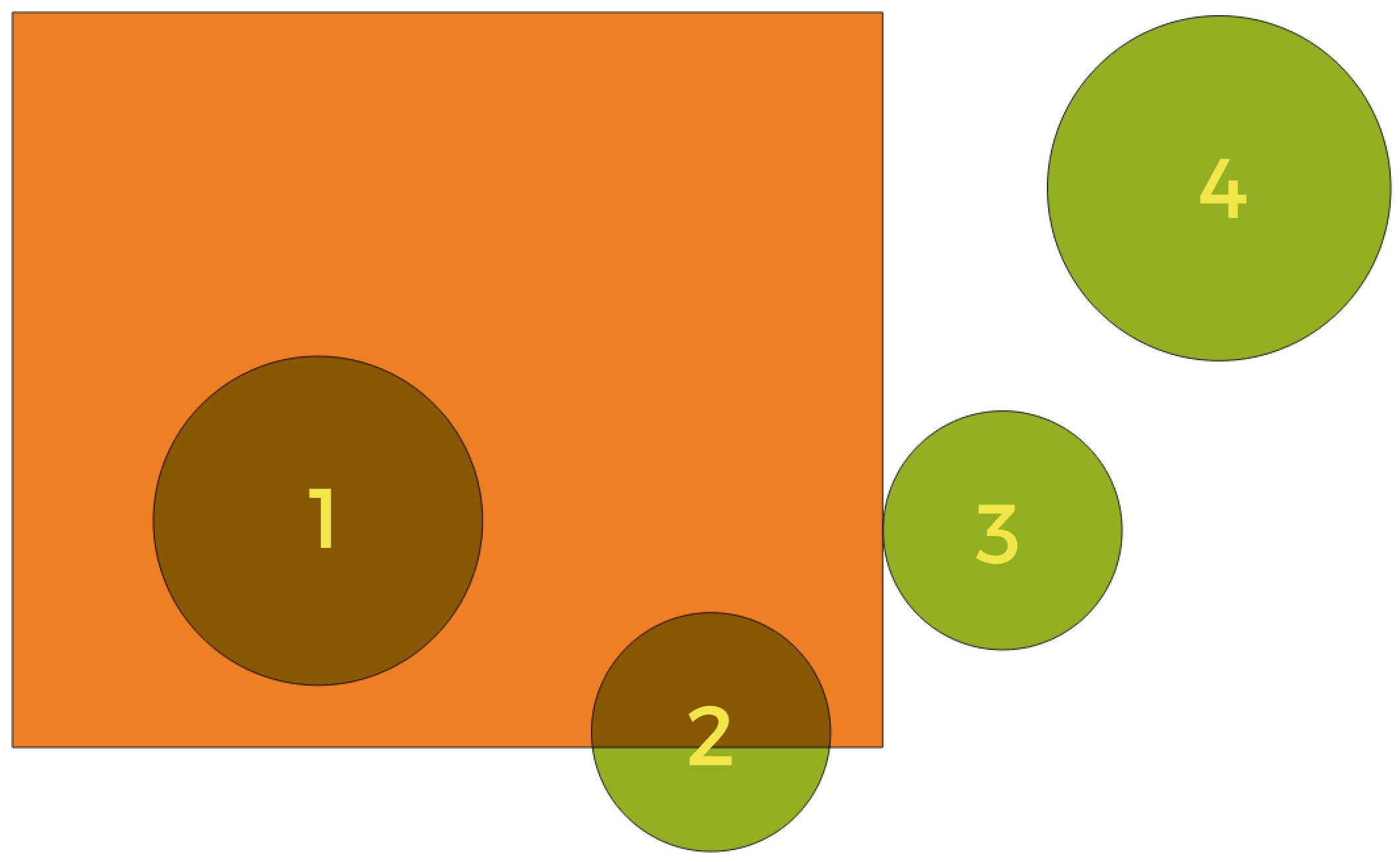
Looking for spatial relations between layers
Using the figure above, we are looking for the green circles by spatially comparing them to the orange rectangle feature. Available geometric predicates are:
- Przecina
Tests whether a geometry intersects another. Returns 1 (true) if the geometries spatially intersect (share any portion of space - overlap or touch) and 0 if they don’t. In the picture above, this will return circles 1, 2 and 3.
- Zawiera
Returns 1 (true) if and only if no points of b lie in the exterior of a, and at least one point of the interior of b lies in the interior of a. In the picture, no circle is returned, but the rectangle would be if you would look for it the other way around, as it contains circle 1 completely. This is the opposite of are within.
- Jest rozłączne
Returns 1 (true) if the geometries do not share any portion of space (no overlap, not touching). Only circle 4 is returned.
- Jest tożsame
Returns 1 (true) if and only if geometries are exactly the same. No circles will be returned.
- Dotyka
Tests whether a geometry touches another. Returns 1 (true) if the geometries have at least one point in common, but their interiors do not intersect. Only circle 3 is returned.
- Nachodzi
Tests whether a geometry overlaps another. Returns 1 (true) if the geometries share space, are of the same dimension, but are not completely contained by each other. Only circle 2 is returned.
- Are within
Tests whether a geometry is within another. Returns 1 (true) if geometry a is completely inside geometry b. Only circle 1 is returned.
- Cross
Returns 1 (true) if the supplied geometries have some, but not all, interior points in common and the actual crossing is of a lower dimension than the highest supplied geometry. For example, a line crossing a polygon will cross as a line (true). Two lines crossing will cross as a point (true). Two polygons cross as a polygon (false). In the picture, no circles will be returned.
Notes on algorithms
Ostrzeżenie
Geometry modification only
This operation modifies only the features geometry. The attribute values of the features are not modified, although properties such as area or length of the features will be modified by the overlay operation. If such properties are stored as attributes, those attributes will have to be manually updated.
Raster data types
Without user input (native)
0 — Byte (Eight bit unsigned integer (quint8))
1 — Int16 (Sixteen bit signed integer (qint16))
2 — UInt16 (Sixteen bit unsigned integer (quint16))
3 — Int32 (Thirty two bit signed integer (qint32))
4 — UInt32 (Thirty two bit unsigned integer (quint32))
5 — Float32 (Thirty two bit floating point (float))
6 — Float64 (Sixty four bit floating point (double))
7 — CInt16 (Complex Int16)
8 — CInt32 (Complex Int32)
9 — CFloat32 (Complex Float32)
10 — CFloat64 (Complex Float64)
11 — Int8 (Eight bit signed integer (qint8))
Available options depend on the GDAL version built with QGIS (see menu)
Without user input
0 — Byte (Eight bit unsigned integer (quint8))
1 — Int16 (Sixteen bit signed integer (qint16))
2 — UInt16 (Sixteen bit unsigned integer (quint16))
3 — UInt32 (Thirty two bit unsigned integer (quint32))
4 — Int32 (Thirty two bit signed integer (qint32))
5 — Float32 (Thirty two bit floating point (float))
6 — Float64 (Sixty four bit floating point (double))
7 — CInt16 (Complex Int16)
8 — CInt32 (Complex Int32)
9 — CFloat32 (Complex Float32)
10 — CFloat64 (Complex Float64)
11 — Int8 (Eight bit signed integer (qint8))
Available options depend on the GDAL version built with QGIS (see menu)
With user input
0 — Use Input Layer Data Type
1 — Byte (Eight bit unsigned integer (quint8))
2 — Int16 (Sixteen bit signed integer (qint16))
3 — UInt16 (Sixteen bit unsigned integer (quint16))
4 — UInt32 (Thirty two bit unsigned integer (quint32))
5 — Int32 (Thirty two bit signed integer (qint32))
6 — Float32 (Thirty two bit floating point (float))
7 — Float64 (Sixty four bit floating point (double))
8 — CInt16 (Complex Int16)
9 — CInt32 (Complex Int32)
10 — CFloat32 (Complex Float32)
11 — CFloat64 (Complex Float64)
12 — Int8 (Eight bit signed integer (qint8))
Available options depend on the GDAL version built with QGIS (see menu)
Resampling methods
0 — Najbliższy sąsiad
1 — Dwuliniowa (jądro 2x2)
2 — Sześcienna (jądro 4x4)
3 — Sześcienna krzywą B-sklejaną (jądro 4x4)
4 — Lanczosa (jądro 6x6)
5 — Średnia
6 — Tryb
7 — Maksimum
8 — Minimum
9 — Mediana
10 — Pierwszy kwartyl (Q1)
11 — Trzeciego kwartyla (Q3)
Vector field types
1 — Boolean
2 — Integer (32bit)
4 — Integer (64bit)
6 — Decimal (double)
9 — Integer list
9 — Integer (64bit) list
9 — Decimal (double) list
10 — Text (string)
11 — String list
12 — Binary Object (BLOB)
14 — Date
15 — Time
16 — Date & Time
2 — Integer list
4 — Integer (64bit) list
6 — Decimal (double) list
10 — String list
0 — Any other types