5.4. Lesson: 액션
Now that you have seen a default action in the previous lesson, it is time to define your own actions.
An action is something that happens when you click on a feature. It can add a lot of extra functionality to your map, allowing you to retrieve additional information about an object, for example. Assigning actions can add a whole new dimension to your map!
이 강의의 목표: 사용자 지정 액션을 추가하는 방법을 배우기.
In this lesson you will use the school_property layer you created previously. The sample data include photos of each of the three properties you digitized. What we are going to do is to associate each property with its image. Then we will create an action that will open the image for a property when clicking on the property.
5.4.1.  Follow Along: 이미지 용 항목 추가
The school_property layer has no way to associate an image with a
property yet. First we will create a field for this purpose.
Layer Properties 대화 창을 엽니다.
Fields 탭을 클릭합니다.
편집 모드를 엽니다.
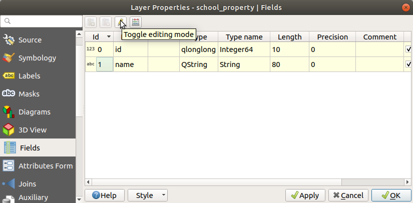
다음 새 열을 추가합니다.

다음 값을 입력합니다.

After the field has been created, move to the Attributes Form tab and select the
imagefield.Set Widget Type to Attachment:
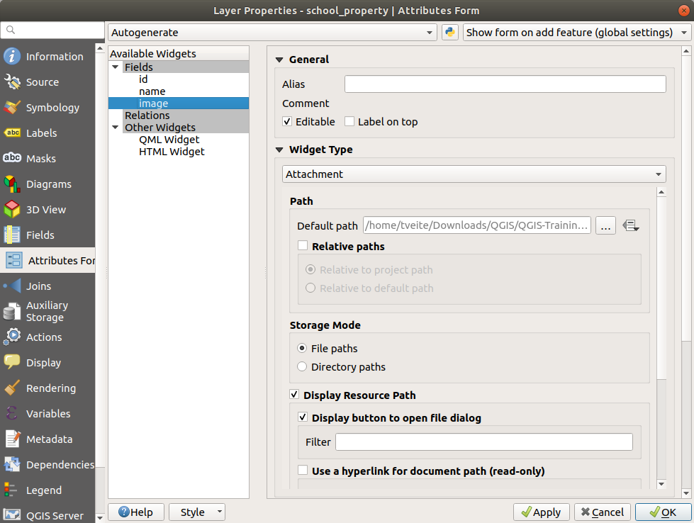
Click OK in the Layer Properties dialog.
Identify 도구를 사용해 school_property 레이어에 있는 세 피처 가운데 하나를 클릭합니다.
Since you are still in edit mode, the dialog should be active and look like this:

image 항목 옆의 … 탐색 버튼을 클릭하십시오.
Select the path for your image. The images are in
exercise_data/school_property_photos/and are named the same as the features they should be associated with.OK 를 클릭합니다.
이런 방법으로 모든 이미지들을 올바른 피처와 연계하십시오.
편집 내용을 저장하고 편집 모드를 끕니다.
5.4.2.  Follow Along: 액션 생성
Open the Actions tab for the school_property layer, and click on the
 Add a new action button.
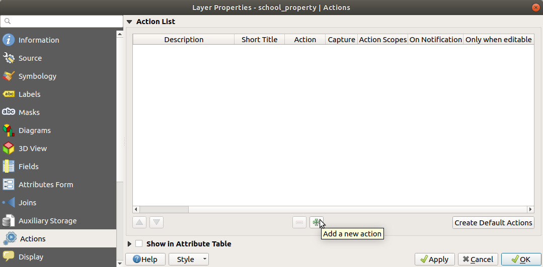
In the Add New Action dialog, enter the words
Show Imageinto the Description field: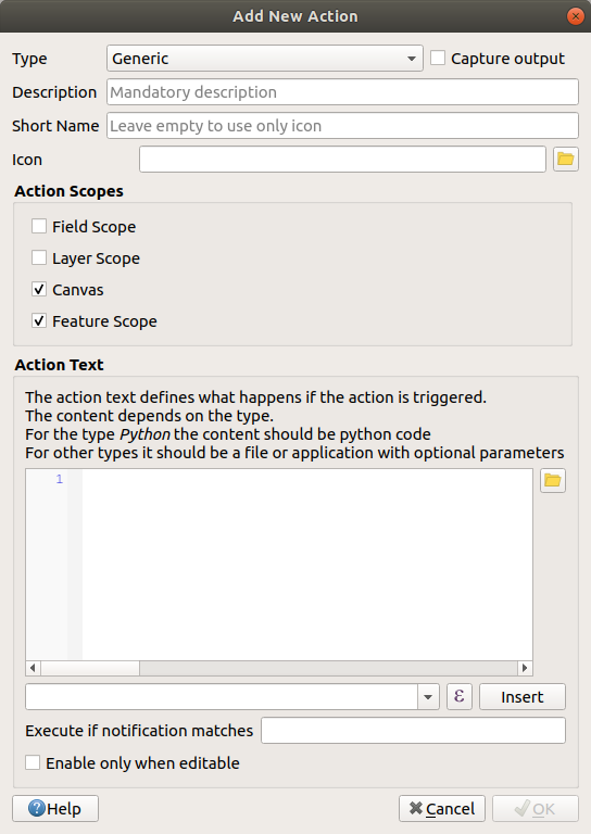
다음 단계는 사용자의 OS에 따라 달라지므로, 다음 가운데 적합한 지침을 선택하십시오.
윈도우
Type 드롭다운 메뉴를 클릭하고 Open 을 선택합니다.
우분투 리눅스
Under Action, write
eogfor the Gnome Image Viewer, or writedisplayto use ImageMagick. Remember to put a space after the command!macOS
Type 드롭다운 메뉴를 클릭하고 Mac 을 선택합니다.
Under Action, write
open. Remember to put a space after the command!
Now you can continue writing the command.
우리는 이미지를 열기를 원하고, QGIS는 이미지의 경로를 알고 있습니다. 이제 남은 것은 Action 에 이미지의 경로를 알려주는 일뿐입니다.
다음 목록에서 image 를 선택하십시오.
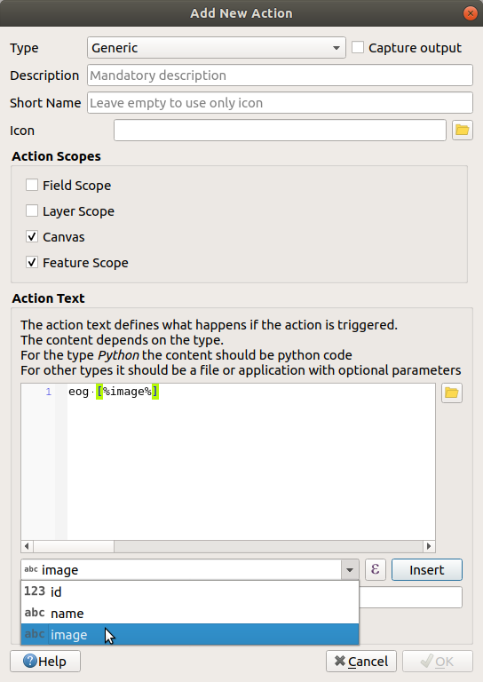
Click the Insert field button. QGIS will add the phrase
[% "image" %]in the Action Text field.Click the OK button to close the Add New Action dialog
Click OK to close the Layer Properties dialog
Now it is time to test the new action:
Click on the school_property layer in the Layers panel so that it is highlighted.
Find the
 Run feature action button (in the
Attributes Toolbar).
Run feature action button (in the
Attributes Toolbar).Click on the down arrow to the right of this button. There is only one action defined for this layer so far, which is the one you just created.

버튼을 클릭해서 도구를 활성화합니다.
이 도구를 이용해서, 학교 부지 세 곳 가운데 하나를 클릭합니다.
The image for that property should open.
5.4.3.  Follow Along: 인터넷 검색
Let’s say we are looking at the map and want to know more about the area that a farm is in. Suppose you know nothing of the area in question and want to find general information about it. Your first impulse, considering that you’re using a computer right now, would probably be to Google the name of the area. So let’s tell QGIS to do that automatically for us!
landuse 레이어의 속성 테이블을 엽니다.
We will be using the
namefield for each of our landuse areas to search Google.속성 테이블을 닫습니다.
Layer Properties 의 Actions 로 돌아갑니다.
Click on the Create Default Actions button to add a number of pre-defined actions.
Remove all the actions but the Open URL action with the short name Search Web using the
 Remove the selected action button below.
Double-click on the remaining action to edit it
Change the Description to
Google Search, and remove the content of the Short Name field.Make sure that Canvas is among the checked Action scopes.
다음 단계는 사용자의 OS에 따라 달라지므로, 다음 가운데 적합한 지침을 선택하십시오.
윈도우
Type 아래에 있는 Open 을 선택하면, 윈도우에 인터넷 익스플로러 같은 기본 브라우저에서 인터넷 주소를 열도록 명령합니다.
우분투 리눅스
Under Action, write
xdg-open. This will tell Ubuntu to open an Internet address in your default browser, such as Chrome or Firefox.macOS
Under Action, write
open. This will tell macOS to open an Internet address in your default browser, such as Safari.
Now you can continue writing the command
앞에 나열한 명령어 가운데 어떤 것을 이용하든, 이제 어떤 인터넷 주소를 열 것인지 알려줘야 합니다. 즉 구글 사이트로 가서 자동으로 지역명을 검색해야 합니다.
Usually when you use Google, you enter your search phrase into the Google Search bar. But in this case, you want your computer to do this for you. The way you tell Google to search for something (if you don’t want to use its search bar directly) is by giving your Internet browser the address
https://www.google.com/search?q=SEARCH_PHRASE, whereSEARCH_PHRASE`is what you want to search for. Since we don’t know what phrase to search for yet, we will just enter the first part (without the search phrase).In the Action field, write
https://www.google.com/search?q=. Remember to add a space after your initial command before writing this in!Now you want QGIS to tell the browser to tell Google to search for the value of
namefor any feature that you could click on.name 항목을 선택합니다.
Click Insert button:
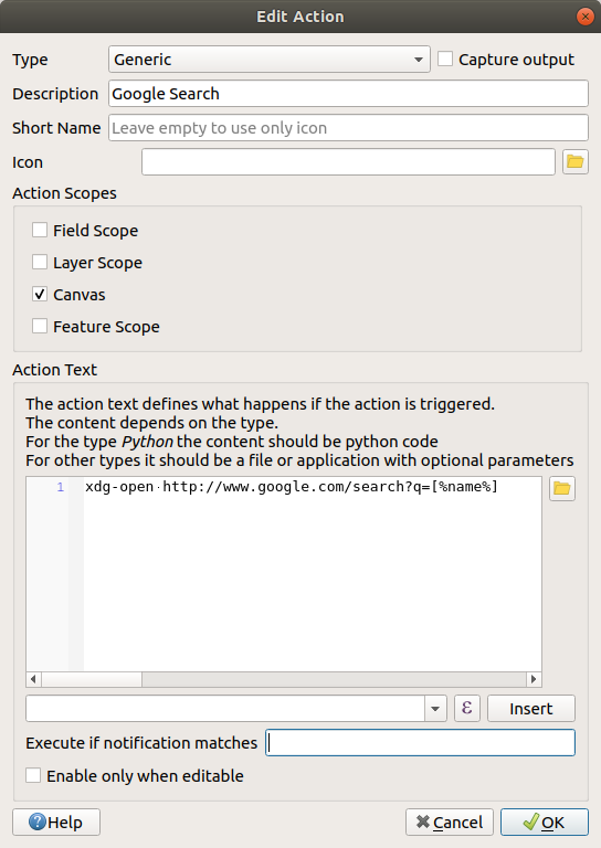
What this means is that QGIS is going to open the browser and send it to the address
https://www.google.com/search?q=[% "name" %].[% "name" %]tells QGIS to use the contents of thenamefield as the phrase to search for.So if, for example, the landuse area you click on is named
Marloth Nature Reserve, QGIS is going to send the browser tohttps://www.google.com/search?q=Marloth%20Nature%20Reserve, which will cause your browser to visit Google, which will in turn search for “Marloth Nature Reserve”.If you have not done so already, set everything up as explained above.
Click the OK button to close the Add New Action dialog
Click OK to close the Layer Properties dialog
이제 새로운 액션을 테스트해봅시다.
With the landuse layer active in the Layers panel, click on the down arrow to the right of the
 Run feature action button, and select the
only action (
Run feature action button, and select the
only action (Google Search) defined for this layer.Click on any landuse area you can see on the map. Your browser will now open, and will start a Google search for the place that is recorded as that area’s
namevalue.
참고
액션이 제대로 실행되지 않을 경우, 모든 명령어를 제대로 입력했는지 확인해보십시오. 이런 작업 시 오타가 흔하게 날 수 있습니다!
5.4.4.  Follow Along: QGIS 안에서 직접 웹페이지 열기
Above, you’ve seen how to open a webpage in an external browser. There are some shortcomings with this approach in that it adds an unknowable dependency – will the end-user have the software required to execute the action on their system? As you’ve seen, they don’t necessarily even have the same kind of base command for the same kind of action, if you don’t know which OS they will be using. With some OS versions, the above commands to open the browser might not work at all. This could be an insurmountable problem.
However, QGIS sits on top of the incredibly powerful and versatile Qt library. Also, QGIS actions can be arbitrary, tokenized (i.e. using variable information based on the contents of a field attribute) Python commands!
Now you will see how to use a python action to show a web page. It is the same general idea as opening a site in an external browser, but it requires no browser on the user’s system since it uses the Qt QWebView class (which is a webkit based html widget) to display the content in a pop-up window.
Let us use Wikipedia this time. So the URL you request will look like this:
https://wikipedia.org/wiki/SEARCH_PHRASE
레이어 액션을 생성하려면,
Layer Properties 대화 창을 열고 Actions 탭을 선택합니다.
새 액션을 위한 다음 속성들을 이용해서 해당 액션을 설정하십시오.
Type:
PythonDescription:
WikipediaScope:
Feature,CanvasAction Text:
from qgis.PyQt.QtCore import QUrl
from qgis.PyQt.QtWebKitWidgets import QWebView

myWV = QWebView(None)
myWV.load(QUrl('https://wikipedia.org/wiki/[%name%]'))
myWV.show()
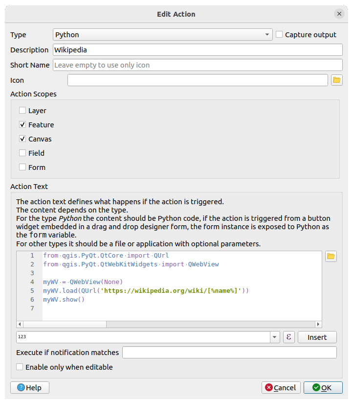
이 명령어에 대해 설명하겠습니다.
[%name%]will be replaced by the actual attribute value when the action is invoked (as before).The code simply creates a new
QWebViewinstance, sets its URL, and then callsshow()on it to make it visible as a window on the user’s desktop.
You could also use this approach to display an image without requiring that the users have a particular image viewer on their system.
Try to use the methods described above to load a Wikipedia page using the Wikipedia action you just created.
5.4.5. In Conclusion
액션을 사용하면 QGIS에서 동일한 맵을 보는 최종 사용자에게 유용한 추가 기능을 맵에 제공할 수 있습니다. 파이썬뿐만 아니라 모든 운영 체제에서 셸 명령을 사용할 수 있기 때문에 통합할 수 있는 기능 면에서 하늘이 한계입니다!
5.4.6. What’s Next?
모든 종류의 벡터 데이터 생성을 다 했으므로, 이제 데이터를 분석하여 문제를 해결하는 방법을 배울 겁니다. 이것이 다음 모듈의 주제입니다.