5. Advanced configuration
5.1. Logging
To log requests sent to the server, you have to set the following environment variable:
With the following variables the logging can be further customized:
5.2. Environment variables
You can configure some aspects of QGIS Server by setting environment variables.
According to the HTTP server and how you run QGIS Server, there are several ways to define these variables. This is fully described in Apache HTTP Server.
Name |
Description |
Default |
Services |
|---|---|---|---|
QGIS_OPTIONS_PATH |
Specifies the path to the directory with settings. It works the same way as
QGIS application |
‘’ |
All |
QGIS_PLUGINPATH |
Useful if you are using Python plugins for the server, this sets the folder that is searched for Python plugins. |
‘’ |
All |
QGIS_PROJECT_FILE |
The Note that you may also indicate a project stored in PostgreSQL, e.g.
|
‘’ |
All |
QGIS_SERVER_API_RESOURCES_DIRECTORY |
Base directory for all OGC API (such as OAPIF/WFS3) static resources (HTML templates, CSS, JS, …) |
depends on packaging |
WFS |
QGIS_SERVER_API_WFS3_MAX_LIMIT |
Maximum value for |
10000 |
WFS |
QGIS_SERVER_CACHE_DIRECTORY |
Specifies the network cache directory on the filesystem. |
|
All |
QGIS_SERVER_CACHE_SIZE |
Sets the network cache size in MB. |
50 MB |
All |
QGIS_SERVER_DISABLE_GETPRINT |
This is an option at the project level to improve project read time by disabling loading of layouts. Activating this option disables the QGIS WMS GetPrint request. Set this QGIS project flag to not load layouts. |
false |
WMS |
QGIS_SERVER_IGNORE_BAD_LAYERS |
“Bad” layers are layers that cannot be loaded. The default behavior of QGIS Server is to consider the project as not available if it contains a bad layer. The default behavior can be overridden by setting this variable to |
false |
All |
QGIS_SERVER_LANDING_PAGE_PROJECTS_DIRECTORIES |
Directories used by the landing page service to find .qgs and .qgz projects |
/qgis/server_projects_directories |
All |
QGIS_SERVER_LANDING_PAGE_PROJECTS_PG_CONNECTIONS |
PostgreSQL connection strings used by the landing page service to find projects |
/qgis/server_projects_pg_connections |
All |
QGIS_SERVER_LOG_FILE |
Specify path and filename. Make sure that server has proper permissions for writing to file. File should be created automatically, just send some requests to server. If it’s not there, check permissions. Warning QGIS_SERVER_LOG_FILE is deprecated since QGIS 3.4, use QGIS_SERVER_LOG_STDERR instead. File logging support will be removed in QGIS 4.0. |
‘’ |
All |
QGIS_SERVER_LOG_LEVEL |
Specify desired log level. Available values are:
|
0 |
All |
QGIS_SERVER_LOG_PROFILE |
Add detailed profile information to the logs, only effective when QGIS_SERVER_LOG_LEVEL=0 |
/qgis/server_log_profile |
All |
QGIS_SERVER_LOG_STDERR |
Activate logging to stderr. This variable has no effect when
|
false |
All |
QGIS_SERVER_MAX_THREADS |
Number of threads to use when parallel rendering is activated. If value is |
-1 |
All |
QGIS_SERVER_OVERRIDE_SYSTEM_LOCALE |
Sets LOCALE to be used by QGIS server. The default value is empty (no override). Example: |
‘’ |
All |
QGIS_SERVER_PARALLEL_RENDERING |
Activates parallel rendering for WMS GetMap requests. It’s disabled (
|
false |
WMS |
QGIS_SERVER_SHOW_GROUP_SEPARATOR |
Defines whether a group separator (e.g. thousand separator) should be used for
numeric values (e.g. in GetFeatureInfo responses). The default value is
|
false |
WMS |
QGIS_SERVER_TRUST_LAYER_METADATA |
This is an option at the project level to improve project read time by using the vector layer extents defined in the project metadata and disabling the check for PostgreSQL/PostGIS layer primary key uniqueness. Trusting layer metadata can be forced by setting this variable to Do not use it if layers’ extent is not fixed during the project’s use. |
false |
All |
QGIS_SERVER_WMS_MAX_HEIGHT / QGIS_SERVER_WMS_MAX_WIDTH |
Maximum height/width for a WMS request. The most conservative between this and the project one is used.
If the value is |
-1 |
WMS |
QUERY_STRING |
The query string, normally passed by the web server. This variable can be useful while testing QGIS server binary from the command line. For example for testing a GetCapabilities request on the command line to a project that also requires a PostgreSQL connection defined in a pg_service.conf file: PGSERVICEFILE=/etc/pg_service.conf \
QUERY_STRING="MAP=/home/qgis/projects/world.qgs&SERVICE=WMS&REQUEST=GetCapabilities" \
/usr/lib/cgi-bin/qgis_mapserv.fcgi
The result should be either the content of the GetCapabilities response or, if something is wrong, an error message. |
‘’ |
All |
5.3. Settings summary
When QGIS Server is starting, you have a summary of all configurable parameters thanks to environment variables. Moreover, the value currently used and the origin is also displayed.
For example with spawn-fcgi:
export QGIS_OPTIONS_PATH=/home/user/.local/share/QGIS/QGIS3/profiles/default/
export QGIS_SERVER_LOG_STDERR=1
export QGIS_SERVER_LOG_LEVEL=2
spawn-fcgi -f /usr/lib/cgi-bin/qgis_mapserv.fcgi -s /tmp/qgisserver.sock -U www-data -G www-data -n

 QGIS Server Settings:

   - QGIS_OPTIONS_PATH / '' (Override the default path for user configuration): '/home/user/.local/share/QGIS/QGIS3/profiles/default/' (read from ENVIRONMENT_VARIABLE)

   - QGIS_SERVER_PARALLEL_RENDERING / '/qgis/parallel_rendering' (Activate/Deactivate parallel rendering for WMS getMap request): 'true' (read from INI_FILE)

   - QGIS_SERVER_MAX_THREADS / '/qgis/max_threads' (Number of threads to use when parallel rendering is activated): '4' (read from INI_FILE)

   - QGIS_SERVER_LOG_LEVEL / '' (Log level): '2' (read from ENVIRONMENT_VARIABLE)

   - QGIS_SERVER_LOG_STDERR / '' (Activate/Deactivate logging to stderr): '1' (read from ENVIRONMENT_VARIABLE)

   - QGIS_PROJECT_FILE / '' (QGIS project file): '' (read from DEFAULT_VALUE)

   - MAX_CACHE_LAYERS / '' (Specify the maximum number of cached layers): '100' (read from DEFAULT_VALUE)

   - QGIS_SERVER_CACHE_DIRECTORY / '/cache/directory' (Specify the cache directory): '/root/.local/share/QGIS/QGIS3/profiles/default/cache' (read from DEFAULT_VALUE)

   - QGIS_SERVER_CACHE_SIZE / '/cache/size' (Specify the cache size): '52428800' (read from INI_FILE)

 Ini file used to initialize settings: /home/user/.local/share/QGIS/QGIS3/profiles/default/QGIS/QGIS3.ini
In this particular case, we know that QGIS_SERVER_MAX_THREADS and QGIS_SERVER_PARALLEL_RENDERING values are read from the ini file found in QGIS_OPTIONS_PATH directory (which is defined through an environment variable). The corresponding entries in the ini file are /qgis/max_threads and /qgis/parallel_rendering and their values are true and 4 threads.
5.4. Short name for layers, groups and project
A number of elements have both a <Name> and a <Title>.
The Name is a text string used for machine-to-machine
communication while the Title is for the benefit of humans.
For example, a dataset might have the descriptive Title “Maximum Atmospheric Temperature” and be requested using the abbreviated Name “ATMAX”. The user can set the title for layers, groups and projects.
OWS name is based on the name used in the layer tree. This name is more a label for humans than a name for machine-to-machine communication. You can set a Short name for layers, groups or projects, to be used by QGIS Server as the layer identification name (in LAYERS parameter for instance ).
You can set title, short name and abstract for:
Layers: right-click on a layer and choose .
Groups: right-click on a group and select Set Group WMS data
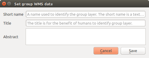
Fig. 5.5 Set group WMS data dialog
Project: go to .
5.5. Connection to service file
In order to make apache aware of the PostgreSQL service file (see the
PostgreSQL Service connection file section) you need to make
your *.conf file look like:
SetEnv PGSERVICEFILE /home/web/.pg_service.conf

<Directory "/home/web/apps2/bin/">
  AllowOverride None
.....
5.6. Add fonts to your linux server
Keep in mind that you may use QGIS projects that point to fonts that may not exist by default on other machines. This means that if you share the project, it may look different on other machines (if the fonts don’t exist on the target machine).
In order to ensure this does not happen you just need to install the missing fonts on the target machine. Doing this on desktop systems is usually trivial (double clicking the fonts).
For linux, if you don’t have a desktop environment installed (or you prefer the command line) you need to:
On Debian based systems:
sudo su
mkdir -p /usr/local/share/fonts/truetype/myfonts && cd /usr/local/share/fonts/truetype/myfonts

# copy the fonts from their location
cp /fonts_location/* .

chown root *
cd .. && fc-cache -f -v
On Fedora based systems:
sudo su
mkdir /usr/share/fonts/myfonts && cd /usr/share/fonts/myfonts

# copy the fonts from their location
cp /fonts_location/* .

chown root *
cd .. && fc-cache -f -v