` `
Plugin Raster Analisis Terrain
 The Raster Terrain Analysis Plugin can be used to calculate the
slope, aspect, hillshade, ruggedness index and relief for digital elevation
models (DEM). It is very simple to handle and provides an intuitive graphical
user interface for creating new raster layers (see Figure_raster_terrain).
The Raster Terrain Analysis Plugin can be used to calculate the
slope, aspect, hillshade, ruggedness index and relief for digital elevation
models (DEM). It is very simple to handle and provides an intuitive graphical
user interface for creating new raster layers (see Figure_raster_terrain).
Deskripsi dari analisis:
Lereng: Menghitung sudut kemiringan untuk setiap sel dalam derajat (berdasarkan urutan pertama estimasi derivatif).
Aspek: Eksposisi (dimulai dengan 0 untuk arah utara, dalam derajat berlawanan jarum jam).
- Hillshade: Creates a shaded map using light and shadow to provide a more three-dimensional appearance for a shaded relief map. The output map is a Single band gray reflecting the gray value of the pixels.
Indeks Ketidakrataan: Sebuah pengukuran kuantitatif dari medan heterogenitas seperti yang dijelaskan oleh Riley et al. (1999). Hal ini dihitung untuk setiap lokasi, dengan meringkas perubahan elevasi dalam kisi 3x3 piksel.
- Relief: Creates a shaded relief map from digital elevation data. Implemented is a method to choose the elevation colors by analysing the frequency distribution. The output map is a multiband color with three bands reflecting the RGB values of the shaded relief.
Plugin Raster Pemodelan Terrain (perhitungan kemiringan)
Menggunakan plugin
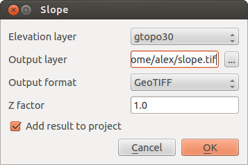
- Start QGIS and load the gtopo30 raster layer from the GRASS sample location.
Muat plugin Raster Analisis Terrain plugin di Pengelola Plugin (lihat Bagian The Plugins Dialog).
- Select an analysis method from the menu (e.g., Raster ‣ Terrain Analysis ‣ Slope). The Slope dialog appears as shown in Figure_raster_terrain.
Spesifikasi keluaran berkas path dan keluaran tipe berkas:
Klik [OK].