` `
QGIS Standalone Browser
QGIS Browser is available as a standalone application and as a panel in QGIS Desktop. It lets you easily navigate in your filesystem and manage geodata. You can have access to common vector files (e.g., ESRI shapefiles or MapInfo files), databases (e.g., PostGIS, Oracle, SpatiaLite or MS SQL Spatial) and OWS/WCS|WMS|WFS connections. You can also view GRASS data (to get the data into QGIS, see GRASS GIS Integration).
QGIS Browser Panel description is available at The Browser Panel section so only the standalone browser is treated below.
Like the Browser panel, the standalone Browser helps you navigate through your filesystem and manage geodata. It also helps you preview or create them and open them in a QGIS project by drag-and-drop.
Mulai Penjelajah QGIS

 Start the QGIS Browser using the Start menu or desktop shortcut.
 The QGIS Browser is available from your Applications folder.
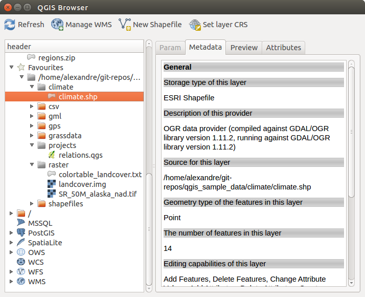
QGIS Browser as a standalone application
In figure_browser_standalone_metadata, you can see the enhanced functionality of the standalone QGIS Browser. The Param tab provides the details of your connection-based datasets, like PostGIS or MSSQL Spatial. The Metadata tab contains general information about the file (see Metadata Properties). With the Preview tab, you can have a look at your files without importing them into your QGIS project. It’s also possible to preview the attributes of your files in the Attributes tab.