Importante
A tradução é um esforço comunitário você pode contribuir. Esta página está atualmente traduzida em 72.07%.
24.1.27. Vector overlay
24.1.27.1. Clip
Clips a vector layer using the features of an additional polygon layer.
Only the parts of the features in the input layer that fall within the polygons of the overlay layer will be added to the resulting layer.
Aviso
Apenas modificação de geometria
Esta operação modifica apenas a geometria das feições. Os valores de atributo das feições não são modificados, embora propriedades como área ou comprimento das feições sejam modificadas pela operação de sobreposição. Se tais propriedades forem armazenadas como atributos, esses atributos terão que ser atualizados manualmente.
This algorithm uses spatial indexes on the providers, prepared geometries and apply a clipping operation if the geometry isn’t wholly contained by the mask geometry.
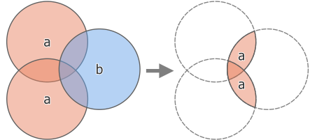
Fig. 24.162 Clipping operation between a two-feature input layer ‘a’ and a single feature overlay layer ‘b’ (left) - resulting in a new layer with the modified ‘a’ features (right)
 Allows features in-place modification 1 de ponto, linha e características poligonais.
Default menu:
Ver também
Parâmetros
Etiqueta |
Nome |
Tipo |
Descrição |
|---|---|---|---|
Camada de entrada |
|
[vector: geometry] |
Layer containing the features to be clipped |
Overlay layer |
|
[vetor: polígono] |
Layer containing the clipping features |
Clipped |
|
[o mesmo que entrada] Padrão: |
Specify the layer to contain the features from the input layer that are inside the overlay (clipping) layer. One of:
A codificação do arquivo também pode ser alterada aqui. |
Saídas
Etiqueta |
Nome |
Tipo |
Descrição |
|---|---|---|---|
Clipped |
|
[o mesmo que entrada] |
Layer containing features from the input layer split by the overlay layer. |
Código Python
Algorithm ID: native:clip
import processing
processing.run("algorithm_id", {parameter_dictionary})
O id do algoritmo é exibido quando você passa o mouse sobre o algoritmo na Caixa de ferramentas de processamento. O dicionário de parâmetros fornece os nomes e valores dos parâmetros. Veja Usando os algoritmos do processamento a partir do Terminal Python. para detalhes sobre como executar algoritmos de processamento a partir do console Python.
24.1.27.2. Diferença
Extracts features from the input layer that don’t fall within the boundaries of the overlay layer.
Input layer features that partially overlap the overlay layer feature(s) are split along the boundary of those feature(s) and only the portions outside the overlay layer features are retained.
Aviso
Apenas modificação de geometria
Esta operação modifica apenas a geometria das feições. Os valores de atributo das feições não são modificados, embora propriedades como área ou comprimento das feições sejam modificadas pela operação de sobreposição. Se tais propriedades forem armazenadas como atributos, esses atributos terão que ser atualizados manualmente.
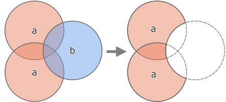
Fig. 24.163 Difference operation between a two-features input layer ‘a’ and a single feature overlay layer ‘b’ (left) - resulting in a new layer with the modified ‘a’ features (right)
Allows features in-place modification 1 de ponto, linha e características poligonais.
Default menu:
Ver também
Parâmetros
Parâmetros básicos
Etiqueta |
Nome |
Tipo |
Descrição |
|---|---|---|---|
Camada de entrada |
|
[vector: geometry] |
Layer to extract (parts of) features from. |
Overlay layer |
|
[vector: geometry] |
Layer containing the geometries that will be subtracted from the input layer geometries. It is expected to have at least as many dimensions (point: 0D, line: 1D, polygon: 2D, volume: 3D) as the input layer geometries. |
Diferença |
|
[o mesmo que entrada] Padrão: |
Specify the layer to contain the (parts of) features from the input layer that are not inside the overlay layer. One of:
A codificação do arquivo também pode ser alterada aqui. |
Parâmetros avançados
Etiqueta |
Nome |
Tipo |
Descrição |
|---|---|---|---|
Grid size Opcional |
|
[numeric: double] Padrão: Não definido |
If provided, the input geometries are snapped to a grid of the given size, and the result vertices are computed on that same grid. |
Saídas
Etiqueta |
Nome |
Tipo |
Descrição |
|---|---|---|---|
Diferença |
|
[o mesmo que entrada] |
Camada contendo (partes das) feições da camada de entrada que não se sobrepõe à camada de sobreposição. |
Código Python
Algorithm ID: native:difference
import processing
processing.run("algorithm_id", {parameter_dictionary})
O id do algoritmo é exibido quando você passa o mouse sobre o algoritmo na Caixa de ferramentas de processamento. O dicionário de parâmetros fornece os nomes e valores dos parâmetros. Veja Usando os algoritmos do processamento a partir do Terminal Python. para detalhes sobre como executar algoritmos de processamento a partir do console Python.
24.1.27.3. Difference (multiple)
Extracts features from the input layer that fall completely outside or only partially overlap the features from any of the overlay layer(s).
For each overlay layer the difference is calculated between the result of all previous difference operations and this overlay layer. Input layer features that partially overlap feature(s) in the overlay layer are split along those features’ boundary and only the portions outside the overlay layer features are retained.
Aviso
Apenas modificação de geometria
Esta operação modifica apenas a geometria das feições. Os valores de atributo das feições não são modificados, embora propriedades como área ou comprimento das feições sejam modificadas pela operação de sobreposição. Se tais propriedades forem armazenadas como atributos, esses atributos terão que ser atualizados manualmente.
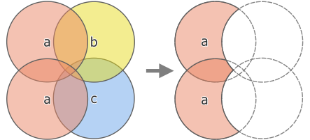
Fig. 24.164 Difference operation between a two-feature input layer ‘a’ and single feature overlay layers ‘b’ and ‘c’ (left) - resulting in a new layer with the modified ‘a’ features (right)
Ver também
Parâmetros
Etiqueta |
Nome |
Tipo |
Descrição |
|---|---|---|---|
Camada de entrada |
|
[vector: geometry] |
Layer to extract (parts of) features from. |
Overlay layers |
|
[vector: geometry] [list] |
List of layers containing the geometries that will be subtracted from the input layer geometries. They are expected to have at least as many dimensions (point: 0D, line: 1D, polygon: 2D, volume: 3D) as the input layer geometries. |
Diferença |
|
[o mesmo que entrada] Padrão: |
Specify the layer to contain the (parts of) features from the input layer that do not overlap features of the overlay layers. One of:
A codificação do arquivo também pode ser alterada aqui. |
Saídas
Etiqueta |
Nome |
Tipo |
Descrição |
|---|---|---|---|
Diferença |
|
[o mesmo que entrada] |
Layer containing (parts of) features from the input layer not overlapping features from the overlay layers. |
Código Python
Algorithm ID: native:multidifference
import processing
processing.run("algorithm_id", {parameter_dictionary})
O id do algoritmo é exibido quando você passa o mouse sobre o algoritmo na Caixa de ferramentas de processamento. O dicionário de parâmetros fornece os nomes e valores dos parâmetros. Veja Usando os algoritmos do processamento a partir do Terminal Python. para detalhes sobre como executar algoritmos de processamento a partir do console Python.
24.1.27.4. Extract/clip by extent
Creates a new vector layer that only contains features which fall within a specified extent. Any features which intersect the extent will be included by default.
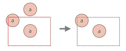
Fig. 24.165 Operação de extração entre uma camada de entrada de três características “a” e uma extensão tracejada (esquerda) - características resultantes com extensão tracejada para referência (direita)
Optionally, feature geometries can also be clipped to the extent.
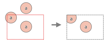
Fig. 24.166 Operação de extração entre uma camada de entrada de três características “a” e uma extensão tracejada (esquerda) - características resultantes com extensão tracejada para referência (direita)
Ver também
Parâmetros
Etiqueta |
Nome |
Tipo |
Descrição |
|---|---|---|---|
Camada de entrada |
|
[vector: geometry] |
Layer to extract (parts of) features from. |
Extensão (xmin, xmax, ymin, ymax) |
|
[extensão] |
Extent for clipping. Os métodos disponíveis são:
|
Clip features to extent |
|
[boleano] Padrão: Falso |
If checked, the geometries will be clipped to the extent chosen instead of taking the whole geometry as output. Moreover, output geometries will be automatically converted to multi geometries to ensure uniform output types. |
Extraído |
|
[o mesmo que entrada] Padrão: |
Specify the layer to contain the features from the input layer that are inside the clip extent. One of:
A codificação do arquivo também pode ser alterada aqui. |
Saídas
Etiqueta |
Nome |
Tipo |
Descrição |
|---|---|---|---|
Extraído |
|
[o mesmo que entrada] |
Layer containing the clipped features. |
Código Python
Algorithm ID: native:extractbyextent
import processing
processing.run("algorithm_id", {parameter_dictionary})
O id do algoritmo é exibido quando você passa o mouse sobre o algoritmo na Caixa de ferramentas de processamento. O dicionário de parâmetros fornece os nomes e valores dos parâmetros. Veja Usando os algoritmos do processamento a partir do Terminal Python. para detalhes sobre como executar algoritmos de processamento a partir do console Python.
24.1.27.5. Interseção
Extrai as partes das feições da camada de entrada que se sobrepõem aàs feições na camada de sobreposição.
As feições na camada de interseção são atribuídas aos atributos das feições sobrepostas das camadas de entrada e de sobreposição.
Aviso
Apenas modificação de geometria
Esta operação modifica apenas a geometria das feições. Os valores de atributo das feições não são modificados, embora propriedades como área ou comprimento das feições sejam modificadas pela operação de sobreposição. Se tais propriedades forem armazenadas como atributos, esses atributos terão que ser atualizados manualmente.
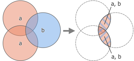
Fig. 24.167 Intersection operation between a two-feature input layer ‘a’ and a single feature overlay layer ‘b’ (left) - overlapping areas become a new two-feature layer with both layers’ attributes (right)
Default menu:
Aviso
This algorithm drops existing primary keys or FID values and regenerates them in output layers.
Ver também
Parâmetros
Parâmetros básicos
Etiqueta |
Nome |
Tipo |
Descrição |
|---|---|---|---|
Camada de entrada |
|
[vector: geometry] |
Layer to extract (parts of) features from. |
Overlay layer |
|
[vector: geometry] |
Layer containing the features to check for overlap. Its features’ geometry is expected to have at least as many dimensions (point: 0D, line: 1D, polygon: 2D, volume: 3D) as the input layer’s. |
Input fields to keep (leave empty to keep all fields) Opcional |
|
[campo da tabela: qualquer][list] Padrão: Não definido |
Field(s) of the input layer to keep in the output. If no fields are chosen all fields are taken. |
Overlay fields to keep (leave empty to keep all fields) Opcional |
|
[campo da tabela: qualquer][list] Padrão: Não definido |
Field(s) of the overlay layer to keep in the output. If no fields are chosen all fields are taken. Duplicate field names will be appended a count suffix to avoid collision. |
Intersecção |
|
[o mesmo que entrada] Padrão: |
Specify the layer to contain (the parts of) the features from the input layer that overlap one or more features from the overlay layer. One of:
A codificação do arquivo também pode ser alterada aqui. |
Parâmetros avançados
Etiqueta |
Nome |
Tipo |
Descrição |
|---|---|---|---|
Overlay fields prefix Opcional |
|
[string] |
Add a prefix to identify fields of the overlay layer. Duplicate field names will be appended a count suffix to avoid collision. |
Grid size Opcional |
|
[numeric: double] Padrão: Não definido |
If provided, the input geometries are snapped to a grid of the given size, and the result vertices are computed on that same grid. |
Saídas
Etiqueta |
Nome |
Tipo |
Descrição |
|---|---|---|---|
Intersecção |
|
[o mesmo que entrada] |
Layer containing (parts of) features from the input layer that overlap the overlay layer. |
Código Python
Algorithm ID: native:intersection
import processing
processing.run("algorithm_id", {parameter_dictionary})
O id do algoritmo é exibido quando você passa o mouse sobre o algoritmo na Caixa de ferramentas de processamento. O dicionário de parâmetros fornece os nomes e valores dos parâmetros. Veja Usando os algoritmos do processamento a partir do Terminal Python. para detalhes sobre como executar algoritmos de processamento a partir do console Python.
24.1.27.6. Intersection (multiple)
Extracts the overlapping portions of features in the input and all overlay layers.
Features in the output layer are assigned the attributes of the overlapping features from both the input and overlay layers.
Aviso
Apenas modificação de geometria
Esta operação modifica apenas a geometria das feições. Os valores de atributo das feições não são modificados, embora propriedades como área ou comprimento das feições sejam modificadas pela operação de sobreposição. Se tais propriedades forem armazenadas como atributos, esses atributos terão que ser atualizados manualmente.
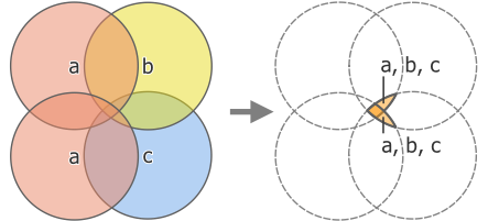
Fig. 24.168 Intersection operation between a two-feature input layer ‘a’ and single feature overlay layers ‘b’ and ‘c’ (left) - overlapping areas become a new two-feature layer with all layers’ attributes (right)
Aviso
This algorithm drops existing primary keys or FID values and regenerate them in output layers.
Ver também
Parâmetros
Parâmetros básicos
Etiqueta |
Nome |
Tipo |
Descrição |
|---|---|---|---|
Camada de entrada |
|
[vector: geometry] |
Layer to extract (parts of) features from. |
Overlay layers |
|
[vector: geometry] [list] |
Layers containing the features to check for overlap. The features’ geometry is expected to have at least as many dimensions (point: 0D, line: 1D, polygon: 2D, volume: 3D) as the input layer’s. |
Parâmetros avançados
Etiqueta |
Nome |
Tipo |
Descrição |
|---|---|---|---|
Overlay fields prefix Opcional |
|
[string] |
Add a prefix to identify fields of the overlay layers. Duplicate field names will be appended a count suffix to avoid collision. |
Saídas
Etiqueta |
Nome |
Tipo |
Descrição |
|---|---|---|---|
Intersecção |
|
[o mesmo que entrada] |
Layer containing (parts of) features from the input layer that overlap all the overlay layers. |
Código Python
Algorithm ID: native:multiintersection
import processing
processing.run("algorithm_id", {parameter_dictionary})
O id do algoritmo é exibido quando você passa o mouse sobre o algoritmo na Caixa de ferramentas de processamento. O dicionário de parâmetros fornece os nomes e valores dos parâmetros. Veja Usando os algoritmos do processamento a partir do Terminal Python. para detalhes sobre como executar algoritmos de processamento a partir do console Python.
24.1.27.7. Interseções de linha
Cria feições de ponto onde as linhas das duas camadas se cruzam.
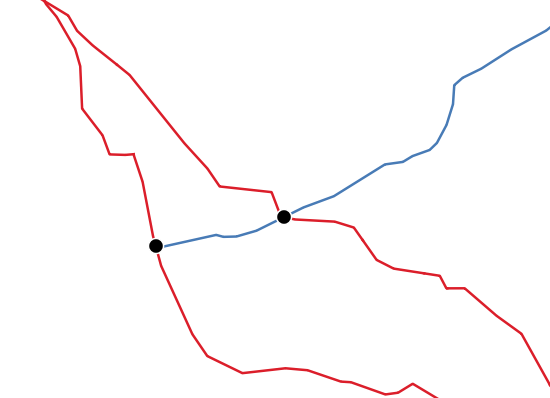
Fig. 24.169 Pontos de interseção
Default menu:
Aviso
This algorithm drops existing primary keys or FID values and regenerate them in output layers.
Parâmetros
Parâmetros básicos
Etiqueta |
Nome |
Tipo |
Descrição |
|---|---|---|---|
Camada de entrada |
|
[vetor: linha] |
Input line layer. |
camada de interseção* |
|
[vetor: linha] |
Layer to use to find line intersections. |
Input fields to keep (leave empty to keep all fields) Opcional |
|
[campo da tabela: qualquer][list] Padrão: Não definido |
Field(s) of the input layer to keep in the output. If no fields are chosen all fields are taken. |
Intersect fields to keep (leave empty to keep all fields) Opcional |
|
[campo da tabela: qualquer][list] Padrão: Não definido |
Field(s) of the intersect layer to keep in the output. If no fields are chosen all fields are taken. Duplicate field names will be appended a count suffix to avoid collision. |
Intersecção |
|
[vetor: ponto] Padrão: |
Specify the layer to contain the intersection points of the lines from the input and overlay layers. One of:
A codificação do arquivo também pode ser alterada aqui. |
Parâmetros avançados
Etiqueta |
Nome |
Tipo |
Descrição |
|---|---|---|---|
Intersect fields prefix Opcional |
|
[string] |
Add a prefix to identify fields of the intersect layer. |
Saídas
Etiqueta |
Nome |
Tipo |
Descrição |
|---|---|---|---|
Interseções |
|
[vetor: ponto] |
Point vector layer of the lines intersections, with both layers’ attributes. |
Código Python
Algorithm ID: native:lineintersections
import processing
processing.run("algorithm_id", {parameter_dictionary})
O id do algoritmo é exibido quando você passa o mouse sobre o algoritmo na Caixa de ferramentas de processamento. O dicionário de parâmetros fornece os nomes e valores dos parâmetros. Veja Usando os algoritmos do processamento a partir do Terminal Python. para detalhes sobre como executar algoritmos de processamento a partir do console Python.
24.1.27.8. Split with lines
Splits the lines or polygons in one layer using the lines or polygon rings in another layer to define the breaking points. Intersection between geometries in both layers are considered as split points.
Output will contain multi geometries for split features.
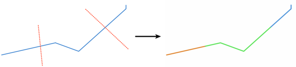
Fig. 24.170 Linhas divididas
permite features in-place modification 1.
Aviso
This algorithm drops existing primary keys or FID values and regenerate them in output layers.
Parâmetros
Etiqueta |
Nome |
Tipo |
Descrição |
|---|---|---|---|
Camada de entrada |
|
[vetor: linha, polígono] |
Camada que contém as linhas ou polígonos a serem divididos. |
Split layer |
|
[vetor: linha, polígono] |
Layer whose lines or rings are used to define the breaking points. |
Dividir |
|
[o mesmo que entrada] Padrão: |
Specify the layer to contain the split (in case they are intersected by a line in the split layer) line/polygon features from the input layer. One of:
A codificação do arquivo também pode ser alterada aqui. |
Saídas
Etiqueta |
Nome |
Tipo |
Descrição |
|---|---|---|---|
Dividir |
|
[o mesmo que entrada] |
Output vector layer with split lines or polygons from input layer. |
Código Python
Algorithm ID: native:splitwithlines
import processing
processing.run("algorithm_id", {parameter_dictionary})
O id do algoritmo é exibido quando você passa o mouse sobre o algoritmo na Caixa de ferramentas de processamento. O dicionário de parâmetros fornece os nomes e valores dos parâmetros. Veja Usando os algoritmos do processamento a partir do Terminal Python. para detalhes sobre como executar algoritmos de processamento a partir do console Python.
24.1.27.9. Diferença simétrica
Creates a layer containing features from both the input and overlay layers but with the overlapping areas between the two layers removed.
The attribute table of the symmetrical difference layer contains attributes and fields from both the input and overlay layers.
Aviso
Apenas modificação de geometria
Esta operação modifica apenas a geometria das feições. Os valores de atributo das feições não são modificados, embora propriedades como área ou comprimento das feições sejam modificadas pela operação de sobreposição. Se tais propriedades forem armazenadas como atributos, esses atributos terão que ser atualizados manualmente.
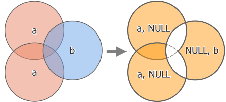
Fig. 24.171 Symmetrical difference operation between a two-features input layer ‘a’ and a single feature overlay layer ‘b’ (left) - resulting three-feature layer with both layers’ attributes (right)
Default menu:
Aviso
This algorithm drops existing primary keys or FID values and regenerate them in output layers.
Ver também
Parâmetros
Parâmetros básicos
Etiqueta |
Nome |
Tipo |
Descrição |
|---|---|---|---|
Camada de entrada |
|
[vector: geometry] |
Primeira camada para extrair (partes de) feições de. |
Overlay layer |
|
[vector: geometry] |
Second layer to extract (parts of) features from. Ideally the geometry type should be the same as input layer. |
Diferença simétrica |
|
[o mesmo que entrada] Padrão: |
Specify the layer to contain (the parts of) the features from the input and overlay layers that do not overlap features from the other layer. One of:
A codificação do arquivo também pode ser alterada aqui. |
Parâmetros avançados
Etiqueta |
Nome |
Tipo |
Descrição |
|---|---|---|---|
Overlay fields prefix Opcional |
|
[string] |
Add a prefix to identify fields of the overlay layer. Duplicate field names will be appended a count suffix to avoid collision. |
Grid size Opcional |
|
[numeric: double] Padrão: Não definido |
If provided, the input geometries are snapped to a grid of the given size, and the result vertices are computed on that same grid. |
Saídas
Etiqueta |
Nome |
Tipo |
Descrição |
|---|---|---|---|
Diferença simétrica |
|
[o mesmo que entrada] |
Layer containing (parts of) features from each layer not overlapping the other layer, with both layers’ attributes. |
Código Python
Algorithm ID: native:symmetricaldifference
import processing
processing.run("algorithm_id", {parameter_dictionary})
O id do algoritmo é exibido quando você passa o mouse sobre o algoritmo na Caixa de ferramentas de processamento. O dicionário de parâmetros fornece os nomes e valores dos parâmetros. Veja Usando os algoritmos do processamento a partir do Terminal Python. para detalhes sobre como executar algoritmos de processamento a partir do console Python.
24.1.27.10. União
Checks overlaps between features within the input layer and creates separate features for overlapping and non-overlapping parts. The area of overlap will create as many identical overlapping features as there are features that participate in that overlap.
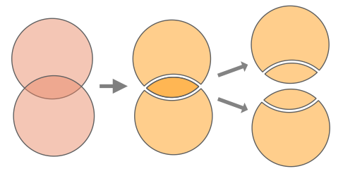
Fig. 24.172 Union operation with a single input layer with two overlapping features (left) - resulting in four features (middle) - features moved for clarity (right)
An overlay layer can also be used, in which case features from each layer are split at their overlap with features from the other one, creating a layer containing all the portions from both input and overlay layers. Features on the same layer will not split each other. The attribute table of the union layer is filled with attribute values from the respective original layer for non-overlapping features, and attribute values from both layers for overlapping features.
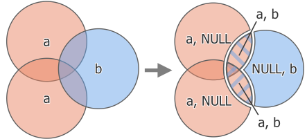
Fig. 24.173 Union operation between a two-feature input layer ‘a’ and a single feature overlay layer ‘b’ (left) - resulting five-feature layer with attributes from both layers (right)
Nota
With an overlay layer, features on the same layer will not split each other. If you want to split overlaps on the same layer as well as other layers, first run the algorithm with multiple layers then run the algorithm again with only the previous output.
Default menu:
Aviso
This algorithm drops existing primary keys or FID values and regenerate them in output layers.
Ver também
Parâmetros
Parâmetros básicos
Etiqueta |
Nome |
Tipo |
Descrição |
|---|---|---|---|
Camada de entrada |
|
[vector: geometry] |
Input vector layer to split at any intersections. |
Overlay layer Opcional |
|
[vector: geometry] |
Layer that will be combined to the first one. Ideally the geometry type should be the same as input layer. |
União |
|
[o mesmo que entrada] Padrão: |
Specify the layer to contain the (split and duplicated) features from the input layer and the overlay layer. One of:
A codificação do arquivo também pode ser alterada aqui. |
Parâmetros avançados
Etiqueta |
Nome |
Tipo |
Descrição |
|---|---|---|---|
Overlay fields prefix Opcional |
|
[string] |
Add a prefix to identify fields of the overlay layer. Duplicate field names will be appended a count suffix to avoid collision. |
Grid size Opcional |
|
[numeric: double] Padrão: Não definido |
If provided, the input geometries are snapped to a grid of the given size, and the result vertices are computed on that same grid. |
Saídas
Etiqueta |
Nome |
Tipo |
Descrição |
|---|---|---|---|
União |
|
[o mesmo que entrada] |
Layer containing all the overlapping and non-overlapping parts from the processed layer(s). |
Código Python
Algorithm ID: native:union
import processing
processing.run("algorithm_id", {parameter_dictionary})
O id do algoritmo é exibido quando você passa o mouse sobre o algoritmo na Caixa de ferramentas de processamento. O dicionário de parâmetros fornece os nomes e valores dos parâmetros. Veja Usando os algoritmos do processamento a partir do Terminal Python. para detalhes sobre como executar algoritmos de processamento a partir do console Python.
24.1.27.11. Union (multiple)
Checks overlaps between features within the input layer and creates separate features for overlapping and non-overlapping parts. The area of overlap will create as many identical overlapping features as there are features that participate in that overlap.
Fig. 24.174 Union operation with a single input layer with two overlapping features (left) - resulting in four features (middle) - features moved for clarity (right)
Multiple overlay layers can also be used, in which case features from each layer are split at their overlap with features from all other layers, creating a layer containing all the portions from both input and overlay layers. Features on the same layer will not split each other. The attribute table of the Union layer is filled with attribute values from the respective original layer for non-overlapping features, and attribute values from overlay layers for overlapping features.
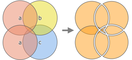
Fig. 24.175 Union operation between a two-feature input layer ‘a’ and single feature overlay layers ‘b’ and ‘c’ (left) - resulting eleven-feature layer with attributes from all layers (right)
Nota
With an overlay layer, features on the same layer will not split each other. If you want to split overlaps on the same layer as well as other layers, first run the algorithm with multiple layers then run the algorithm again with only the previous output.
Aviso
This algorithm drops existing primary keys or FID values and regenerate them in output layers.
Ver também
Parâmetros
Parâmetros básicos
Etiqueta |
Nome |
Tipo |
Descrição |
|---|---|---|---|
Camada de entrada |
|
[vector: geometry] |
Input vector layer to split at any intersections. |
Overlay layers Opcional |
|
[vector: geometry] [list] |
Layers that will be combined to the first one. Ideally the geometry type should be the same as input layer. |
União |
|
[o mesmo que entrada] Padrão: |
Specify the layer to contain the (split and duplicated) features from the input layer and the overlay layers. One of:
A codificação do arquivo também pode ser alterada aqui. |
Parâmetros avançados
Etiqueta |
Nome |
Tipo |
Descrição |
|---|---|---|---|
Overlay fields prefix Opcional |
|
[string] |
Add a prefix to identify fields of the overlay layers. Duplicate field names will be appended a count suffix to avoid collision. |
Saídas
Etiqueta |
Nome |
Tipo |
Descrição |
|---|---|---|---|
União |
|
[o mesmo que entrada] |
Layer containing all the overlapping and non-overlapping parts from the processed layer(s), with all layers’ attributes. |
Código Python
Algorithm ID: native:multiunion
import processing
processing.run("algorithm_id", {parameter_dictionary})
O id do algoritmo é exibido quando você passa o mouse sobre o algoritmo na Caixa de ferramentas de processamento. O dicionário de parâmetros fornece os nomes e valores dos parâmetros. Veja Usando os algoritmos do processamento a partir do Terminal Python. para detalhes sobre como executar algoritmos de processamento a partir do console Python.