` `
Client Catalogo MetaSearch
Introduzione
MetaSearch è un plugin di QGIS per interfacciarsi con i servizi di catalogazione metadati, supporto standard del Catalogue Service for the Web (CSW) dell’OGC.
MetaSearch offre un approccio semplice ed intuitivo con un’interfaccia user-friendly per effettuare ricerche in cataloghi di metadati all’interno di QGIS.
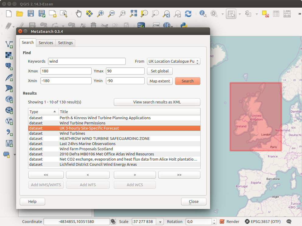
Search and results of Services in Metasearch
Installazione
MetaSearch è incluso per impostazione predefinita con QGIS 2.0 e versioni successive. Tutte le dipendenze sono incluse in MetaSearch.
Install MetaSearch from the QGIS plugin manager, or manually from http://plugins.qgis.org/plugins/MetaSearch.
Lavorare con i cataloghi dei metadati in QGIS
CSW (Catalog Service for the Web)
CSW (Catalog Service for the Web) is an OGC (Open Geospatial Consortium) specification, that defines common interfaces to discover, browse and query metadata about data, services, and other potential resources.
Avvio
To start MetaSearch, click  icon or select Web ‣
MetaSearch ‣ MetaSearch via the QGIS main menu. The MetaSearch dialog will
appear. The main GUI consists of three tabs: Services,
Search and Settings.
icon or select Web ‣
MetaSearch ‣ MetaSearch via the QGIS main menu. The MetaSearch dialog will
appear. The main GUI consists of three tabs: Services,
Search and Settings.
Managing Catalog Services
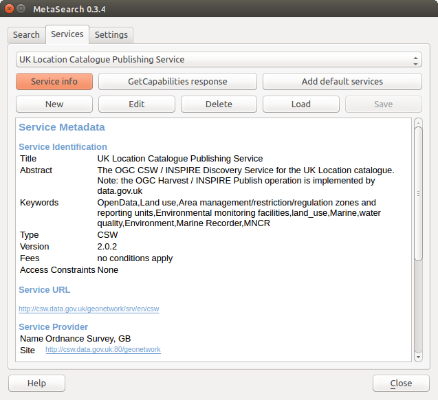
Managing Catalog Services
The Services tab allows the user to manage all available catalog services. MetaSearch provides a default list of Catalog Services, which can be added by pressing [Add default services] button.
Per l’elenco di tutte le voci del Servizio catalogo, fai click sulla casella di selezione a discesa.
To add a Catalog Service entry, click the [New] button, and enter a Name for the service, as well as the URL (endpoint). Note that only the base URL is required (not a full GetCapabilities URL). Clicking [OK] will add the service to the list of entries.
To edit an existing Catalog Service entry, select the entry you would like to edit and click the [Edit] button, and modify the Name or URL values, then click [OK].
To delete a Catalog Service entry, select the entry you would like to delete and click the [Delete] button. You will be asked to confirm deleting the entry.
MetaSearch permette di caricare e salvare le connessioni usando un file XML. Questo è utile se devi condividere le impostazioni tra più applicazioni. Segue un esempio di file in formato XML.
<?xml version="1.0" encoding="UTF-8"?>
<qgsCSWConnections version="1.0">
    <csw name="Data.gov CSW" url="https://catalog.data.gov/csw-all"/>
    <csw name="Geonorge - National CSW service for Norway" url="http://www.geonorge.no/geonetwork/srv/eng/csw"/>
    <csw name="Geoportale Nazionale - Servizio di ricerca Italiano" url="http://www.pcn.minambiente.it/geoportal/csw"/>
    <csw name="LINZ Data Service" url="http://data.linz.govt.nz/feeds/csw"/>
    <csw name="Nationaal Georegister (Nederland)" url="http://www.nationaalgeoregister.nl/geonetwork/srv/eng/csw"/>
    <csw name="RNDT - Repertorio Nazionale dei Dati Territoriali - Servizio di ricerca" url="http://www.rndt.gov.it/RNDT/CSW"/>
    <csw name="UK Location Catalogue Publishing Service" url="http://csw.data.gov.uk/geonetwork/srv/en/csw"/>
    <csw name="UNEP/GRID-Geneva Metadata Catalog" url="http://metadata.grid.unep.ch:8080/geonetwork/srv/eng/csw"/>
</qgsCSWConnections>
To load a list of entries, click the [Load] button. A new window will appear; click the [Browse] button and navigate to the XML file of entries you wish to load and click [Open]. The list of entries will be displayed. Select the entries you wish to add from the list and click [Load].
Click the [Service info] button to displays information about the selected Catalog Service such as service identification, service provider and contact information. If you would like to view the raw XML response, click the [GetCapabilities response] button. A separate window will open displaying Capabilities XML.
Searching Catalog Services
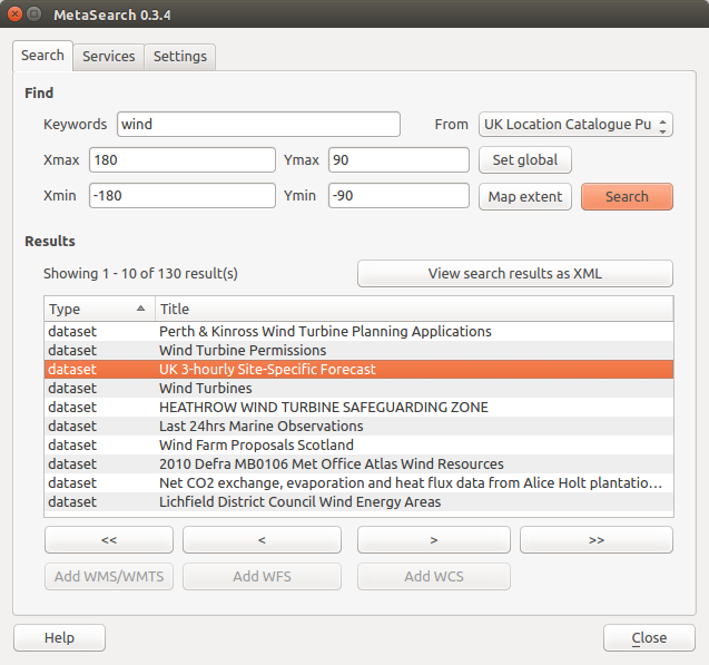
Searching catalog services
La scheda Cerca permette all’utente di interrogare i servizi di catalogazione per dati e servizi, impostare i parametri di ricerca e visualizzare i risultati.
Sono disponibili i seguenti parametri di ricerca:
Parole chiave: ricerca a testo libero sulle parole chiave;
Da: il servizio di catalogazione su cui effettuare le interrogazioni;
- Bounding box: the spatial area of interest to filter on defined by Xmax, Xmin, Ymax, and Ymin. Click [Set global] to do a global search, click [Map extent] to do a search on the visible area only or manually enter custom values as desired.
Clicking the [Search] button will search the selected Metadata Catalog. Search results are displayed in a list and are sortable by clicking on the column title. You can navigate through search results with the directional buttons below the search results. Clicking the [View search results as XML] button opens a window with the service response in raw XML format.
Clicking a result will provides the following options:
se il metadato ha una estensione geografica associata, ne verranno mostrati i limiti nella mappa;
doppio click su un record ne mostra i metadati con ogni collegamento di accesso associato. Cliccando su un link questo verrà aperto all’interno del browser
- if the record is an OGC web service (WMS/WMTS, WFS, WCS), the appropriate [Add to WMS/WMTS|WFS|WCS] buttons will be enabled for the user to add to QGIS. When clicking this button, MetaSearch will verify if this is a valid OWS. The OWS will then be added to the appropriate QGIS connection list, and the appropriate WMS/WMTS|WFS|WCS connection dialog will then appear.
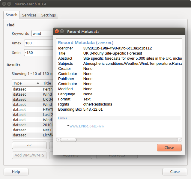
Visualizzazione Metadati del record
Impostazioni
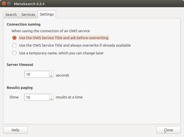
Metasearch setting
Puoi ottimizzare MetaSearch con le seguenti impostazioni: Impostazioni:
- Connection naming: when adding an OWS connection (WMS/WMTS|WFS|WCS), the connection is stored with the various QGIS layer provider. Use this setting to set whether to use the name provided from MetaSearch, whether to overwrite or to use a temporary name;
Impaginazione dei risultati: il numero di risultati da visualizzare per pagina durante la ricerca nei cataloghi di metadati. Il valore predefinito è 10 risultati per pagina.
Timeout del server: il numero di secondi dopo il quale bloccare il tentativo di connessione al server per la ricerca nei cataloghi di metadati. Il valore predefinito è 10 secondi;