` `
QGIS GUI
When QGIS starts, you are presented with the GUI as shown in the figure (the numbers 1 through 5 in yellow circles are discussed below).
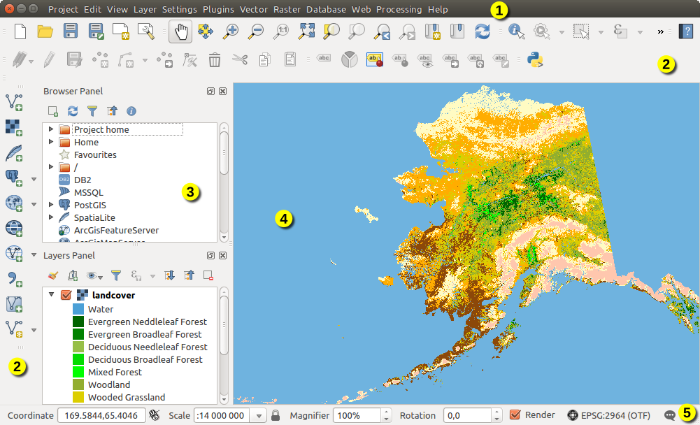
QGIS GUI con i dati di esempio Alaska
Nota
L’aspetto delle finestre (barra del titolo, ecc.) potrà apparire diverso a seconda del sistema operativo e dell’ambiente desktop.
La QGIS GUI è divisa in 5 aree:
Barra dei Menu
Barre degli strumenti
Pannelli
Mappa
Barra di Stato
These five components of the QGIS interface are described in more detail in the following sections. Two more sections present keyboard shortcuts and context help.
Barra dei Menu
The menu bar provides access to various QGIS features using a standard hierarchical menu. The top-level menus and a summary of some of the menu options are listed below, together with the associated icons as they appear on the toolbar, and keyboard shortcuts. The shortcuts presented in this section are the defaults; however, keyboard shortcuts can also be configured manually using the Configure shortcuts dialog, opened from Settings ‣ Configure Shortcuts....
Although most menu options have a corresponding tool and vice-versa, the menus are not organized exactly like the toolbars. The toolbar containing the tool is listed after each menu option as a checkbox entry. Some menu options only appear if the corresponding plugin is loaded. For more information about tools and toolbars, see section Barre degli strumenti.
Nota
QGIS is a cross-platform application meaning that though it provides you with the same tools, they may be placed in different menus according to the operating system specification. The lists below show the most common location and precise when there is a variation.
Progetto
Voce di Menu |
Scorciatoia |
Riferimento |
Barra degli Strumenti |
|---|---|---|---|
|
Ctrl+N | see Projects | Progetto |
 Open Open |
Ctrl+O | see Projects | Progetto |
Nuovo da modello ‣ |
see Projects | ||
Apri Recenti ‣ |
see Projects | ||
|
Ctrl+S | see Projects | Progetto |
|
Ctrl+Shift+S | see Projects | Progetto |
 Save as Image... Save as Image... |
see Output | ||
| DXF Export... | see Output | ||
| DWG/DXF Import... | |||
 Project Properties... Project Properties... |
Ctrl+Shift+P | see Projects | |
 New Print Composer New Print Composer |
Ctrl+P | see Print Composer | Progetto |
 Composer manager... Composer manager... |
see Print Composer | Progetto |
|
| Print Composers ‣ | see Print Composer | ||
|
Ctrl+Q |


 Esci da QGIS
In  macOS, il comando Exit QGIS corrisponde a QGIS ‣ Esci da QGIS (Cmd+Q).
Modifica
Voce di Menu |
Scorciatoia |
Riferimento |
Barra degli Strumenti |
|---|---|---|---|
|
Ctrl+Z | see Digitalizzazione avanzata | Digitalizzazione avanzata |
|
Ctrl+Shift+Z | see Digitalizzazione avanzata | Digitalizzazione avanzata |
|
Ctrl+X | see Modifica di un layer esistente | Digitalizzazione |
|
Ctrl+C | see Modifica di un layer esistente | Digitalizzazione |
|
Ctrl+V | see Modifica di un layer esistente | Digitalizzazione |
| Paste features as ‣ | see Lavorare con la tabella degli attributi | ||
 Add Feature Add Feature |
Ctrl+. | see Modifica di un layer esistente | Digitalizzazione |
|
see Modifica di un layer esistente | Digitalizzazione |
|
|
see Modifica di un layer esistente | Digitalizzazione |
|
|
see Modifica di un layer esistente | Digitalizzazione |
|
|
see Modifica di un layer esistente | Digitalizzazione |
|
|
see Modifica dei valori nella tabella degli attributi | Digitalizzazione |
|
|
see Digitalizzazione avanzata | Digitalizzazione avanzata |
|
|
see Digitalizzazione avanzata | Digitalizzazione avanzata |
|
|
see Digitalizzazione avanzata | Digitalizzazione avanzata |
|
|
see Digitalizzazione avanzata | Digitalizzazione avanzata |
|
|
see Digitalizzazione avanzata | Digitalizzazione avanzata |
|
|
see Digitalizzazione avanzata | Digitalizzazione avanzata |
|
|
see Digitalizzazione avanzata | Digitalizzazione avanzata |
|
|
see Digitalizzazione avanzata | Digitalizzazione avanzata |
|
|
see Digitalizzazione avanzata | Digitalizzazione avanzata |
|
|
see Digitalizzazione avanzata | Digitalizzazione avanzata |
|
|
see Digitalizzazione avanzata | Digitalizzazione avanzata |
|
|
see Digitalizzazione avanzata | Digitalizzazione avanzata |
|
 Merge Attr. of Selected Features Merge Attr. of Selected Features |
see Digitalizzazione avanzata | Digitalizzazione avanzata |
|
 Node Tool Node Tool |
see Modifica di un layer esistente | Digitalizzazione |
|
|
see Digitalizzazione avanzata | Digitalizzazione avanzata |
|
|
see Digitalizzazione avanzata | Digitalizzazione avanzata |


After activating  Toggle editing mode for a layer,
you will enable the Add Feature icon in the Edit menu
depending on the layer type (point, line or polygon).
Toggle editing mode for a layer,
you will enable the Add Feature icon in the Edit menu
depending on the layer type (point, line or polygon).
Edit (extra)
Voce di Menu |
Scorciatoia |
Riferimento |
Barra degli Strumenti |
|---|---|---|---|
| Add Feature |
see Modifica di un layer esistente | Digitalizzazione |
|
 Add Feature Add Feature |
see Modifica di un layer esistente | Digitalizzazione |
|
 Add Feature Add Feature |
see Modifica di un layer esistente | Digitalizzazione |
Mappa
Voce di Menu |
Scorciatoia |
Riferimento |
Barra degli Strumenti |
|---|---|---|---|
|
see Zoom e Pan | Navigazione mappa |
|
|
Navigazione mappa |
||
|
Ctrl+Alt++ | see Zoom e Pan | Navigazione mappa |
|
Ctrl+Alt+- | see Zoom e Pan | Navigazione mappa |
Seleziona ‣ |
see Selezionare geometrie | Attributi |
|
|
Ctrl+Shift+I | see Identify Features | Attributi |
Misura ‣ |
see Misurazioni | Attributi |
|
|
see Pannello Statistiche | Attributi |
|
|
Ctrl+Shift+F | Navigazione mappa |
|
|
Navigazione mappa |
||
|
Ctrl+J | Navigazione mappa |
|
|
Navigazione mappa |
||
|
Navigazione mappa |
||
 Zoom To Native Resolution Zoom To Native Resolution |
Navigazione mappa |
||
Proprietà ‣ |
see Decorazioni | ||
Modalità anteprima ‣ |
|||
 Map Tips Map Tips |
see Scheda Suggerimenti | Attributi |
|
|
Ctrl+B | see Segnalibri geospaziali | Attributi |
|
Ctrl+Shift+B | see Segnalibri geospaziali | Attributi |
|
F5 | Navigazione mappa |
|
Pannelli ‣ |
see Pannelli e Barre degli strumenti | ||
Barre degli strumenti ‣ |
see Pannelli e Barre degli strumenti | ||
Attiva la modalità a schermo intero |
F11 |


Under  Linux KDE, Panels ‣, Toolbars ‣
and Toggle Full Screen Mode are rather placed in Settings
menu.
Preview mode ‣ is not available under macOS.
Linux KDE, Panels ‣, Toolbars ‣
and Toggle Full Screen Mode are rather placed in Settings
menu.
Preview mode ‣ is not available under macOS.
Layer
Voce di Menu |
Scorciatoia |
Riferimento |
Barra degli Strumenti |
|---|---|---|---|
Crea Layer ‣ |
see Creating new vector layers | Manage Layers | |
Aggiungi Layer ‣ |
see Esplorare i formati dati e i campi | Manage Layers | |
Includi Layers e Gruppi... |
see Progetti nidificati | ||
Aggiungi da un file di definizione del layer... |
|||
 Copy style Copy style |
see Salvare e condividere le proprietà di un layer | ||
 Paste style Paste style |
see Salvare e condividere le proprietà di un layer | ||
|
F6 | see Lavorare con la tabella degli attributi | Attributi |
|
see Modifica di un layer esistente | Digitalizzazione |
|
|
see Modifica di un layer esistente | Digitalizzazione |
|
|
see Modifica di un layer esistente | Digitalizzazione |
|
| Save As... | see Creating new layers from an existing layer | ||
| Save As Layer Definition File... | |||
|
Ctrl+D | ||
|
|||
Definisci la scala di visibilità del/dei Layer(s) |
|||
Imposta SR del/dei Layer(s) |
Ctrl+Shift+C | ||
Imposta SR del Progetto dal Layer |
|||
Proprietà... |
see Proprietà dei vettori | ||
Filtra... |
Ctrl+F | see Costruttore di interrogazioni | |
|
see Proprietà etichette | ||
 Add to Overview Add to Overview |
Ctrl+Shift+O | Manage Layers | |
 Add All To Overview Add All To Overview |
|||
 Remove All From Overview Remove All From Overview |
|||
|
Ctrl+Shift+U | Manage Layers | |
|
Ctrl+Shift+H | Manage Layers | |
 Show selected Layers Show selected Layers |
|||
 Hide selected Layers Hide selected Layers |


Impostazioni
Voce di Menu |
Scorciatoia |
Riferimento |
Barra degli Strumenti |
|---|---|---|---|
 Custom CRS... Custom CRS... |
see Sistemi di riferimento personalizzati | ||
 Style Manager... Style Manager... |
see Gestore di stile | ||
 Configure shortcuts... Configure shortcuts... |
see Tasti di scelta rapida | ||
| Customization... |
see Personalizzazione | ||
|
see Opzioni dell’interfaccia grafica (GUI) | ||
Opzioni di aggancio... |
see Impostare la Tolleranza dello Snapping e il raggio di ricerca degli elementi |
Under Linux KDE, you’ll find more tools in Settings
menu such as Project Properties, Panels ‣,
Toolbars ‣ and Toggle Full Screen Mode.
Plugins
Voce di Menu |
Scorciatoia |
Riferimento |
Barra degli Strumenti |
|---|---|---|---|
|
see La finestra di dialogo Plugins | ||
| Python Console | Ctrl+Alt+P |

Quando si avvia QGIS per la prima volta non tutti i plugin di base verranno caricati.
Vettore
Voce di Menu |
Scorciatoia |
Riferimento |
Barra degli Strumenti |
|---|---|---|---|
| OpenStreetMap ‣ | see Importare vettori OpenStreetMap | ||
 Analysis Tools ‣ Analysis Tools ‣ |
see Menu Vettore | ||
 Research Tools ‣ Research Tools ‣ |
see Menu Vettore | ||
 Geoprocessing Tools ‣ Geoprocessing Tools ‣ |
see Menu Vettore | ||
 Geometry Tools ‣ Geometry Tools ‣ |
see Menu Vettore | ||
 Data Management Tools ‣ Data Management Tools ‣ |
see Menu Vettore |
When starting QGIS for the first time not all core plugins are loaded. Many of the above-mentioned sub-menus require the core plugin Processing to be activated.
Raster
Voce di Menu |
Scorciatoia |
Riferimento |
Barra degli Strumenti |
|---|---|---|---|
| Raster calculator... | see Calcolatore raster | ||
Alinea Raster... |
see Allineamento Raster | ||
| Analysis ‣ |
see Plugin GDALTools | ||
| Projection ‣ |
see Plugin GDALTools | ||
| Conversion ‣ |
see Plugin GDALTools | ||
| Miscellaneous ‣ |
see Plugin GDALTools | ||
| Extraction ‣ |
see Plugin GDALTools |
When starting QGIS for the first time not all core plugins are loaded. Many of the above-mentioned sub-menus require the core plugin Processing to be activated.
Database
Voce di Menu |
Scorciatoia |
Riferimento |
Barra degli Strumenti |
|---|---|---|---|
| Database ‣ | see Plugin DB Manager | Database |
Quando si avvia QGIS per la prima volta non tutti i plugin di base verranno caricati.
Web
Voce di Menu |
Scorciatoia |
Riferimento |
Barra degli Strumenti |
|---|---|---|---|
| Metasearch | see Client Catalogo MetaSearch | Web |
Quando si avvia QGIS per la prima volta non tutti i plugin di base verranno caricati.
Processing
Voce di Menu |
Scorciatoia |
Riferimento |
Barra degli Strumenti |
|---|---|---|---|
 Toolbox Toolbox |
see The toolbox | ||
|
see Modellatore grafico | ||
 History and log... History and log... |
see Il gestore della cronologia di Processing | ||
 Options... Options... |
see Configuring the processing framework | ||
 Results viewer... Results viewer... |
see Configurazione di applicazioni esterne | ||
 Commander Commander |
Ctrl+Alt+M | see La riga di comando |

Quando si avvia QGIS per la prima volta non tutti i plugin di base verranno caricati.
Guida
Voce di Menu |
Scorciatoia |
Riferimento |
Barra degli Strumenti |
|---|---|---|---|
|
F1 | Guida |
|
 What’s This? What’s This? |
Shift+F1 | Guida |
|
Documentazione sulle API |
|||
Segnala un problema |
|||
Serve supporto commerciale? |
|||
|
Ctrl+H | ||
 Check QGIS Version Check QGIS Version |
|||
 About About |
|||
 QGIS Sponsors QGIS Sponsors |


QGIS
Questo menu è disponibile solo in macOS e contiene alcuni comandi relativi a tale sistema operativo.
Voce di Menu |
Scorciatoia |
Riferimento |
|---|---|---|
Preferenze |
||
Aiuto su QGIS |
||
Nascondi QGIS |
||
Mostra tutto |
||
Nascondi gli altri |
||
Esci da QGIS |
Cmd+Q |
Preferenze e About QGIS sono comandi equivalenti a Impostazioni ‣ Opzioni e Aiuto ‣ About. Esci da QGIS corresponde a Progetto ‣ Esci da QGIS negli altri sistemi.
Pannelli e Barre degli strumenti
From the View menu (or Settings), you can
switch on and off QGIS widgets (Panels ‣) or toolbars
(Toolbars ‣). You can (de)activate any of them by
right-clicking the menu bar or a toolbar and choose the item you want.
Each panel or toolbar can be moved and placed wherever you feel comfortable
within QGIS interface.
The list can also be extended with the activation of Core or external
plugins.
Barre degli strumenti
The toolbar provides access to most of the same functions as the menus, plus additional tools for interacting with the map. Each toolbar item has pop-up help available. Hold your mouse over the item and a short description of the tool’s purpose will be displayed.
Puoi spostare a piacimento ogni barra in funzione delle tue esigenze. Inoltre puoi disattivare ogni barra cliccando con il tasto destro sulla barra degli strumenti disattivando la voce relativa nel menu.
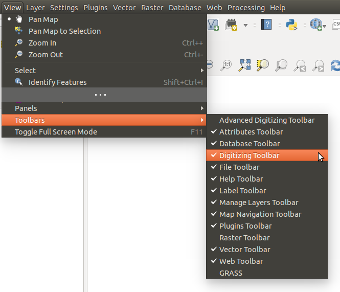
Il menu Barra degli strumenti
Suggerimento
Ripristinare le barre degli strumenti
Se hai disattivato accidentalmente una barra strumenti, puoi ripristinarla dalla voce di menu Visualizza ‣ Barre degli strumenti ‣ (o Impostazioni ‣ Barre degli strumenti ‣). Se una barra degli strumenti per qualsiasi ragione scompare dall’interfaccia di QGIS puoi effettuare il ripristino come descritto in ripristinare la GUI iniziale.
Pannelli
Besides toolbars, QGIS provides by default many panels to work with. Panels are special widgets that you can interact with (selecting options, checking boxes, filling values...) in order to perform a more complex task.
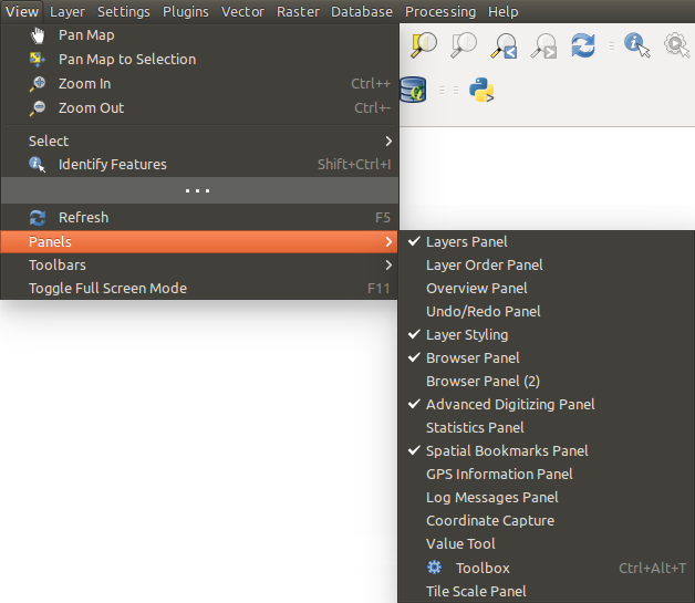
Il menu Pannelli
Di seguito la lista dei pannelli di default previsti in QGIS:
- the Browser Panel
Mappa
Chiamata anche Rappresentazione della Mappa, questa è il “fine aziendale” di QGIS – le mappe vengono visualizzate in questa area. La mappa visualizzata in questa finestra dipenderà dai layer vettoriali e raster che hai scelto di caricare.
When you add a layer (see e.g. Accedere ai dati), QGIS automatically looks for its Coordinate Reference System (CRS) and zooms to its extent if you work in a blank QGIS project. The layer’s CRS is then applied to the project. If there are already layers in the project, and in the case the new layer has the same CRS as the project, its features falling in the current map canvas extent will be visualized. If the new layer is in a different CRS from the project’s, you must Enable on-the-fly CRS transformation from the Project ‣ Project Properties ‣ CRS (see Definire la trasformazione del SR al volo (OTF)). The added layer should now be visible if data are available in the current view extent.
The map view can be panned, shifting the focus of the map display to another region, and it can be zoomed in and out. Various other operations can be performed on the map as described in the Barre degli strumenti description. The map view and the legend are tightly bound to each other — the maps in view reflect changes you make in the legend area.
Suggerimento
ZOOM IN E ZOOM OUT CON LA ROTELLA DEL MOUSE
Per le operazioni di zoom puoi anche utilizzare la rotella del mouse. Posizionando il puntatore del mouse nell’area di visualizzazione delle mappe aumenterai lo zoom girando la rotella verso lo schermo, lo ridurrai girandola nel verso contrario. La posizione del puntatore costituisce il centro per l’ingrandimento. Puoi regolare il comportamento della funzione di zoom con la rotella del mouse nella scheda Strumenti mappa del menu Impostazioni ‣ Opzioni .
Suggerimento
MUOVERE LA MAPPA CON I TASTI FRECCIA E LA BARRA SPAZIATRICE
You can use the arrow keys to pan the map. Place the mouse cursor inside the map area and click on the right arrow key to pan east, left arrow key to pan west, up arrow key to pan north and down arrow key to pan south. You can also pan the map using the space bar or the click on mouse wheel: just move the mouse while holding down space bar or click on mouse wheel.
Barra di Stato
The status bar provides you with general information about the map view, and actions processed or available and offers you tools to manage the map view.
On the left side of the status bar, you can get a summary of actions you’ve done (such as selecting features in a layer, removing layer) or a long description of the tool you are hovering over (not available for all tools). On startup, the bar status also informs you about availability of new or upgradeable plugins (if checked in Plugin Manager settings).
In case of lengthy operations, such as gathering of statistics in raster layers or rendering several layers in map view, a progress bar is displayed in the status bar to show the current progress of the action.
The ![]() Coordinate option shows the current position of the mouse,
following it while moving across the map view. You can set the unit (and precision)
to use in the project properties, General tab.
Click on the small button at the left of the textbox to toggle between
the Coordinate option and the
Coordinate option shows the current position of the mouse,
following it while moving across the map view. You can set the unit (and precision)
to use in the project properties, General tab.
Click on the small button at the left of the textbox to toggle between
the Coordinate option and the  Extents option that displays
in map units, the coordinates of the current lower leftmost and upper rightmost
points of the map view, as you pan and zoom in and out.
Extents option that displays
in map units, the coordinates of the current lower leftmost and upper rightmost
points of the map view, as you pan and zoom in and out.
Next to the coordinate display you will find the Scale display. It shows the scale of the map view. If you zoom in or out, QGIS shows you the current scale. There is a scale selector, which allows you to choose among predefined and custom scales to assign to the map view.
On the right side of the scale display you can define a current magnification level for your map view. This allows to zoom in to a map without altering the map scale, making it easier to accurately tweak the positions of labels and symbols. The magnification level is expressed as a percentage. If the Magnifier has a level of 100%, then the current map is not magnified. Additionally, a default magnification value can be defined within Settings ‣ Options ‣ Rendering ‣ Rendering behaviour, which is very useful for high resolution screen to avoid too small symbols.
A destra della scala puoi definire la rotazione corrente in gradi in senso orario della mappa.
On the right side of the status bar, there is a small checkbox which can be used to temporarily prevent layers being rendered to the map view (see section Visualizzazione).
To the right of the render functions, you find the  Current CRS: icon with the EPSG code of the current
project CRS. Clicking on this lets you Enable ‘on the fly’ CRS
transformation properties for the current project and apply another CRS to the
map view.
Current CRS: icon with the EPSG code of the current
project CRS. Clicking on this lets you Enable ‘on the fly’ CRS
transformation properties for the current project and apply another CRS to the
map view.
Finally, the  Messages button opens the Log
Messages Panel which informs you on underlying process (QGIS startup, plugins
loading, processing tools...)
Messages button opens the Log
Messages Panel which informs you on underlying process (QGIS startup, plugins
loading, processing tools...)
Suggerimento
Calcolare la scala corretta della mappa
When you start QGIS, the default CRS is WGS 84 (epsg 4326) and
units are degrees. This means that QGIS will interpret any
coordinate in your layer as specified in degrees. To get correct scale values,
you can either manually change this setting, e.g. to meters, in the General
tab under Project ‣ Project Properties, or you can use
the Current CRS: icon seen above. In the latter case,
the units are set to what the project projection specifies (e.g., +units=us-ft).
Da notare che la scelta del sistema SR di partenza può essere fatta in Impostazioni ‣ Opzioni ‣ SR.