` `
Expressões
Based on layer data and prebuilt or user defined functions, Expressions offer a powerful way to manipulate attribute value, geometry and variables in order to dynamically change the geometry style, the content or position of the label, the value for diagram, the height of a composer item, select some features, create virtual field ...
O Construtor de expressão string
A plataforma principal para construir expressões, o Expression string builder está disponível em muitas partes no QGIS e, pode ser acessado quando:
clicando no botão expressão;
ref:selecionando feições<sec_selection> com a ferramenta
 Selecionar por Expressão...;
editando atributos com a ferramenta
 Calculadora de Campo;
- manipulating symbology, label or composer item parameters with the
 Data defined override tool (see Data defined override setup);
 Construindo uma camada de símbolo de geradora de geometria ;
Realizando algum geoprocessamento.
A plataforma de Construção de Expressão oferece acesso a:
Aba de Expressão, a qual ajuda a escrever e verificar a expressão a ser usada, graças a uma lista predefinida de funções;
Aba de Editor de Função a qual ajuda a expandir a lista de funções por meio de criações customizadas de novas funções.
Alguns casos de usos das Expressões:
A partir da Calculadora de Campo, calcula-se um campo de densidade populacional (“pop_density”) usando os campos existentes de população (“total_pop”) e de área (“area_km2”):
"total_pop" / "area_km2"
Atualiza-se o campo sobre nível de densidade (“density_level”) com categorias de acordo com os valores da densidade (“pop_density”):
CASE WHEN "pop_density" < 50 THEN 'Low population density'
     WHEN "pop_density" >= 50 and "pop_density" < 150 THEN 'Medium population density'
     WHEN "pop_density" >= 150 THEN 'High population density'
END
Aplica-se um estilo categorizado para todas as feições de acordo com condição do valor médio da casa ser maior ou maior do que 10000€ por metro quadrado:
"price_m2" > 10000
Usando a ferramenta “Selecionar por Expressão...”, seleciona-se todas as feições representativas de áreas de “Alta densidade populacional” e as quais possuem valor médio da casa maior do que 10000€ por metro 2:
"density_level" = 'High population density' and "price_m2" > 10000
Do mesmo modo, a expressão anterior poderia também ser usada para definir quais feições deveriam ser rotuladas ou mostradas no mapa.
Usar expressões permite a você um monte de possibilidades.
Dica
Use Parâmetros Nomeados para aperfeiçoar a leitura da expressão
Algumas funções exigem a configuração de inúmeros parâmetros. O mecanismo de Expressão suporta o uso de Parâmetros nomeados. Isto significa que ao invés de escrever a expressão criptografada clamp( 1, 2, 9), você pode usar clamp( min:=1, value:=2, max:=9). Isto permite que os argumentos sejam trocados, por exemplo, clamp( value:=2, max:=9, min:=1). Usar Parâmetros nomeados ajuda a esclarecer ao que os argumentos de uma função se referem, o que pode ser útil quando você estará tentando interpretar uma função no futuro.
Lista de funções
The Expression tab provides the main interface to write expressions using functions, layer’s fields and values. It contains widgets to:
- type expressions using functions and/or fields. At the bottom of the dialog, is displayed the result of the expression evaluated on the first feature of the layer.
- select the appropriate function among a list, organized in groups. A search box is available to filter the list and quickly find a particular function or field. Double-clicking on the item’s name adds it to the expression being written.
- display help for each function selected. When a field is selected, this widget shows a sample of its values. Double-clicking a value adds it to the expression.
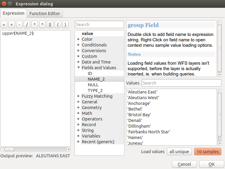
The Expression tab
Operadores
This group contains operators (e.g., +, -, *). Note that for most of the mathematical functions below, if one of the inputs is NULL then the result is NULL.
Função |
Descrição |
|---|---|
| a + b | Adição de dois valores (a mais b) |
| a - b | Subtração de dois valores (a menos b) |
| a * b | Multiplicação de dois valores (a multiplicado por b) |
| a / b | Divisão de dois valores (a dividido por b) |
| a % b | Remainder of division of a by b (eg, 7 % 2 = 1, or 2 fits into 7 three times with remainder 1) |
| a ^ b | Power of two values (for example, 2^2=4 or 2^3=8) |
| a < b | Compares two values and evaluates to 1 if the left value is less than the right value (a is smaller than b) |
| a <= b | Compares two values and evaluates to 1 if the left value isless than or equal to the right value |
| a <> b | Compares two values and evaluates to 1 if they are not equal |
| a = b | Compares two values and evaluates to 1 if they are equal |
| a != b | a and b are not equal |
| a > b | Compares two values and evaluates to 1 if the left value is greater than the right value (a is larger than b) |
| a >= b | Compares two values and evaluates to 1 if the left value is greater than or equal to the right value |
| a ~ b | a matches the regular expression b |
| || | Joins two values together into a string. If one of the values is NULL the result will be NULL |
| ‘\n’ | Inserts a new line in a string |
| LIKE | Returns 1 if the first parameter matches the supplied pattern |
| ILIKE | Returns 1 if the first parameter matches case-insensitive the supplied pattern (ILIKE can be used instead of LIKE to make the match case-insensitive) |
| a IS b | Tests whether two values are identical. Returns 1 if a is the same as b |
| a OR b | Returns 1 when condition a or condition b is true |
| a AND b | Returns 1 when conditions a and b are true |
| NOT | Negates a condition |
| column name “column name” | Value of the field column name, take care to not be confused with simple quote, see below |
| ‘string’ | a string value, take care to not be confused with double quote, see above |
| NULL | valor nulo |
| a IS NULL | a has no value |
| a IS NOT NULL | a has a value |
| a IN (value[,value]) | a is below the values listed |
| a NOT IN (value[,value]) | a is not below the values listed |
Nota
About fields concatenation
You can concatenate strings using either || or +. The latter also means sum up expression. So if you have an integer (field or numeric value) this can be error prone. In this case, you should use ||. If you concatenate two string values, you can use both.
Alguns exemplos:
Juntando um texto e um valor a partir de um nome de coluna:
'My feature''s id is: ' || "gid"
'My feature''s id is: ' + "gid" => triggers an error as gid is an integer
"country_name" + '(' + "country_code" + ')'
"country_name" || '(' || "country_code" || ')'
Test if the “description” attribute field starts with the ‘Hello’ string in the value (note the position of the % character):
"description" LIKE 'Hello%'
Conditionals
Este grupo contém funções para lidar com verificações condicionais em expressões.
Função |
Descrição |
|---|---|
| CASE WHEN ... THEN ... END | Evaluates an expression and returns a result if true. You can test multiple conditions |
| CASE WHEN ... THEN ... ELSE ... END | Evaluates an expression and returns a different result whether it’s true or false. You can test multiple conditions |
| coalesce | Returns the first non-NULL value from the expression list |
| if | Tests a condition and returns a different result depending on the conditional check |
| regexp_match | Returns true if any part of a string matches the supplied regular expression |
Alguns exemplos:
Enviar de volta um valor se a primeira condição é verdade, outra coisa manda outro valor:
CASE WHEN "software" LIKE '%QGIS%' THEN 'QGIS' ELSE 'Other' END
Funções Matemáticas
Este grupo contém funções matemáticas (por exemplo, raiz quadrada, sen e cos).
Função |
Descrição |
|---|---|
| abs | Returns the absolute value of a number |
| acos | Returns the inverse cosine of a value in radians |
| asin | Returns the inverse sine of a value in radians |
| atan | Returns the inverse tangent of a value in radians |
| atan2(y,x) | Returns the inverse tangent of y/x by using the signs of the two arguments to determine the quadrant of the result |
| azimuth(a,b) | Returns the north-based azimuth as the angle in radians measured clockwise from the vertical on point a to point b |
| ceil | Rounds a number upwards |
| clamp | Restricts an input value to a specified range |
| cos | Returns the cosine of a value in radians |
graus |
Converts from radians to degrees |
| exp | Returns exponential of a value |
| floor | Rounds a number downwards |
| ln | Returns the natural logarithm of the passed expression |
| log | Returns the value of the logarithm of the passed value and base |
| log10 | Returns the value of the base 10 logarithm of the passed expression |
| max | Returns the largest value in a set of values |
| min | Returns the smallest value in a set of values |
| pi | Returns the value of pi for calculations |
| radians | Converts from degrees to radians |
| rand | Returns the random integer within the range specified by the minimum and maximum argument (inclusive) |
| randf | Returns the random float within the range specified by the minimum and maximum argument (inclusive) |
| round | Rounds to number of decimal places |
| scale_exp | Transforms a given value from an input domain to an output range using an exponential curve |
| scale_linear | Transforms a given value from an input domain to an output range using linear interpolation |
| sin | Returns the sine of an angle |
| sqrt | Returns the square root of a value |
| tan | Returns the tangent of an angle |
Aggregates Functions
This group contains functions which aggregate values over layers and fields.
Função |
Descrição |
|---|---|
| aggregate | Returns an aggregate value calculated using features from another layer |
| concatenate | Returns the all aggregated strings from a field or expression joined by a delimiter |
| count | Returns the count of matching features |
| count_distinct | Returns the count of distinct values |
| count_missing | Returns the count of missing (null) values |
| iqr | Returns the calculated inter quartile range from a field or expression |
| majority | Returns the aggregate majority of values (most commonly occurring value) from a field or expression |
| max_length | Returns the maximum length of strings from a field or expression |
| maximum | Returns the aggregate maximum value from a field or expression |
| mean | Returns the aggregate mean value from a field or expression |
| median | Returns the aggregate median value from a field or expression |
| min_length | Returns the minimum length of strings from a field or expression |
| minimum | Returns the aggregate minimum value from a field or expression |
| minority | Returns the aggregate minority of values (least commonly occurring value) from a field or expression |
| q1 | Returns the calculated first quartile from a field or expression |
| q3 | Returns the calculated third quartile from a field or expression |
| range | Returns the aggregate range of values (maximum - minimum) from a field or expression |
| relation_aggregate | Returns an aggregate value calculated using all matching child features from a layer relation |
| stdev | Returns the aggregate standard deviation value from a field or expression |
soma |
Returns the aggregate summed value from a field or expression |
Examples:
Return the maximum of the “passengers” field from features in the layer grouped by “station_class” field:
maximum("passengers", group_by:="station_class")Calculate the total number of passengers for the stations inside the current atlas feature:
aggregate('rail_stations','sum',"passengers",
  intersects(@atlas_geometry, $geometry))
Return the mean of the “field_from_related_table” field for all matching child features using the ‘my_relation’ relation from the layer:
aggregate_relation('my_relation', 'mean', "field_from_related_table")
or:
aggregate_relation(relation:='my_relation', calculation := 'mean',
  expression := "field_from_related_table")
Funções Cor
Este grupo contém funções para manipulação de cores.
Função |
Descrição |
|---|---|
| color_cmyk | Returns a string representation of a color based on its cyan, magenta, yellow and black components |
| color_cmyka | Returns a string representation of a color based on its cyan, magenta, yellow, black and alpha (transparency) components |
| color_hsl | Returns a string representation of a color based on its hue, saturation, and lightness attributes |
| color_hsla | Returns a string representation of a color based on its hue, saturation, lightness and alpha (transparency) attributes |
| color_hsv | Returns a string representation of a color based on its hue, saturation, and value attributes |
| color_hsva | Returns a string representation of a color based on its hue, saturation, value and alpha (transparency) attributes |
| color_part | Returns a specific component from a color string, eg the red component or alpha component |
| color_rgb | Returns a string representation of a color based on its red, green, and blue components |
| color_rgba | Returns a string representation of a color based on its red, green, blue, and alpha (transparency) components |
| darker | Returns a darker (or lighter) color string |
| lighter | Returns a lighter (or darker) color string |
| project_color | Returns a color from the project’s color scheme |
| ramp_color | Returns a string representing a color from a color ramp |
| set_color_part | Sets a specific color component for a color string, eg the red component or alpha component |
Conversions Functions
Este grupo contém funções para converter um tipo de dado para outro (por exemplo, texto para inteiro, inteiro para texto).
Função |
Descrição |
|---|---|
| to_date | Converts a string into a date object |
| to_datetime | Converts a string into a datetime object |
| to_int | Converts a string to integer number |
| to_interval | Converts a string to an interval type (can be used to take days, hours, months, etc. of a date) |
| to_real | Converts a string to a real number |
| to_string | Converts number to string |
| to_time | Converts a string into a time object |
Custom Functions
This group contains functions created by the user. See Function Editor for more details.
Funções Data e hora
Este grupo contém funções para trabalhar datas e hora data.
Função |
Descrição |
|---|---|
| age | Returns as an interval the difference between two dates or datetimes |
| day | Extracts the day from a date or datetime, or the number of days from an interval |
| day_of_week | Returns a number corresponding to the day of the week for a specified date or datetime |
| hour | Extracts the hour from a datetime or time, or the number of hours from an interval |
| minute | Extracts the minute from a datetime or time, or the number of minutes from an interval |
| month | Extracts the month part from a date or datetime, or the number of months from an interval |
| now | Returns current date and time |
| second | Extracts the second from a datetime or time, or the number of seconds from an interval |
| week | Extracts the week number from a date or datetime, or the number of weeks from an interval |
| year | Extracts the year part from a date or datetime, or the number of years from an interval |
This group also shares several functions with the Conversions Functions ( to_date, to_time, to_datetime, to_interval) and Funções String (format_date) groups.
Alguns exemplos:
Get today’s month and year in the “month_number/year” format:
format_date(now(),'MM/yyyy')
-- Returns '03/2017'
Besides these functions, subtracting dates, datetimes or times using the - (minus) operator will return an interval.
Adding or subtracting an interval to dates, datetimes or times, using the + (plus) and - (minus) operators, will return a datetime.
Get the number of days until QGIS 3.0 release:
to_date('2017-09-29') - to_date(now())
-- Returns <interval: 203 days>
The same with time:
to_datetime('2017-09-29 12:00:00') - to_datetime(now())
-- Returns <interval: 202.49 days>
Get the datetime of 100 days from now:
now() + to_interval('100 days')
-- Returns <datetime: 2017-06-18 01:00:00>
Nota
Storing date and datetime and intervals on fields
The ability to store date, time and datetime values directly on fields may depend on the data source’s provider (e.g., shapefiles accept date format, but not datetime or time format). The following are some suggestions to overcame this limitation.
date, Datetime and time can be stored in text type fields after using the to_format() function.
Intervals can be stored in integer or decimal type fields after using one of the date extraction functions (e.g., day() to get the interval expressed in days)
Campo e Valores
Contains a list of fields from the layer.
Generally, you can use the various fields, values and functions to construct the calculation expression, or you can just type it into the box.
To display the values of a field, you just click on the appropriate field and choose between Load top 10 unique values and Load all unique values. On the right side, the Field Values list opens with the unique values. At the top of the list, a search box helps filtering the values. To add a value to the expression you are writing, double click its name in the list.
Sample values can also be accessed via right-click. Select the field name from the list, then right-click to access a context menu with options to load sample values from the selected field.
Fields name should be double-quoted in the expression. Values or string should be simple-quoted.
Fuzzy Matching Functions
This group contains functions for fuzzy comparisons between values.
Função |
Descrição |
|---|---|
| hamming_distance | Returns the number of characters at corresponding positions within the input strings where the characters are different |
| levensheim | Returns the minimum number of character edits (insertions, deletions or substitutions) required to change one string to another. Measure the similarity between two strings |
| longest_common_substring | Returns the longest common substring between two strings |
| soundex | Returns the Soundex representation of a string |
General Functions
This group contains general assorted functions.
Função |
Descrição |
|---|---|
| eval | Evaluates an expression which is passed in a string. Useful to expand dynamic parameters passed as context variables or fields |
| layer_property | Returns a property of a layer or a value of its metadata. It can be layer name, crs, geometry type, feature count... |
| var | Returns the value stored within a specified variable. See variable functions below |
Funções Geometria
Este grupo contém funções que operam na geometria dos objetos (por exemplo, comprimento, área).
Função |
Descrição |
|---|---|
| $area | Returns the area size of the current feature |
| $geometry | Returns the geometry of the current feature (can be used for processing with other functions) |
| $length | Returns the length of the current line feature |
| $perimeter | Returns the perimeter of the current polygon feature |
| $x | Returns the x coordinate of the current feature |
| $x_at(n) | Returns the x coordinate of the nth node of the current feature’s geometry |
| $y | Returns the y coordinate of the current feature |
| $y_at(n) | Returns the y coordinate of the nth node of the current feature’s geometry |
| angle_at_vertex | Returns the bisector angle (average angle) to the geometry for a specified vertex on a linestring geometry. Angles are in degrees clockwise from north |
| area | Returns the area of a geometry polygon feature. Calculations are in the Spatial Reference System of this geometry |
| azimuth | Returns the north-based azimuth as the angle in radians measured clockwise from the vertical on point_a to point_b |
| boundary | Returns the closure of the combinatorial boundary of the geometry (ie the topological boundary of the geometry). |
| bounds | Returns a geometry which represents the bounding box of an input geometry. Calculations are in the Spatial Reference System of this geometry |
| bounds_height | Returns the height of the bounding box of a geometry. Calculations are in the Spatial Reference System of this geometry |
| bounds_width | Returns the width of the bounding box of a geometry. Calculations are in the Spatial Reference System of this geometry |
| buffer | Returns a geometry that represents all points whose distance from this geometry is less than or equal to distance. Calculations are in the Spatial Reference System of this geometry |
| centroid | Returns the geometric center of a geometry |
| closest_point | Returns the point on a geometry that is closest to a second geometry |
| combine | Returns the combination of two geometries |
| contains(a,b) | Returns 1 (true) if and only if no points of b lie in the exterior of a, and at least one point of the interior of b lies in the interior of a |
| convex_hull | Returns the convex hull of a geometry (this represents the minimum convex geometry that encloses all geometries within the set) |
| crosses | Returns 1 (true) if the supplied geometries have some, but not all, interior points in common |
| difference(a,b) | Returns a geometry that represents that part of geometry a that does not intersect with geometry b |
| disjoint | Returns 1 (true) if the geometries do not share any space together |
| distance | Returns the minimum distance (based on Spatial Reference System) between two geometries in projected units |
| distance_to_vertex | Returns the distance along the geometry to a specified vertex |
| end_point | Returns the last node from a geometry |
| exterior_ring | Returns a line string representing the exterior ring of a polygon geometry, or null if the geometry is not a polygon |
| extrude(geom,x,y) | Returns an extruded version of the input (Multi-) Curve or (Multi-)Linestring geometry with an extension specified by x and y |
| geom_from_gml | Returns a geometry created from a GML representation of geometry |
| geom_from_wkt | Returns a geometry created from a well-known text (WKT) representation |
| geom_to_wkt | Returns the well-known text (WKT) representation of the geometry without SRID metadata |
| geometry | Returns a feature’s geometry |
| geometry_n | Returns the nth geometry from a geometry collection, or null if the input geometry is not a collection |
| interior_ring_n | Returns the geometry of the nth interior ring from a polygon geometry, or null if the geometry is not a polygon |
| intersection | Returns a geometry that represents the shared portion of two geometries |
| intersects | Tests whether a geometry intersects another. Returns 1 (true) if the geometries spatially intersect (share any portion of space) and 0 if they don’t |
| intersects_bbox | Tests whether a geometry’s bounding box overlaps another geometry’s bounding box. Returns 1 (true) if the geometries spatially intersect (share any portion of space) their bounding box, or 0 if they don’t |
| is_closed | Returns true if a line string is closed (start and end points are coincident), false if a line string is not closed, or null if the geometry is not a line string |
| length | Returns length of a line geometry feature (or length of a string) |
| line_interpolate_angle | Returns the angle parallel to the geometry at a specified distance along a linestring geometry. Angles are in degrees clockwise from north. |
| line_interpolate_point | Returns the point interpolated by a specified distance along a linestring geometry. |
| line_locate_point | Returns the distance along a linestring corresponding to the closest position the linestring comes to a specified point geometry. |
| line_merge | Returns a (Multi-)LineString geometry, where any connected LineStrings from the input geometry have been merged into a single linestring. |
| m | Returns the m value of a point geometry |
| make_line | Creates a line geometry from a series of point geometries |
| make_point(x,y,z,m) | Returns a point geometry from x and y (and optional z or m) values |
| make_point_m(x,y,m) | Returns a point geometry from x and y coordinates and m values |
| make_polygon | Creates a polygon geometry from an outer ring and optional series of inner ring geometries |
| nodes_to_points | Returns a multipoint geometry consisting of every node in the input geometry |
| num_geometries | Returns the number of geometries in a geometry collection, or null if the input geometry is not a collection |
| num_interior_rings | Returns the number of interior rings in a polygon or geometry collection, or null if the input geometry is not a polygon or collection |
| num_points | Returns the number of vertices in a geometry |
| num_rings | Retorna o número de anéis (incluindo anéis externos) em uma coleção de geometria ou polígono, ou nulo se a geometria de entrada não for uma coleção ou polígono |
| order_parts | Ordena as partes de um MultiGeometry por um determinado critério |
| overlaps | Tests whether a geometry overlaps another. Returns 1 (true) if the geometries share space, are of the same dimension, but are not completely contained by each other |
perímetro |
Returns the perimeter of a geometry polygon feature. Calculations are in the Spatial Reference System of this geometry |
| point_n | Returns a specific node from a geometry |
| point_on_surface | Returns a point guaranteed to lie on the surface of a geometry |
| project | Returns a point projected from a start point using a distance and bearing (azimuth) in radians |
| relate | Tests or returns the Dimensional Extended 9 Intersection Model (DE-9IM) representation of the relationship between two geometries |
| reverse | Reverses the direction of a line string by reversing the order of its vertices |
| segments_to_lines | Returns a multi line geometry consisting of a line for every segment in the input geometry |
| shortest_line | Returns the shortest line joining two geometries. The resultant line will start at geometry 1 and end at geometry 2 |
| start_point | Returns the first node from a geometry |
| sym_difference | Returns a geometry that represents the portions of two geometries that do not intersect |
| touches | Tests whether a geometry touches another. Returns 1 (true) if the geometries have at least one point in common, but their interiors do not intersect |
| transform | Returns the geometry transformed from the source CRS to the destination CRS |
| translate | Returns a translated version of a geometry. Calculations are in the Spatial Reference System of this geometry |
| union | Returns a geometry that represents the point set union of the geometries |
| within (a,b) | Tests whether a geometry is within another. Returns 1 (true) if geometry a is completely inside geometry b |
| x | Returns the x coordinate of a point geometry, or the x coordinate of the centroid for a non-point geometry |
| x_min | Returns the minimum x coordinate of a geometry. Calculations are in the Spatial Reference System of this geometry |
| x_max | Returns the maximum x coordinate of a geometry. Calculations are in the Spatial Reference System of this geometry |
| y | Returns the y coordinate of a point geometry, or the y coordinate of the centroid for a non-point geometry |
| y_min | Returns the minimum y coordinate of a geometry. Calculations are in the Spatial Reference System of this geometry |
| y_max | Returns the maximum y coordinate of a geometry. Calculations are in the Spatial Reference System of this geometry |
| z | Returns the z coordinate of a point geometry |
Alguns exemplos:
You can manipulate the current geometry with the variable $geometry to create a buffer or get the point on surface:
buffer( $geometry, 10 )
point_on_surface( $geometry )
Return the x coordinate of the current feature’s centroid:
x( $geometry )
Send back a value according to feature’s area:
CASE WHEN $area > 10 000 THEN 'Larger' ELSE 'Smaller' END
Record Functions
Este grupo contém funções que operam na identificação da registros.
Função |
Descrição |
|---|---|
| $currentfeature | Returns the current feature being evaluated. This can be used with the ‘attribute’ function to evaluate attribute values from the current feature. |
| $id | Returns the feature id of the current row |
| $map | Returns the id of the current map item if the map is being drawn in a composition, or “canvas” if the map is being drawn within the main QGIS window |
| $rownum | Returns the number of the current row |
| $scale | Returns the current scale of the map canvas |
| attribute | Returns the value of a specified attribute from a feature |
| get_feature | Returns the first feature of a layer matching a given attribute value |
| uuid | Generates a Universally Unique Identifier (UUID) for each row. Each UUID is 38 characters long. |
Alguns exemplos:
Return the first feature in layer “LayerA” whose field “id” has the same value as the field “name” of the current feature (a kind of jointure):
get_feature( 'layerA', 'id', attribute( $currentfeature, 'name') )
Calculate the area of the joined feature from the previous example:
area( geometry( get_feature( 'layerA', 'id', attribute( $currentfeature, 'name') ) ) )
Funções String
Este grupo contém funções que operam em textos (por exemplo, quer substituir, converter para maiúsculas).
Função |
Descrição |
|---|---|
| char | Returns the character associated with a unicode code |
| concat | Concatenates several strings to one |
formato |
Formats a string using supplied arguments |
| format_date | Formats a date type or string into a custom string format |
| format_number | Returns a number formatted with the locale separator for thousands (also truncates the number to the number of supplied places) |
| left(string, n) | Returns a substring that contains the n leftmost characters of the string |
| length | Returns length of a string (or length of a line geometry feature) |
| lower | converts a string to lower case |
| lpad | Returns a string with supplied width padded using the fill character |
| regexp_replace | Returns a string with the supplied regular expression replaced |
| regexp_substr | Returns the portion of a string which matches a supplied regular expression |
| replace | Returns a string with the supplied string replaced |
| right(string, n) | Returns a substring that contains the n rightmost characters of the string |
| rpad | Returns a string with supplied width padded using the fill character |
| strpos | Returns the index of a regular expression in a string |
| substr | Returns a part of a string |
| title | Converts all words of a string to title case (all words lower case with leading capital letter) |
| trim | Removes all leading and trailing white space (spaces, tabs, etc.) from a string |
| upper | Converts string a to upper case |
| wordwrap | Returns a string wrapped to a maximum/ minimum number of characters |
Recent Functions
This group contains recently used functions. Any expression used in the Expression dialog is added to the list, sorted from the more recent to the less one. This helps to quickly retrieve any previous expression.
Variables Functions
This group contains dynamic variables related to the application, the project file and other settings. It means that some functions may not be available according to the context:
- from the Select by expression dialog
- from the Field calculator dialog
- from the layer properties dialog
- from the print composer
To use these functions in an expression, they should be preceded by @ character (e.g, @row_number). Are concerned:
Função |
Descrição |
|---|---|
| atlas_feature | Returns the current atlas feature (as feature object) |
| atlas_featureid | Returns the current atlas feature ID |
| atlas_featurenumber | Returns the number of pages in composition |
| atlas_filename | Returns the current atlas file name |
| atlas_geometry | Returns the current atlas feature geometry |
| atlas_pagename | Returns the current atlas page name |
| atlas_totalfeatures | Returns the total number of features in atlas |
| grid_axis | Returns the current grid annotation axis (eg, ‘x’ for longitude, ‘y’ for latitude) |
| grid_number | Returns the current grid annotation value |
| item_id | Returns the composer item user ID (not necessarily unique) |
| item_uuid | Returns the composer item unique ID |
| layer_id | Returns the ID of current layer |
| layer_name | Retorna o nome da camada atual |
| layout_dpi | Retorna a resolução da composição (DPI) |
| layout_numpages | Returns the number of pages in the composition |
| layout_pageheight | Returns the composition height in mm |
| layout_pagewidth | Returns the composition width in mm |
| map_extent_center | Returns the point feature at the center of the map |
| map_extent_height | Returns the current height of the map |
| map_extent_width | Returns the current width of the map |
| map_id | Returns the ID of current map destination. This will be ‘canvas’ for canvas renders, and the item ID for composer map renders |
| map_rotation | Returns the current rotation of the map |
| map_scale | Returns the current scale of the map |
| project_filename | Returns the filename of current project |
| project_folder | Returns the folder for current project |
| project_path | Returns the full path (including file name) of current project |
| project_title | Returns the title of current project |
| qgis_os_name | Returns the current Operating system name, eg ‘windows’, ‘linux’ or ‘osx’ |
| qgis_platform | Returns QGIS platform, eg ‘desktop’ or ‘server’ |
| qgis_release_name | Returns current QGIS release name |
| qgis_version | Returns current QGIS version string |
| qgis_version_no | Returns current QGIS version number |
| symbol_angle | Returns the angle of the symbol used to render the feature (valid for marker symbols only) |
| symbol_color | Returns the color of the symbol used to render the feature |
| user_account_name | Returns the current user’s operating system account name |
| user_full_name | Returns the current user’s operating system user name |
| row_number | Armazena o número da linha atual |
valor |
Retorna o valor atual |
Function Editor
With the Function Editor, you are able to define your own Python custom functions in a comfortable way.
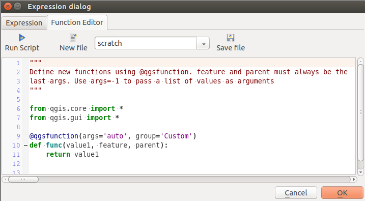
The Function Editor tab
The function editor will create new Python files in .qgis2\python\expressions folder and will auto load all functions defined when starting QGIS. Be aware that new functions are only saved in the expressions folder and not in the project file. If you have a project that uses one of your custom functions you will need to also share the .py file in the expressions folder.
Aqui há um breve exemplo de como criar suas próprias funções:
@qgsfunction(args="auto", group='Custom')
def myfunc(value1, value2, feature, parent):
    pass
The short example creates a function myfunc that will give you a function with two values. When using the args='auto' function argument the number of function arguments required will be calculated by the number of arguments the function has been defined with in Python (minus 2 - feature, and parent).
This function then can be used with the following expression:
myfunc('test1', 'test2')
Your function will be implemented in the Custom functions group of the Expression tab after using the Run Script button.
Further information about creating Python code can be found in the Passo-a-passo para desenvolvedor PyQGIS.
The function editor is not only limited to working with the field calculator, it can be found whenever you work with expressions.