Services
QGIS Server supports some vendor parameters and requests that greatly enhance the possibilities of customising its behavior. The following paragraphs list the vendor parameters and the environment variables supported by the server.
Web Map Service (WMS)
GetMap
In the WMS GetMap request, QGIS Server accepts a couple of extra parameters in addition to the standard parameters according to the OGC WMS 1.3.0 specification:
DPI parameter: The DPI parameter can be used to specify the requested output resolution.
Example:
http://localhost/cgi-bin/qgis_mapserv.fcgi?REQUEST=GetMap&DPI=300&...
IMAGE_QUALITY parameter is only used for JPEG images. By default, the JPEG compression is -1. You can change the default per QGIS project in the OWS Server ‣ WMS capabilities menu of the Project ‣ Project Properties dialog. If you want to override it in a GetMap request you can do it using the IMAGE_QUALITY parameter:
http://localhost/cgi-bin/qgis_mapserv.fcgi?\
 REQUEST=GetMap&FORMAT=image/jpeg&IMAGE_QUALITY=65&...
image/png; mode= can be used to override the png format. You can choose between image/png; mode=16bit, image/png; mode=8bit and image/png; mode=1bit. This can shrink the output image size quite a bit. Example:
http://localhost/cgi-bin/qgis_mapserv.fcgi?\
 REQUEST=GetMap&FORMAT=image/png; mode=8bit&...
OPACITIES parameter: Opacity can be set on layer or group level. Allowed values range from 0 (fully transparent) to 255 (fully opaque).
Example:
http://localhost/cgi-bin/qgis_mapserv.fcgi?\
  REQUEST=GetMap&LAYERS=mylayer1,mylayer2&OPACITIES=125,200&...
FILTER parameter: Subsets of layers can be selected with the FILTER parameter. Syntax is basically the same as for the QGIS subset string. However, there are some restrictions to avoid SQL injections into databases via QGIS server:
Text strings need to be enclosed with quotes (single quotes for strings, double quotes for attributes) A space between each word / special character is mandatory. Allowed Keywords and special characters are ‘AND’,’OR’,’IN’,’=’,’<’,’>=’, ‘>’,’>=’,’!=*,’(‘,’)’. Semicolons in string expressions are not allowed
Example:
http://myserver.com/cgi/qgis_mapserv.fcgi?REQUEST=GetMap&LAYERS=mylayer1,mylayer2&FILTER=mylayer1:"OBJECTID" = 3;mylayer2:'text' = 'blabla'&....
Nota
It is possible to make attribute searches via GetFeatureInfo and omit the X/Y parameter if a FILTER is there. QGIS server then returns info about the matching features and generates a combined bounding box in the xml output.
SELECTION parameter: The SELECTION parameter can highlight features from one or more layers. Vector features can be selected by passing comma separated lists with feature ids in GetMap and GetPrint.
Example:
http://myserver.com/cgi/qgis_mapserv.fcgi?REQUEST=GetMap&LAYERS=mylayer1,mylayer2&SELECTION=mylayer1:3,6,9;mylayer2:1,5,6&...
The following image presents the response from a GetMap request using the SELECTION option e.g. http://myserver.com/...&SELECTION=countries:171,65. As those features id’s correspond in the source dataset to France and Romania they’re highlighted in yellow.
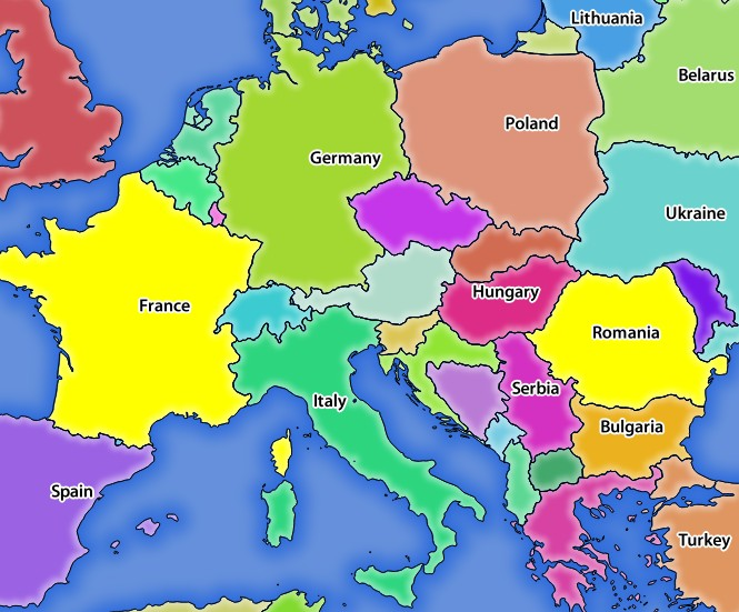
Server response to a GetMap request with SELECTION parameter
It is possible to export layers in the DXF format using the GetMap Request. Only layers that have read access in the WFS service are exported in the DXF format. Here is a valid REQUEST and a documentation of the available parameters:
http://your.server.address/wms/liegenschaftsentwaesserung/abwasser_werkplan?SERVICE=WMS&VERSION=1.3.0&REQUEST=GetMap&LAYERS=Haltungen,Normschacht,Spezialbauwerke&STYLES=&CRS=EPSG%3A21781&BBOX=696136.28844801,245797.12108743,696318.91114315,245939.25832905&WIDTH=1042&HEIGHT=811&FORMAT=application/dxf&FORMAT_OPTIONS=MODE:SYMBOLLAYERSYMBOLOGY;SCALE:250&FILE_NAME=werkplan_abwasser.dxf
Parameters:
- FORMAT=application/dxf
- FILE_NAME=yoursuggested_file_name_for_download.dxf
- FORMAT_OPTIONS=see options below, key:value pairs separated by Semicolon
FORMAT_OPTIONS Parameters:
- SCALE:scale to be used for symbology rules, filters and styles (not an actual scaling of the data - data remains in the original scale).
- MODE:NOSYMBOLOGY|FEATURESYMBOLOGY|SYMBOLLAYERSYMBOLOGY corresponds to the three export options offered in the QGIS Desktop DXF export dialog.
- LAYERSATTRIBUTES:yourcolumn_with_values_to_be_used_for_dxf_layernames - if not specified, the original QGIS layer names are used.
- USE_TITLE_AS_LAYERNAME if enabled, the title of the layer will be used as layer name.
GetFeatureInfo
QGIS Server WMS GetFeatureInfo requests supports the following extra optional parameters to define the tolerance for point, line and polygon layers:
- FI_POINT_TOLERANCE parameter: Tolerance for point layers GetFeatureInfo request, in pixels.
- FI_LINE_TOLERANCE parameter: Tolerance for linestring layers GetFeatureInfo request, in pixels.
- FI_POLYGON_TOLERANCE parameter: Tolerance for polygon layers GetFeatureInfo request, in pixels.
GetPrint
QGIS server has the capability to create print composer output in pdf or pixel format. Print composer windows in the published project are used as templates. In the GetPrint request, the client has the possibility to specify parameters of the contained composer maps and labels.
Example:
The published project has two composer maps. In the GetProjectSettings response, they are listed as possible print templates:
<WMS_Capabilities>
...
<ComposerTemplates xsi:type="wms:_ExtendedCapabilities">
<ComposerTemplate width="297" height="210" name="Druckzusammenstellung 1">
<ComposerMap width="171" height="133" name="map0"/>
<ComposerMap width="49" height="46" name="map1"/></ComposerTemplate>
</ComposerTemplates>
...
</WMS_Capabilities>
The client has now the information to request a print output:
http://myserver.com/cgi/qgis_mapserv.fcgi?...&REQUEST=GetPrint&TEMPLATE=Druckzusammenstellung 1&map0:EXTENT=xmin,ymin,xmax,ymax&map0:ROTATION=45&FORMAT=pdf&DPI=300
Parameters in the GetPrint request are:
- <map_id>:EXTENT gives the extent for a composer map as xmin,ymin,xmax,ymax.
- <map_id>:ROTATION map rotation in degrees
- <map_id>:GRID_INTERVAL_X, <map_id>:GRID_INTERVAL_Y Grid line density for a composer map in x- and y-direction
- <map_id>:SCALE Sets a mapscale to a composer map. This is useful to ensure scale based visibility of layers and labels even if client and server may have different algorithms to calculate the scale denominator
- <map_id>:LAYERS, <map_id>:STYLES possibility to give layer and styles list for composer map (useful in case of overview maps which should have only a subset of layers)
GetLegendGraphics
Several additional parameters are available to change the size of the legend elements:
- BOXSPACE space between legend frame and content (mm)
- LAYERSPACE versical space between layers (mm)
- LAYERTITLESPACE vertical space between layer title and items following (mm)
- SYMBOLSPACE vertical space between symbol and item following (mm)
- ICONLABELSPACE horizontal space between symbol and label text (mm)
- SYMBOLWIDTH width of the symbol preview (mm)
- SYMBOLHEIGHT height of the symbol preview (mm)
These parameters change the font properties for layer titles and item labels:
- LAYERFONTFAMILY / ITEMFONTFAMILY font family for layer title / item text
- LAYERFONTBOLD / ITEMFONTBOLD ‘TRUE’ to use a bold font
- LAYERFONTSIZE / ITEMFONTSIZE Font size in point
- LAYERFONTITALIC / ITEMFONTITALIC ‘TRUE’ to use italic font
- LAYERFONTCOLOR / ITEMFONTCOLOR Hex color code (e.g. #FF0000 for red)
- LAYERTITLE / RULELABEL (from QGIS 2.4) set them to ‘FALSE’ to get only the legend graphics without labels
Contest based legend. These parameters let the client request a legend showing only the symbols for the features falling into the requested area:
- BBOX the geographical area for which the legend should be built
- CRS / SRS the coordinate reference system adopted to define the BBOX coordinates
- WIDTH / HEIGHT if set these should match those defined for the GetMap request, to let QGIS Server scale symbols according to the map view image size.
Contest based legend features are based on the UMN MapServer implementation:
GetProjectSettings
This request type works similar to GetCapabilities, but it is more specific to QGIS Server and allows a client to read additional information which is not available in the GetCapabilities output:
- initial visibility of layers
- information about vector attributes and their edit types
- information about layer order and drawing order
- list of layers published in WFS
Web Feature Service (WFS)
GetFeature
In the WFS GetFeature request, QGIS Server accepts two extra parameters in addition to the standard parameters according to the OGC WFS 1.0.0 specification:
- GeometryName parameter: this parameter can be used to get the extent or the centroid as the geometry or no geometry if none if used (ie attribute only). Allowed values are extent, centroid or none.
- StartIndex parameter: STARTINDEX is standard in WFS 2.0, but it’s an extension for WFS 1.0.0 which is the only version implemented in QGIS Server. STARTINDEX can be used to skip some features in the result set and in combination with MAXFEATURES will provide for the ability to use WFS GetFeature to page through results. Note that STARTINDEX=0 means start with
Extra parameters supported by all request types
FILE_NAME parameter: if set, the server response will be sent to the client as a file attachment with the specified file name.
MAP parameter: Similar to MapServer, the MAP parameter can be used to specify the path to the QGIS project file. You can specify an absolute path or a path relative to the location of the server executable (qgis_mapserv.fcgi). If not specified, QGIS Server searches for .qgs files in the directory where the server executable is located.
Example:
http://localhost/cgi-bin/qgis_mapserv.fcgi?\
  REQUEST=GetMap&MAP=/home/qgis/mymap.qgs&...
Nota
You can define a QGIS_PROJECT_FILE as an environment variable to tell the server executable where to find the QGIS project file. This variable will be the location where QGIS will look for the project file. If not defined it will use the MAP parameter in the request and finally look at the server executable directory.
the first feature, skipping none.
REDLINING
This feature is available and can be used with GetMap and GetPrint requests.
The redlining feature can be used to pass geometries and labels in the request which are overlapped by the server over the standard returned image (map). This permits the user to put emphasis or maybe add some comments (labels) to some areas, locations etc. that are not in the standard map.
The request is in the format:
http://qgisplatform.demo/cgi-bin/qgis_mapserv.fcgi?map=/world.qgs&SERVICE=WMS&VERSION=1.3.0&
REQUEST=GetMap
...
&HIGHLIGHT_GEOM=POLYGON((590000 5647000, 590000 6110620, 2500000 6110620, 2500000 5647000, 590000 5647000))
&HIGHLIGHT_SYMBOL=<StyledLayerDescriptor><UserStyle><Name>Highlight</Name><FeatureTypeStyle><Rule><Name>Symbol</Name><LineSymbolizer><Stroke><SvgParameter name="stroke">%23ea1173</SvgParameter><SvgParameter name="stroke-opacity">1</SvgParameter><SvgParameter name="stroke-width">1.6</SvgParameter></Stroke></LineSymbolizer></Rule></FeatureTypeStyle></UserStyle></StyledLayerDescriptor>
&HIGHLIGHT_LABELSTRING=Write label here
&HIGHLIGHT_LABELSIZE=16
&HIGHLIGHT_LABELCOLOR=%23000000
&HIGHLIGHT_LABELBUFFERCOLOR=%23FFFFFF
&HIGHLIGHT_LABELBUFFERSIZE=1.5
Here is the image outputed by the above request in which a polygon and a label are drawn on top of the normal map:
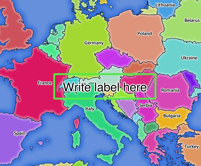
Server response to a GetMap request with redlining parameters
You can see there are several parameters in this request:
- HIGHLIGHT_GEOM: You can add POINT, MULTILINESTRING, POLYGON etc. It supports multipart geometries. Here is an example: HIGHLIGHT_GEOM=MULTILINESTRING((0 0, 0 1, 1 1)). The coordinates should be in the CRS of the GetMap/GetPrint request.
- HIGHLIGHT_SYMBOL: This controls how the geometry is outlined and you can change the stroke width, color and opacity.
- HIGHLIGHT_LABELSTRING: You can pass your labeling text to this parameter.
- HIGHLIGHT_LABELSIZE: This parameter controls the size of the label.
- HIGHLIGHT_LABELCOLOR: This parameter controls the label color.
- HIGHLIGHT_LABELBUFFERCOLOR: This parameter controls the label buffer color.
- HIGHLIGHT_LABELBUFFERSIZE: This parameter controls the label buffer size.