Important
Traducerea este un efort al comunității, la care puteți să vă alăturați. În prezent, această pagină este tradusă 45.00%.
13.2. Analiza Raster
13.2.1. Calculatorul Raster
The in the menu allows you to perform calculations on the basis of existing raster pixel values (see Fig. 13.33). The results are written to a new raster layer in a GDAL-supported format.
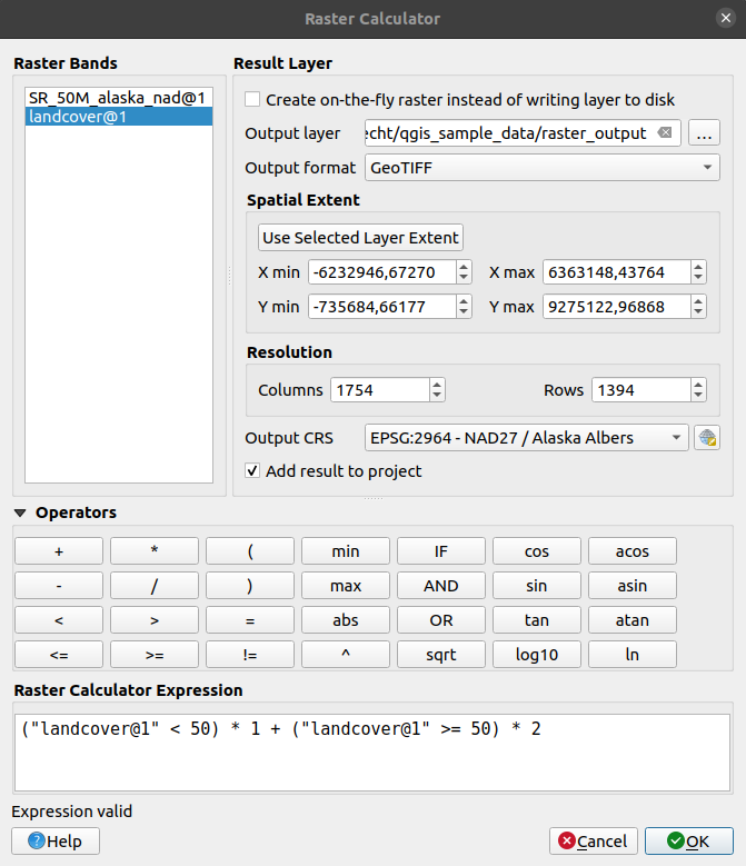
Fig. 13.33 Calculatorul Raster
The Raster bands list contains all loaded raster layers that can be used. To add a raster to the raster calculator expression field, double click its name in the Fields list. You can then use the operators to construct calculation expressions, or you can just type them into the box.
In the Result layer section, you will need to define an output layer. You can:
 Create on-the-fly raster instead of writing layer to disk:
If unchecked, the output is stored on the disk as a new plain file. An Output layer path and an Output format are required.
If checked, a virtual raster layer, i.e. a raster layer defined by its URI and whose pixels are calculated on-the-fly, is created. It’s not a new file on disk; the virtual layer is still connected to the rasters used in the calculation meaning that deleting or moving these rasters would break it. A Layer name can be provided, otherwise the calculation expression is used as such. Removing the virtual layer from the project deletes it, and it can be made persistent in file using the layer contextual menu.
Define the Spatial extent of the calculation using the extent selector widget.
Set the Resolution of the layer using columns and rows number. If the input layer has a different resolution, the values will be resampled with the nearest neighbor algorithm.
Enable the
Create Options to define additional raster creation options.
These options let you control how the output file is structured and compressed,
including format, compression method, and other driver-specific settings.
See more at Raster driver options.With the
Add result to project checkbox, the result layer
will automatically be added to the legend area and can be visualized.
Checked by default for virtual rasters.
The Operators section contains all available operators. To add an operator
to the raster calculator expression box, click the appropriate button. Mathematical
calculations (+, -, *, … ) and trigonometric functions (sin,
cos, tan, … ) are available. Conditional expressions (=, !=,
<, >=, … ) return either 0 for false or 1 for true, and therefore can be
used with other operators and functions.
Vezi și
Calculator raster and Raster calculator (virtual) algorithms
13.2.1.1. Raster calculator expression
The dialog
The Raster calculator expression dialog provides means to write expressions for pixels calculations between a set of raster layers.
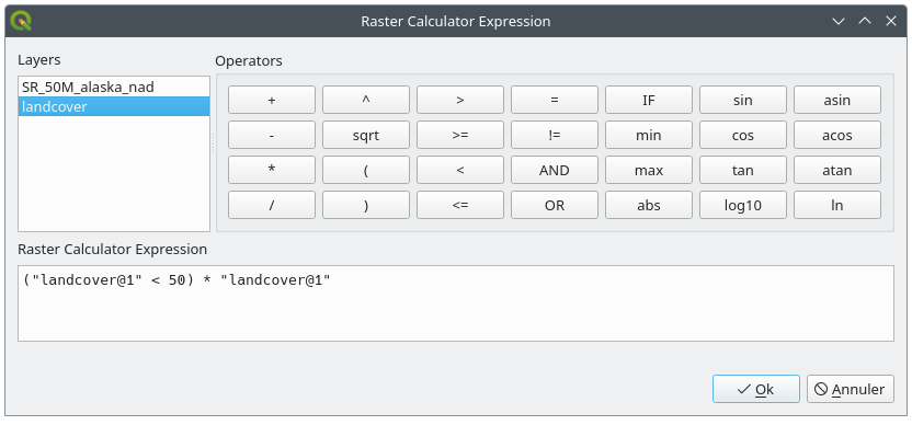
Fig. 13.34 Raster Expression Calculator
Layers: Shows the list of all raster layers loaded in the legend. These can be used to fill the expression box (double click to add). Raster layers are referred by their name and the number of the band:
layer_name@band_number. For instance, the first band from a layer namedDEMwill be referred asDEM@1.Operatori: conține un număr de operatori de calcul dedicați manipulării pixelilor:
Aritmetici:
+,-,*,sqrt,abs,ln, …Trigonometrici:
sin,cos,tan, …Comparativi:
=,!=,<,>=, …Logici:
IF,AND,OR,(,)Statistici:
min,max
To add an operator to the raster calculator expression box, click the appropriate button.
Raster calculator expression is the area in which the expression is composed
Exemple
Conversia valorilor de elevație de la metri la picioare
Pentru crearea unui raster de elevație în feet dintr-un raster în metri, trebuie să utilizați factorul de conversie de la metri la picioare: 3.28. Expresia este:
"elevation@1" * 3.28
Folosirea unei măști
Dacă doriți să mascați unele părți dintr-un raster - să zicem, de exemplu, pentru că vă interesează doar altitudinile de peste 0 metri - puteți utiliza următoarea expresie pentru a crea o mască și pentru a aplica rezultatul unui raster, într-un singur pas.
("elevation@1" >= 0) * "elevation@1"
In other words, for every cell greater than or equal to 0 the conditional expression evaluates to 1, which keeps the original value by multiplying it by 1. Otherwise the conditional expression evaluates to 0, which sets the raster value to 0. This creates the mask on the fly.
Classify a Raster
În cazul în care doriți să clasificați un raster - să zicem, de exemplu, în două clase de altitudine, puteți utiliza următoarea expresie pentru a crea un raster cu două valori, 1 și 2, într-un singur pas.
("elevation@1" < 50) * 1 + ("elevation@1" >= 50) * 2
Cu alte cuvinte, pentru fiecare celulă mai mică de 50, valoarea sa va fi setată la 1. Pentru fiecare celulă mai mare sau egală cu 50 valoarea sa va fi setată la 2.
Or you can use the IF operator.
if ( elevation@1 < 50 , 1 , 2 )