Important
Traducerea este un efort al comunității, la care puteți să vă alăturați. În prezent, această pagină este tradusă 44.86%.
5.4. Lesson: Actions
Now that you have seen a default action in the previous lesson, it is time to define your own actions.
An action is something that happens when you click on a feature. It can add a lot of extra functionality to your map, allowing you to retrieve additional information about an object, for example. Assigning actions can add a whole new dimension to your map!
Scopul acestei lecții: De a afla cum să adăugați acțiuni particularizate.
In this lesson you will use the school_property layer you
created previously.
The sample data include photos of each of the three properties you
digitized.
What we are going to do is to associate each property with its image.
Then we will create an action that will open the image for a property
when clicking on the property.
5.4.1. ★☆☆ Procedați în mod similar: Adăugarea unui Câmp pentru Imagini
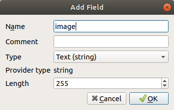
The school_property layer has no way to associate an image with a
property yet. First we will create a field for this purpose.
Deschideți dialogul Layer Properties.
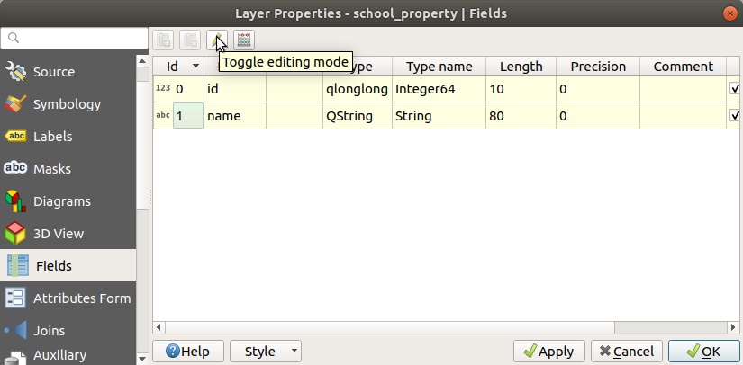
Dați clic pe fila Fields.
Comutați în modul de editare:
Adăugați o nouă coloană:
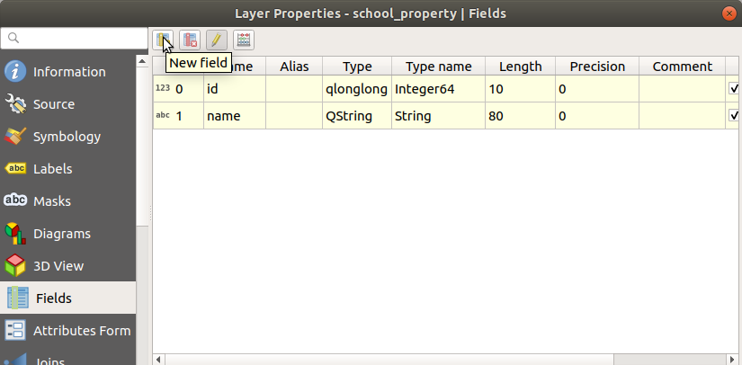
Introduceți valorile de mai jos:
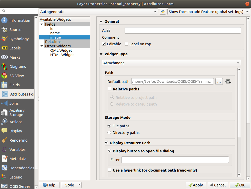
After the field has been created, move to the Attributes Form tab and select the
imagefield.Set Widget Type to Attachment:
Click OK in the Layer Properties dialog.
Use the
 Identify Features tool to click on one of the three
features in the
Identify Features tool to click on one of the three
features in the school_propertylayer.Since you are still in edit mode, the dialog should be active and look like this:
Clic pe butonul de răsfoire (… de lângă câmpul imagine).
Select the path for your image. The images are in
exercise_data/school_property_photos/and are named the same as the features they should be associated with.Clic pe OK
Asociați toate imaginile cu entitățile corecte folosind această metodă.
Salvați modificările și ieșiți din modul de editare.
5.4.2. ★☆☆ Procedați în mod similar: Crearea unei Acțiuni
Open the Actions tab for the
school_propertylayer, and click on the Add a new action button.
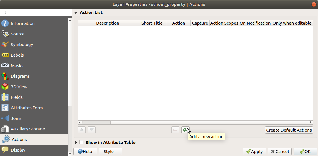
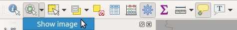
In the Add New Action dialog, enter the words
Show Imageinto the Description field: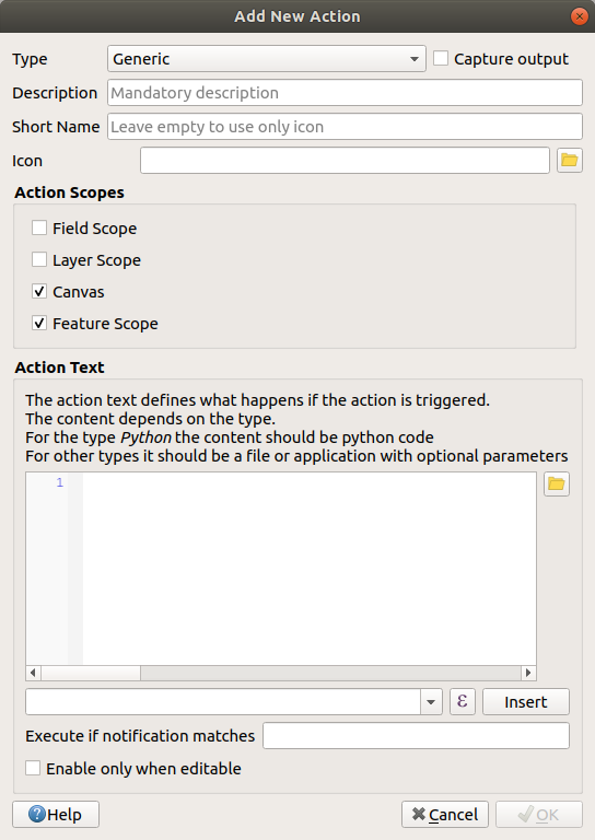
Ceea ce veți face în continuare diferă în funcție de sistemul de operare, asa că alegeți un curs adecvat:
Windows
Dați clic pe meniul vertical Type și alegeți Open.
Ubuntu Linux
Under Action, write
eogfor the Gnome Image Viewer, or writedisplayto use ImageMagick. Remember to put a space after the command!macOS
Clic pe caseta Type, apoi alegeți Mac.
Under Action, write
open. Remember to put a space after the command!
Now you can continue writing the command.
Vreți să deschideți imaginea, si QGIS știe unde se află. Tot ce rămâne de făcut este să îi spuneți Action unde se află imaginea.
Selectați image din listă:
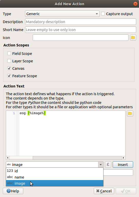
Click the Insert field button. QGIS will add the phrase
[% "image" %]in the Action Text field.Click the OK button to close the Add New Action dialog
Click OK to close the Layer Properties dialog
Now it is time to test the new action:
Click on the
school_propertylayer in the Layers panel so that it is highlighted.Find the
 Run feature action button (in the
Attributes Toolbar).
Run feature action button (in the
Attributes Toolbar).Click on the down arrow to the right of this button. There is only one action defined for this layer so far, which is the one you just created.
Apăsați butonul pentru a activa instrumentul.
Folosind acest instrument, faceți clic pe oricare din cele trei proprietăți școlare.
The image for that property should open.
5.4.3. ★☆☆ Procedați în mod similar: Căutarea pe Internet
Let’s say we are looking at the map and want to know more about the area that a farm is in. Suppose you know nothing of the area in question and want to find general information about it. Your first impulse, considering that you’re using a computer right now, would probably be to Google the name of the area. So let’s tell QGIS to do that automatically for us!
Open the attribute table for the
landuselayer.We will be using the
namefield for each of our landuse areas to search Google.Închideți tabelul de atribute.
Mergeți înapoi la Acțiuni în Proprietățile Stratului.
Click on the Create Default Actions button to add a number of pre-defined actions.
Remove all the actions but the Open URL action with the short name Search Web using the
 Remove the selected action button below.
Double-click on the remaining action to edit it
Change the Description to
Google Search, and remove the content of the Short Name field.Make sure that Canvas is among the checked Action scopes.
Ceea ce veți face în continuare diferă în funcție de sistemul de operare, asa că alegeți un curs adecvat:
Windows
Sub Tip, alegeți Deschidere. Acest lucru va spune Windows-ului să deschidă o adresă de Internet din browser-ul implicit, cum ar fi Internet Explorer.
Ubuntu Linux
Under Action, write
xdg-open. This will tell Ubuntu to open an Internet address in your default browser, such as Chrome or Firefox.macOS
Under Action, write
open. This will tell macOS to open an Internet address in your default browser, such as Safari.
Now you can continue writing the command
Orice comandă ați folosit mai sus, trebuie să îi spuneți ce adresă să deschidă în continuare. Vreți să accesați Google și să căutați automat o expresie.
Usually when you use Google, you enter your search phrase into the Google Search bar. But in this case, you want your computer to do this for you. The way you tell Google to search for something (if you don’t want to use its search bar directly) is by giving your Internet browser the address
https://www.google.com/search?q=SEARCH_PHRASE, whereSEARCH_PHRASE`is what you want to search for. Since we don’t know what phrase to search for yet, we will just enter the first part (without the search phrase).In the Action field, write
https://www.google.com/search?q=. Remember to add a space after your initial command before writing this in!Now you want QGIS to tell the browser to tell Google to search for the value of
namefor any feature that you could click on.Selectați câmpul name.
Click Insert button:
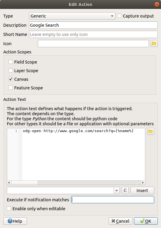
What this means is that QGIS is going to open the browser and send it to the address
https://www.google.com/search?q=[% "name" %].[% "name" %]tells QGIS to use the contents of thenamefield as the phrase to search for.So if, for example, the landuse area you click on is named
Marloth Nature Reserve, QGIS is going to send the browser tohttps://www.google.com/search?q=Marloth%20Nature%20Reserve, which will cause your browser to visit Google, which will in turn search for „Marloth Nature Reserve”.If you have not done so already, set everything up as explained above.
Click the OK button to close the Add New Action dialog
Click OK to close the Layer Properties dialog
Acum vom testa noua versiune.
With the
landuselayer active in the Layers panel, click on the down arrow to the right of the Run feature action button, and select the
only action (Google Search) defined for this layer.Click on any landuse area you can see on the map. Your browser will now open, and will start a Google search for the place that is recorded as that area’s
namevalue.
Notă
În cazul în care acțiunea nu funcționează, verificați dacă totul a fost introdus corect; erorile de introducere sunt comune pentru această activitate!
5.4.4. ★★★ Follow Along: Open a Webpage Directly in QGIS
Above, you’ve seen how to open a webpage in an external browser. There are some shortcomings with this approach in that it adds an unknowable dependency – will the end-user have the software required to execute the action on their system? As you’ve seen, they don’t necessarily even have the same kind of base command for the same kind of action, if you don’t know which OS they will be using. With some OS versions, the above commands to open the browser might not work at all. This could be an insurmountable problem.
However, QGIS sits on top of the incredibly powerful and versatile Qt library. Also, QGIS actions can be arbitrary, tokenized (i.e. using variable information based on the contents of a field attribute) Python commands!
Now you will see how to use a python action to show a web page. It is the same general idea as opening a site in an external browser, but it requires no browser on the user’s system since it uses the Qt QWebView class (which is a webkit based html widget) to display the content in a pop-up window.
Let us use Wikipedia this time. So the URL you request will look like this:
https://wikipedia.org/wiki/SEARCH_PHRASE
Pentru a crea acțiunea stratului:
Deschideți dialogul Proprietăților Stratului și mergeți la fila Actions.
Setați o nouă acțiune, folosind următoarele proprietăți pentru acțiune:
Tip:
PythonDescriere:
WikipediaScope:
Feature,CanvasAction Text:
from qgis.PyQt.QtCore import QUrl
from qgis.PyQt.QtWebKitWidgets import QWebView

myWV = QWebView(None)
myWV.load(QUrl('https://wikipedia.org/wiki/[%name%]'))
myWV.show()
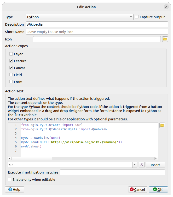
Aici se întâmplă mai multe lucruri:
[%name%]will be replaced by the actual attribute value when the action is invoked (as before).The code simply creates a new
QWebViewinstance, sets its URL, and then callsshow()on it to make it visible as a window on the user’s desktop.
You could also use this approach to display an image without requiring that the users have a particular image viewer on their system.
Try to use the methods described above to load a Wikipedia page using the Wikipedia action you just created.
5.4.5. În concluzie
Actions allow you to give your map extra functionality, useful to the end-user who views the same map in QGIS. Due to the fact that processes called can be shell commands for any operating system, as well as Python, the sky is the limit in terms of the functions you could incorporate!
5.4.6. Ce urmează?
Now that you’ve done all kinds of vector data creation, you will learn how to analyze the data to solve problems. That is the topic of the next module.