Fontos
A fordítás közösségi munka, amihez itt tud csatlakozni. Ennek az oldalnak eddig 49.28%-a van lefordítva.
24.1.28. Vector selection
24.1.28.1. Extract by attribute
Creates two vector layers from an input layer: one will contain only matching features while the second will contain all the non-matching features.
The criteria for adding features to the resulting layer is based on the values of an attribute from the input layer.
Lásd még
Paraméterek
Címke |
Név |
Típus |
Leírás |
|---|---|---|---|
Bemeneti réteg |
|
[vector: any] |
Layer to extract features from. |
Selection attribute |
|
[tablefield: any] |
Filtering field of the layer |
Operator |
|
[felsorolás] Alapértelmezett: 0 |
Many different operators are available:
|
Value Optional |
|
[karakterlánc] |
Value to be evaluated |
Extracted (attribute) |
|
[same as input] Default: |
Specify the output vector layer for matching features. One of:
A fájl kódolása is módosítható itt. |
Extracted (non-matching) |
|
[same as input] Default: |
Specify the output vector layer for non-matching features. One of:
A fájl kódolása is módosítható itt. |
Kimenetek
Címke |
Név |
Típus |
Leírás |
|---|---|---|---|
Extracted (attribute) |
|
[same as input] |
Vector layer with matching features from the input layer |
Extracted (non-matching) |
|
[same as input] |
Vector layer with non-matching features from the input layer |
Python kód
Algorithm ID: native:extractbyattribute
import processing
processing.run("algorithm_id", {parameter_dictionary})
Az algoritmus azonosító akkor jelenik meg, ha az egérmutatót az algoritmus fölé viszi a Feldolgozás eszköztáron. A paraméterszótár tartalmazza a paraméter NAME-eket és érékeket. A feldolgozási algoritmusok Python konzolról történő futtatásával kapcsolatos részletekért lásd a Using processing algorithms from the console fejezetet.
24.1.28.2. Extract by expression
Creates two vector layers from an input layer: one will contain only matching features while the second will contain all the non-matching features.
The criteria for adding features to the resulting layer is based on a QGIS expression. For more information about expressions see the Kifejezések.
Lásd még
Paraméterek
Címke |
Név |
Típus |
Leírás |
|---|---|---|---|
Bemeneti réteg |
|
[vector: any] |
Input vector layer |
Expression |
|
[expression] |
Expression to filter the vector layer |
Matching features |
|
[same as input] Default: |
Specify the output vector layer for matching features. One of:
A fájl kódolása is módosítható itt. |
Non-matching |
|
[same as input] Default: |
Specify the output vector layer for non-matching features. One of:
A fájl kódolása is módosítható itt. |
Kimenetek
Címke |
Név |
Típus |
Leírás |
|---|---|---|---|
Matching features |
|
[same as input] |
Vector layer with matching features from the input layer |
Non-matching |
|
[same as input] |
Vector layer with non-matching features from the input layer |
Python kód
Algorithm ID: native:extractbyexpression
import processing
processing.run("algorithm_id", {parameter_dictionary})
Az algoritmus azonosító akkor jelenik meg, ha az egérmutatót az algoritmus fölé viszi a Feldolgozás eszköztáron. A paraméterszótár tartalmazza a paraméter NAME-eket és érékeket. A feldolgozási algoritmusok Python konzolról történő futtatásával kapcsolatos részletekért lásd a Using processing algorithms from the console fejezetet.
24.1.28.3. Extract by location
Creates a new vector layer that only contains matching features from an input layer.
The criteria for adding features to the resulting layer is based on the spatial relationship between each feature and the features in an additional layer.
Lásd még
Exploring spatial relations
Geometric predicates are boolean functions used to determine the spatial relation a feature has with another by comparing whether and how their geometries share a portion of space.
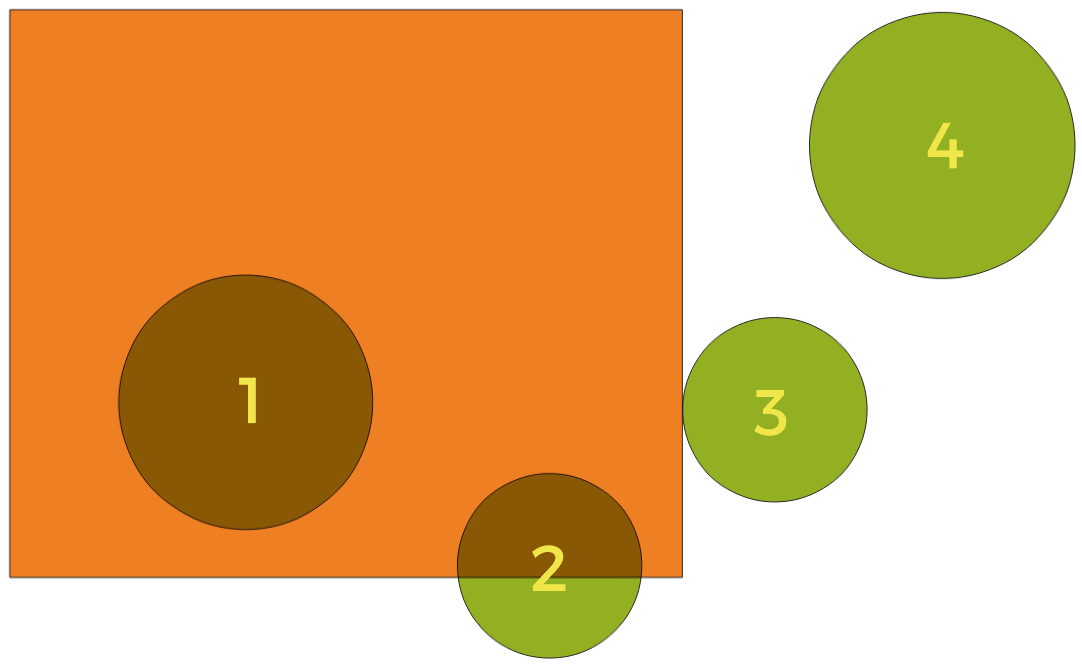
24.176. ábra Looking for spatial relations between layers
Using the figure above, we are looking for the green circles by spatially comparing them to the orange rectangle feature. Available geometric predicates are:
- Intersect
Tests whether a geometry intersects another. Returns 1 (true) if the geometries spatially intersect (share any portion of space - overlap or touch) and 0 if they don’t. In the picture above, this will return circles 1, 2 and 3.
- Contain
Returns 1 (true) if and only if no points of b lie in the exterior of a, and at least one point of the interior of b lies in the interior of a. In the picture, no circle is returned, but the rectangle would be if you would look for it the other way around, as it contains circle 1 completely. This is the opposite of are within.
- Disjoint
Returns 1 (true) if the geometries do not share any portion of space (no overlap, not touching). Only circle 4 is returned.
- Equal
Returns 1 (true) if and only if geometries are exactly the same. No circles will be returned.
- Touch
Tests whether a geometry touches another. Returns 1 (true) if the geometries have at least one point in common, but their interiors do not intersect. Only circle 3 is returned.
- Overlap
Tests whether a geometry overlaps another. Returns 1 (true) if the geometries share space, are of the same dimension, but are not completely contained by each other. Only circle 2 is returned.
- Are within
Tests whether a geometry is within another. Returns 1 (true) if geometry a is completely inside geometry b. Only circle 1 is returned.
- Cross
Returns 1 (true) if the supplied geometries have some, but not all, interior points in common and the actual crossing is of a lower dimension than the highest supplied geometry. For example, a line crossing a polygon will cross as a line (true). Two lines crossing will cross as a point (true). Two polygons cross as a polygon (false). In the picture, no circles will be returned.
Paraméterek
Címke |
Név |
Típus |
Leírás |
|---|---|---|---|
Extract features from |
|
[vector: geometry] |
Input vector layer |
Where the features (geometric predicate) |
|
[enumeration] [list] Default: [0] |
Type of spatial relation the input feature should have with an intersect feature so that it could be selected. One or more of:
If more than one condition is chosen, at least one of them (OR operation) has to be met for a feature to be extracted. |
By comparing to the features from |
|
[vector: geometry] |
Intersection vector layer |
Extracted (location) |
|
[same as input] Alapértelmezett: |
Specify the output vector layer for the features that have the chosen spatial relationship(s) with one or more features in the comparison layer. One of:
A fájl kódolása is módosítható itt. |
Kimenetek
Címke |
Név |
Típus |
Leírás |
|---|---|---|---|
Extracted (location) |
|
[same as input] |
Vector layer with features from the input layer that have the chosen spatial relationship(s) with one or more features in the comparison layer. |
Python kód
Algorithm ID: native:extractbylocation
import processing
processing.run("algorithm_id", {parameter_dictionary})
Az algoritmus azonosító akkor jelenik meg, ha az egérmutatót az algoritmus fölé viszi a Feldolgozás eszköztáron. A paraméterszótár tartalmazza a paraméter NAME-eket és érékeket. A feldolgozási algoritmusok Python konzolról történő futtatásával kapcsolatos részletekért lásd a Using processing algorithms from the console fejezetet.
24.1.28.4. Extract within distance
Creates a new vector layer that only contains matching features from an input layer. Features are copied wherever they are within the specified maximum distance from the features in an additional reference layer.
Lásd még
Paraméterek
Címke |
Név |
Típus |
Leírás |
|---|---|---|---|
Extract features from |
|
[vector: geometry] |
Input vector layer to copy features from |
By comparing to the features from |
|
[vector: geometry] |
Vector layer whose features closeness is used |
Where the features are within |
|
[numeric: double] Default: 100.0 |
The maximum distance around reference features to select input features within |
Modify current selection by |
|
[felsorolás] Alapértelmezett: 0 |
How the selection of the algorithm should be managed. One of:
|
Extracted (location) |
|
[same as input] Alapértelmezett: |
Specify the output vector layer for the features that are within the set distance from reference features. One of:
A fájl kódolása is módosítható itt. |

Kimenetek
Címke |
Név |
Típus |
Leírás |
|---|---|---|---|
Extracted (location) |
|
[same as input] |
Vector layer with features from the input layer matching the condition of distance from reference features |
Python kód
Algorithm ID: native:extractwithindistance
import processing
processing.run("algorithm_id", {parameter_dictionary})
Az algoritmus azonosító akkor jelenik meg, ha az egérmutatót az algoritmus fölé viszi a Feldolgozás eszköztáron. A paraméterszótár tartalmazza a paraméter NAME-eket és érékeket. A feldolgozási algoritmusok Python konzolról történő futtatásával kapcsolatos részletekért lásd a Using processing algorithms from the console fejezetet.
24.1.28.5. Szűrés geometriatípus szerint
Filters features by their geometry type. Incoming features will be directed to different outputs based on whether they have a point, line or polygon geometry.
Paraméterek
Címke |
Név |
Típus |
Leírás |
|---|---|---|---|
Bemeneti réteg |
|
[vector: any] |
Layer to evaluate |
Kimenetek
Címke |
Név |
Típus |
Leírás |
|---|---|---|---|
Point features Optional |
|
[vector: point] |
Layer with points |
Vonalelemek Optional |
|
[vektor: vonal] |
Layer with lines |
Polygon features Optional |
|
[vector: poligon] |
Layer with polygons |
Features with no geometry Optional |
|
[vector: table] |
Geometry-less vector layer |
Python kód
Algorithm ID: native:filterbygeometry
import processing
processing.run("algorithm_id", {parameter_dictionary})
Az algoritmus azonosító akkor jelenik meg, ha az egérmutatót az algoritmus fölé viszi a Feldolgozás eszköztáron. A paraméterszótár tartalmazza a paraméter NAME-eket és érékeket. A feldolgozási algoritmusok Python konzolról történő futtatásával kapcsolatos részletekért lásd a Using processing algorithms from the console fejezetet.
24.1.28.6. Random extract
Takes a vector layer and generates a new one that contains only a subset of the features in the input layer.
The subset is defined randomly, based on feature IDs, using a percentage or count value to define the total number of features in the subset.
Figyelem
This algorithm drops existing primary keys or FID values and regenerate them in output layers.
Lásd még
Paraméterek
Címke |
Név |
Típus |
Leírás |
|---|---|---|---|
Bemeneti réteg |
|
[vector: any] |
Source vector layer to select the features from |
Módszer |
|
[felsorolás] Alapértelmezett: 0 |
Random selection methods. One of:
|
Number/percentage of selected features |
|
[numerikus: egész szám] Alapértelmezett: 10 |
Number or percentage of features to select |
Extracted (random) |
|
[same as input] Alapértelmezett: |
Specify the output vector layer for the randomly selected features. One of:
A fájl kódolása is módosítható itt. |
Kimenetek
Címke |
Név |
Típus |
Leírás |
|---|---|---|---|
Extracted (random) |
|
[same as input] |
Vector layer containing randomly selected features from the input layer |
Python kód
Algorithm ID: native:randomextract
import processing
processing.run("algorithm_id", {parameter_dictionary})
Az algoritmus azonosító akkor jelenik meg, ha az egérmutatót az algoritmus fölé viszi a Feldolgozás eszköztáron. A paraméterszótár tartalmazza a paraméter NAME-eket és érékeket. A feldolgozási algoritmusok Python konzolról történő futtatásával kapcsolatos részletekért lásd a Using processing algorithms from the console fejezetet.
24.1.28.7. Random extract within subsets
Takes a vector layer and generates a new one that contains only a subset of the features in the input layer.
The subset is defined randomly, based on feature IDs, using a percentage or count value to define the total number of features in the subset. The percentage/count value is not applied to the whole layer, but instead to each category. Categories are defined according to a given attribute.
Lásd még
Paraméterek
Címke |
Név |
Típus |
Leírás |
|---|---|---|---|
Bemeneti réteg |
|
[vector: any] |
Vector layer to select the features from |
ID field |
|
[tablefield: any] |
Category of the source vector layer to select the features from |
Módszer |
|
[felsorolás] Alapértelmezett: 0 |
Random selection method. One of:
|
Number/percentage of selected features |
|
[numerikus: egész szám] Alapértelmezett: 10 |
Number or percentage of features to select |
Extracted (random stratified) |
|
[same as input] Alapértelmezett: |
Specify the output vector layer for the randomly selected features. One of:
A fájl kódolása is módosítható itt. |
Kimenetek
Címke |
Név |
Típus |
Leírás |
|---|---|---|---|
Extracted (random stratified) |
|
[same as input] |
Vector layer containing randomly selected features from the input layer |
Python kód
Algorithm ID: qgis:randomextractwithinsubsets
import processing
processing.run("algorithm_id", {parameter_dictionary})
Az algoritmus azonosító akkor jelenik meg, ha az egérmutatót az algoritmus fölé viszi a Feldolgozás eszköztáron. A paraméterszótár tartalmazza a paraméter NAME-eket és érékeket. A feldolgozási algoritmusok Python konzolról történő futtatásával kapcsolatos részletekért lásd a Using processing algorithms from the console fejezetet.
24.1.28.8. Random selection
Takes a vector layer and selects a subset of its features. No new layer is generated by this algorithm.
The subset is defined randomly, based on feature IDs, using a percentage or count value to define the total number of features in the subset.
Alapértelmezett menüpont:
Lásd még
Paraméterek
Címke |
Név |
Típus |
Leírás |
|---|---|---|---|
Bemeneti réteg |
|
[vector: any] |
Vector layer for the selection |
Módszer |
|
[felsorolás] Alapértelmezett: 0 |
Random selection method. One of:
|
Number/percentage of selected features |
|
[numerikus: egész szám] Alapértelmezett: 10 |
Number or percentage of features to select |
Kimenetek
Címke |
Név |
Típus |
Leírás |
|---|---|---|---|
Bemeneti réteg |
|
[same as input] |
The input layer with features selected |
Python kód
Algorithm ID: qgis:randomselection
import processing
processing.run("algorithm_id", {parameter_dictionary})
Az algoritmus azonosító akkor jelenik meg, ha az egérmutatót az algoritmus fölé viszi a Feldolgozás eszköztáron. A paraméterszótár tartalmazza a paraméter NAME-eket és érékeket. A feldolgozási algoritmusok Python konzolról történő futtatásával kapcsolatos részletekért lásd a Using processing algorithms from the console fejezetet.
24.1.28.9. Random selection within subsets
Takes a vector layer and selects a subset of its features. No new layer is generated by this algorithm.
The subset is defined randomly, based on feature IDs, using a percentage or count value to define the total number of features in the subset.
The percentage/count value is not applied to the whole layer, but instead to each category.
Categories are defined according to a given attribute, which is also specified as an input parameter for the algorithm.
No new outputs are created.
Alapértelmezett menüpont:
Lásd még
Paraméterek
Címke |
Név |
Típus |
Leírás |
|---|---|---|---|
Bemeneti réteg |
|
[vector: any] |
Vector layer to select features in |
ID field |
|
[tablefield: any] |
Category of the input layer to select the features from |
Módszer |
|
[felsorolás] Alapértelmezett: 0 |
Random selection method. One of:
|
Number/percentage of selected features |
|
[numerikus: egész szám] Alapértelmezett: 10 |
Number or percentage of features to select |
Kimenetek
Címke |
Név |
Típus |
Leírás |
|---|---|---|---|
Bemeneti réteg |
|
[same as input] |
The input layer with features selected |
Python kód
Algorithm ID: qgis:randomselectionwithinsubsets
import processing
processing.run("algorithm_id", {parameter_dictionary})
Az algoritmus azonosító akkor jelenik meg, ha az egérmutatót az algoritmus fölé viszi a Feldolgozás eszköztáron. A paraméterszótár tartalmazza a paraméter NAME-eket és érékeket. A feldolgozási algoritmusok Python konzolról történő futtatásával kapcsolatos részletekért lásd a Using processing algorithms from the console fejezetet.
24.1.28.10. Select by attribute
Creates a selection in a vector layer.
The criteria for selecting features is based on the values of an attribute from the input layer.
Lásd még
Paraméterek
Címke |
Név |
Típus |
Leírás |
|---|---|---|---|
Bemeneti réteg |
|
[vector: any] |
Vector layer to select features in |
Selection attribute |
|
[tablefield: any] |
Filtering field of the layer |
Operator |
|
[felsorolás] Alapértelmezett: 0 |
Many different operators are available:
|
Value Optional |
|
[karakterlánc] |
Value to be evaluated |
Modify current selection by |
|
[felsorolás] Alapértelmezett: 0 |
How the selection of the algorithm should be managed. One of:
|
Kimenetek
Címke |
Név |
Típus |
Leírás |
|---|---|---|---|
Bemeneti réteg |
|
[same as input] |
The input layer with features selected |
Python kód
Algorithm ID: qgis:selectbyattribute
import processing
processing.run("algorithm_id", {parameter_dictionary})
Az algoritmus azonosító akkor jelenik meg, ha az egérmutatót az algoritmus fölé viszi a Feldolgozás eszköztáron. A paraméterszótár tartalmazza a paraméter NAME-eket és érékeket. A feldolgozási algoritmusok Python konzolról történő futtatásával kapcsolatos részletekért lásd a Using processing algorithms from the console fejezetet.
24.1.28.11. Select by expression
Creates a selection in a vector layer.
The criteria for selecting features is based on a QGIS expression. For more information about expressions see the Kifejezések.
Lásd még
Paraméterek
Címke |
Név |
Típus |
Leírás |
|---|---|---|---|
Bemeneti réteg |
|
[vector: any] |
Input vector layer |
Expression |
|
[expression] |
Expression to filter the input layer |
Modify current selection by |
|
[felsorolás] Alapértelmezett: 0 |
How the selection of the algorithm should be managed. One of:
|
Kimenetek
Címke |
Név |
Típus |
Leírás |
|---|---|---|---|
Bemeneti réteg |
|
[same as input] |
The input layer with features selected |
Python kód
Algorithm ID: qgis:selectbyexpression
import processing
processing.run("algorithm_id", {parameter_dictionary})
Az algoritmus azonosító akkor jelenik meg, ha az egérmutatót az algoritmus fölé viszi a Feldolgozás eszköztáron. A paraméterszótár tartalmazza a paraméter NAME-eket és érékeket. A feldolgozási algoritmusok Python konzolról történő futtatásával kapcsolatos részletekért lásd a Using processing algorithms from the console fejezetet.
24.1.28.12. Select by location
Creates a selection in a vector layer.
The criteria for selecting features is based on the spatial relationship between each feature and the features in an additional layer.
Alapértelmezett menüpont:
Lásd még
Exploring spatial relations
Geometric predicates are boolean functions used to determine the spatial relation a feature has with another by comparing whether and how their geometries share a portion of space.
24.177. ábra Looking for spatial relations between layers
Using the figure above, we are looking for the green circles by spatially comparing them to the orange rectangle feature. Available geometric predicates are:
- Intersect
Tests whether a geometry intersects another. Returns 1 (true) if the geometries spatially intersect (share any portion of space - overlap or touch) and 0 if they don’t. In the picture above, this will return circles 1, 2 and 3.
- Contain
Returns 1 (true) if and only if no points of b lie in the exterior of a, and at least one point of the interior of b lies in the interior of a. In the picture, no circle is returned, but the rectangle would be if you would look for it the other way around, as it contains circle 1 completely. This is the opposite of are within.
- Disjoint
Returns 1 (true) if the geometries do not share any portion of space (no overlap, not touching). Only circle 4 is returned.
- Equal
Returns 1 (true) if and only if geometries are exactly the same. No circles will be returned.
- Touch
Tests whether a geometry touches another. Returns 1 (true) if the geometries have at least one point in common, but their interiors do not intersect. Only circle 3 is returned.
- Overlap
Tests whether a geometry overlaps another. Returns 1 (true) if the geometries share space, are of the same dimension, but are not completely contained by each other. Only circle 2 is returned.
- Are within
Tests whether a geometry is within another. Returns 1 (true) if geometry a is completely inside geometry b. Only circle 1 is returned.
- Cross
Returns 1 (true) if the supplied geometries have some, but not all, interior points in common and the actual crossing is of a lower dimension than the highest supplied geometry. For example, a line crossing a polygon will cross as a line (true). Two lines crossing will cross as a point (true). Two polygons cross as a polygon (false). In the picture, no circles will be returned.
Paraméterek
Címke |
Név |
Típus |
Leírás |
|---|---|---|---|
Select features from |
|
[vector: geometry] |
Input vector layer |
Where the features (geometric predicate) |
|
[enumeration] [list] Default: [0] |
Type of spatial relation the input feature should have with an intersect feature so that it could be selected. One or more of:
If more than one condition is chosen, at least one of them (OR operation) has to be met for a feature to be extracted. |
By comparing to the features from |
|
[vector: geometry] |
Intersection vector layer |
Modify current selection by |
|
[felsorolás] Alapértelmezett: 0 |
How the selection of the algorithm should be managed. One of:
|
Kimenetek
Címke |
Név |
Típus |
Leírás |
|---|---|---|---|
Bemeneti réteg |
|
[same as input] |
The input layer with features selected |
Python kód
Algorithm ID: native:selectbylocation
import processing
processing.run("algorithm_id", {parameter_dictionary})
Az algoritmus azonosító akkor jelenik meg, ha az egérmutatót az algoritmus fölé viszi a Feldolgozás eszköztáron. A paraméterszótár tartalmazza a paraméter NAME-eket és érékeket. A feldolgozási algoritmusok Python konzolról történő futtatásával kapcsolatos részletekért lásd a Using processing algorithms from the console fejezetet.
24.1.28.13. Select within distance
creates a selection in a vector layer. Features are selected wherever they are within the specified maximum distance from the features in an additional reference layer.
Lásd még
Paraméterek
Címke |
Név |
Típus |
Leírás |
|---|---|---|---|
Select features from |
|
[vector: geometry] |
Input vector layer to select features from |
By comparing to the features from |
|
[vector: geometry] |
Vector layer whose features closeness is used |
Where the features are within |
|
[numeric: double] Default: 100.0 |
The maximum distance around reference features to select input features |
Modify current selection by |
|
[felsorolás] Alapértelmezett: 0 |
How the selection of the algorithm should be managed. One of:
|
Kimenetek
Címke |
Név |
Típus |
Leírás |
|---|---|---|---|
Bemeneti réteg |
|
[same as input] |
The input layer with features selected |
Python kód
Algorithm ID: native:selectwithindistance
import processing
processing.run("algorithm_id", {parameter_dictionary})
Az algoritmus azonosító akkor jelenik meg, ha az egérmutatót az algoritmus fölé viszi a Feldolgozás eszköztáron. A paraméterszótár tartalmazza a paraméter NAME-eket és érékeket. A feldolgozási algoritmusok Python konzolról történő futtatásával kapcsolatos részletekért lásd a Using processing algorithms from the console fejezetet.