` `
Raster Terrain Analysis Plugin
 The Raster Terrain Analysis Plugin can be used to calculate the
slope, aspect, hillshade, ruggedness index and relief for digital elevation
models (DEM). It is very simple to handle and provides an intuitive graphical
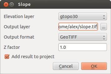
user interface for creating new raster layers (see Figure_raster_terrain).
The Raster Terrain Analysis Plugin can be used to calculate the
slope, aspect, hillshade, ruggedness index and relief for digital elevation
models (DEM). It is very simple to handle and provides an intuitive graphical
user interface for creating new raster layers (see Figure_raster_terrain).
Description of the analysis:
- Slope: Calculates the slope angle for each cell in degrees (based on first- order derivative estimation).
- Aspect: Exposition (starting with 0 for north direction, in degrees counterclockwise).
- Hillshade: Creates a shaded map using light and shadow to provide a more three-dimensional appearance for a shaded relief map. The output map is a Single band gray reflecting the gray value of the pixels.
- Ruggedness Index: A quantitative measurement of terrain heterogeneity as described by Riley et al. (1999). It is calculated for every location by summarizing the change in elevation within the 3x3 pixel grid.
- Relief: Creates a shaded relief map from digital elevation data. Implemented is a method to choose the elevation colors by analysing the frequency distribution. The output map is a multiband color with three bands reflecting the RGB values of the shaded relief.
Raster Terrain Modelling Plugin (slope calculation)
Using the plugin
- Start QGIS and load the gtopo30 raster layer from the GRASS sample location.
- Load the Raster Terrain Analysis plugin in the Plugin Manager (see The Plugins Dialog).
- Select an analysis method from the menu (e.g., Raster ‣ Terrain Analysis ‣ Slope). The Slope dialog appears as shown in Figure_raster_terrain.
- Specify an output file path, and an output file type.
- Click [OK].