` `
メタサーチカタログのクライアント
前書き
メタサーチは、Web(CSW)の標準のためのOGCカタログ・サービスをサポートする、メタデータカタログ・サービスと対話するQGISプラグインです。
メタサーチはQGIS内のメタデータ・カタログの検索に簡単で直感的なアプローチでユーザーフレンドリーなインターフェイスを提供します。
Search and results of Services in Metasearch
インストール
メタサーチはQGIS 2.0以降にデフォルトで含まれています。すべての依存関係は、メタサーチの中に含まれています。
Install MetaSearch from the QGIS plugin manager, or manually from http://plugins.qgis.org/plugins/MetaSearch.
QGISでメタデータカタログを使用して作業する
CSW(Web用カタログサービス)
CSW (Catalog Service for the Web) is an OGC (Open Geospatial Consortium) specification, that defines common interfaces to discover, browse and query metadata about data, services, and other potential resources.
起動
To start MetaSearch, click  icon or select Web ‣
MetaSearch ‣ MetaSearch via the QGIS main menu. The MetaSearch dialog will
appear. The main GUI consists of three tabs: Services,
Search and Settings.
icon or select Web ‣
MetaSearch ‣ MetaSearch via the QGIS main menu. The MetaSearch dialog will
appear. The main GUI consists of three tabs: Services,
Search and Settings.
カタログサービスを管理する
カタログサービスを管理する
The Services tab allows the user to manage all available catalog services. MetaSearch provides a default list of Catalog Services, which can be added by pressing [Add default services] button.
表示されているすべてのカタログ・サービス・エントリには、ドロップダウン選択ボックスをクリックしてください。
To add a Catalog Service entry, click the [New] button, and enter a Name for the service, as well as the URL (endpoint). Note that only the base URL is required (not a full GetCapabilities URL). Clicking [OK] will add the service to the list of entries.
To edit an existing Catalog Service entry, select the entry you would like to edit and click the [Edit] button, and modify the Name or URL values, then click [OK].
To delete a Catalog Service entry, select the entry you would like to delete and click the [Delete] button. You will be asked to confirm deleting the entry.
メタサーチは、読み込みとXMLファイルへの接続を保存できます。アプリケーション間で設定を共有する必要がある場合に便利です。以下は、XMLファイル形式の一例です。
<?xml version="1.0" encoding="UTF-8"?>
<qgsCSWConnections version="1.0">
    <csw name="Data.gov CSW" url="https://catalog.data.gov/csw-all"/>
    <csw name="Geonorge - National CSW service for Norway" url="http://www.geonorge.no/geonetwork/srv/eng/csw"/>
    <csw name="Geoportale Nazionale - Servizio di ricerca Italiano" url="http://www.pcn.minambiente.it/geoportal/csw"/>
    <csw name="LINZ Data Service" url="http://data.linz.govt.nz/feeds/csw"/>
    <csw name="Nationaal Georegister (Nederland)" url="http://www.nationaalgeoregister.nl/geonetwork/srv/eng/csw"/>
    <csw name="RNDT - Repertorio Nazionale dei Dati Territoriali - Servizio di ricerca" url="http://www.rndt.gov.it/RNDT/CSW"/>
    <csw name="UK Location Catalogue Publishing Service" url="http://csw.data.gov.uk/geonetwork/srv/en/csw"/>
    <csw name="UNEP/GRID-Geneva Metadata Catalog" url="http://metadata.grid.unep.ch:8080/geonetwork/srv/eng/csw"/>
</qgsCSWConnections>
To load a list of entries, click the [Load] button. A new window will appear; click the [Browse] button and navigate to the XML file of entries you wish to load and click [Open]. The list of entries will be displayed. Select the entries you wish to add from the list and click [Load].
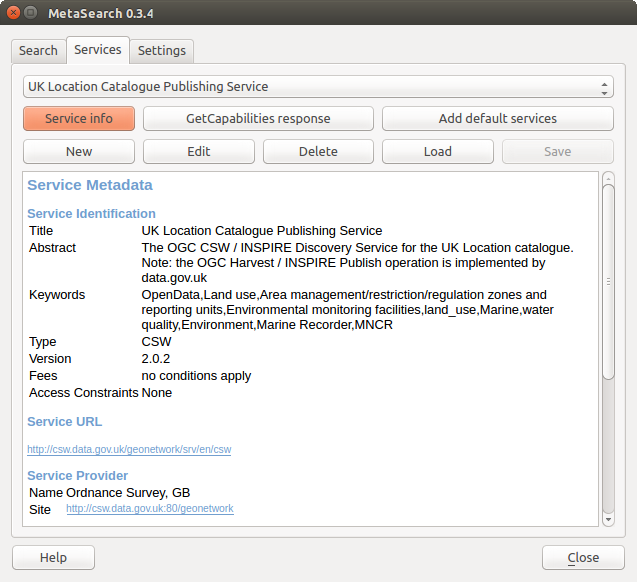
Click the [Service info] button to displays information about the selected Catalog Service such as service identification, service provider and contact information. If you would like to view the raw XML response, click the [GetCapabilities response] button. A separate window will open displaying Capabilities XML.
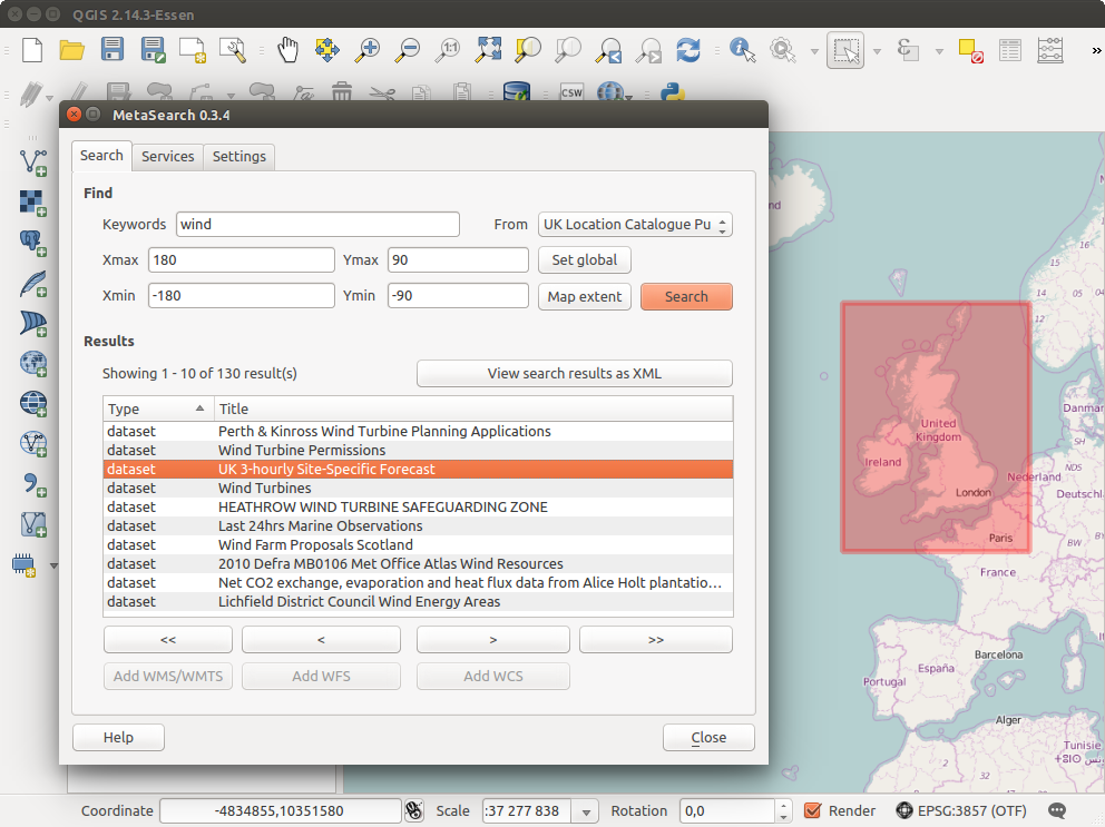
検索カタログサービス
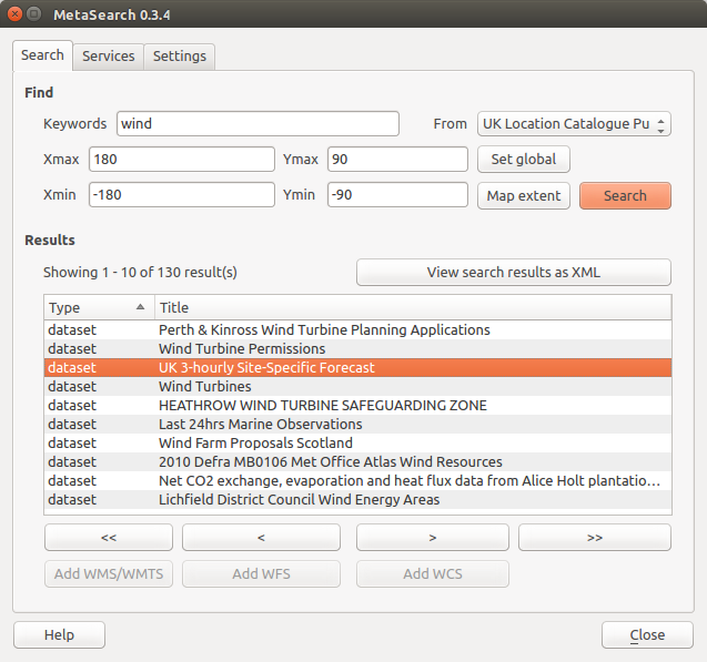
カタログサービスの検索
サーチ タブでは、ユーザーがデータやサービス、設定された各種検索パラメーターと表示結果のカタログサービスを照会できます。
次の検索パラメーターを使用できます。
キーワード :フリーテキスト検索キーワード;
From :クエリを実行する対象のカタログ・サービス
- Bounding box: the spatial area of interest to filter on defined by Xmax, Xmin, Ymax, and Ymin. Click [Set global] to do a global search, click [Map extent] to do a search on the visible area only or manually enter custom values as desired.
Clicking the [Search] button will search the selected Metadata Catalog. Search results are displayed in a list and are sortable by clicking on the column title. You can navigate through search results with the directional buttons below the search results. Clicking the [View search results as XML] button opens a window with the service response in raw XML format.
Clicking a result will provides the following options:
メタデータレコードが関連するバウンディングボックスを持っている場合、バウンディングボックスのフットプリントが地図上に表示されます;
レコードをダブルクリックすると、関連するアクセスリンクを持つレコードのメタデータを表示します。リンクをクリックすると、ユーザーのWebブラウザでリンクを開きます
- if the record is an OGC web service (WMS/WMTS, WFS, WCS), the appropriate [Add to WMS/WMTS|WFS|WCS] buttons will be enabled for the user to add to QGIS. When clicking this button, MetaSearch will verify if this is a valid OWS. The OWS will then be added to the appropriate QGIS connection list, and the appropriate WMS/WMTS|WFS|WCS connection dialog will then appear.
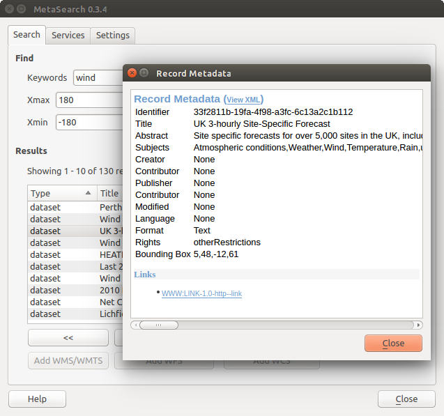
メタデータレコードの表示
設定
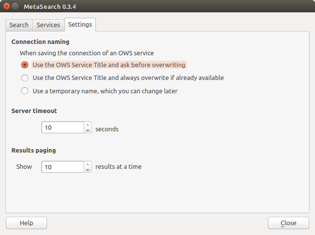
Metasearch setting
以下の settings 設定 でメタサーチを細かくチューニングできます:
- Connection naming: when adding an OWS connection (WMS/WMTS|WFS|WCS), the connection is stored with the various QGIS layer provider. Use this setting to set whether to use the name provided from MetaSearch, whether to overwrite or to use a temporary name;
Results paging 結果のページ設定 :メタデータカタログを検索するときに、ページごとに表示する結果の数。デフォルト値は10です
Timeout 時間切れ:メタデータカタログの検索時に、接続の試みを阻止するための秒数。デフォルト値は10です